- Maria Pronchishcheva Bay
-
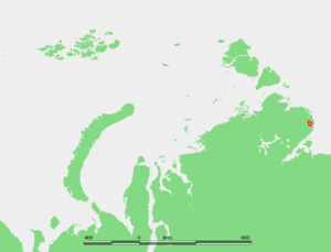 Map showing the location of Maria Pronchishcheva Bay.
Maria Pronchishcheva Bay (Russian: Бухта Марии Прончищевой, or Bukhta Marii Pronchishchevoy) is a deep gulf in the Laptev Sea. It is located about 75 km north of the mouth of the Khatanga Gulf, on the eastern side of the Taymyr Peninsula.
Maria Pronchishcheva Bay is narrow (about 4 km in average) and long (about 60 km from the mouth to its deepest recess). Lat 75° 45' and long 113°.
This gulf has the Byrranga Mountains in the west, so that quite a few rivers, two of them of considerable size, flow into it from the west and the southwest.
The climate in the area is exceptionally severe, with prolonged, bitter winters, so that this gulf is covered by ice most of the year.
Maria Pronchishcheva Bay and its surrounding area belongs to the Krasnoyarsk Krai administrative division of the Russian Federation.
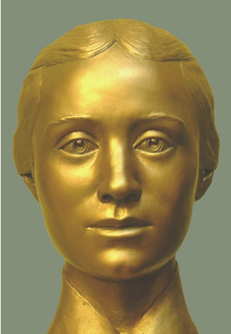
This bay is named after pioneering Russian explorer Vasili Pronchishchev's wife Maria[1].
History
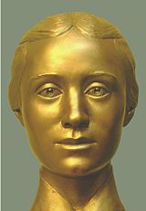 Maria Pronchishcheva (forensic facial reconstruction)
In 1933 icebreaker Rusanov, commaded by Captain Yerokhin brought a party led by S. P. Zhuravlev to Maria Pronchishcheva Bay and unloaded men, women and materials there. The plan was to establish a permanent base camp in the shores of this gulf in order to exploit the resources of this area of the Soviet Arctic. The men were experienced in trapping and the idea was that they should get their own food.
In the spring of the following year, several of the 21 people of the base (ten men, four women and seven children) were afflicted with scurvy. They were healed by Dr. Urvantseva, who travelled by dogsled from the provisional wintering station that had been set by her husband scientist Nikolay Urvantsev at the Komsomolskaya Pravda Islands the same year. The doctor stayed 11 days at the Bukhta Marii Pronchishchevoy camp until she could see clear signs of improvement as a result of the dietary changes prescribed by her.
During the 1930s the whole area surrounding Maria Pronchishcheva Bay experienced a limited boom owing to the first icebreaker convoys plying the Northern Sea Route. Tiksi Bay and Mys Shmidta had become airports and nearby Nordvik was "a growing town."
References
- William Barr, The First Soviet Convoy to the Mouth of the Lena.
- Exploration of the area: [1] and[2]
- Geography (detailed map of the gulf in Russian): [3]
- History of the area: [4]
Coordinates: 75°38′00″N 112°58′01″E / 75.6333°N 112.967°E

This Krasnoyarsk Krai location article is a stub. You can help Wikipedia by expanding it.