- History of Antarctica
The history of
Antarctica emerges from early Western theories of a vast continent, known asTerra Australis , believed to exist in the far south of the globe. The rounding of theCape of Good Hope andCape Horn in the 15th and 16th centuries proved that "Terra Australis Incognita" ("Unknown Southern Land"), if it existed, was a continent in its own right. In 1773James Cook crossed theAntarctic Circle for the first time but although he discovered nearby islands, he did not catch sight of Antarctica itself.In 1820, several expeditions claimed to have been the first to have sighted Antarctica. The first landing was probably just over a year later when American Captain John Davis, a sealer, set foot on the ice. Once the
North Pole had been reached in 1909, several expeditions attempted to reach theSouth Pole . Many resulted in injury and death. The NorwegianRoald Amundsen finally claimed the prize following a dramatic race with the BritonRobert Falcon Scott in December 1911.The search for "Terra Australis Incognita"
In the
Western world , belief in aTerra Australis —a vast continent located in the far south of the globe to "balance" out the northern lands ofEurope ,Asia andNorth Africa —had existed for centuries.Aristotle had postulated a symmetry of the earth, which meant that there would be equally habitable lands south of the known world. The Greeks suggested that these two hemispheres, north and south, were divided by a 'belt of fire'Fact|date=February 2007.It was not until
Prince Henry the Navigator began in 1418 to encourage the penetration of the torrid zone in the effort to reachIndia by circumnavigatingAfrica that the exploration of the southern hemisphere began. In 1473 Portuguese navigatorLopes Gonçalves proved that theequator could be crossed, and cartographers and sailors began to assume the existence of another, temperate continent to the south of the known world.[
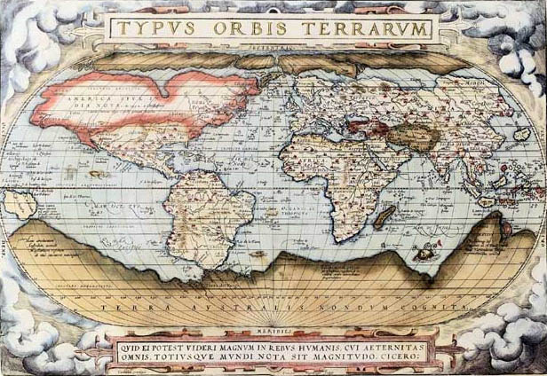
thumb|right|250px|In_1570_a_map_by_Ortelius showed the imagined link between the proposed continent of Antarctica andSouth America . Note also the proposed landmasses surrounding theNorth Pole .]The doubling of the
Cape of Good Hope in 1487 by Bartholomew Diaz first brought explorers within touch of the Antarctic cold, and proved that there was an ocean separatingAfrica from any Antarctic land that might exist. In 1513, the Ottoman Turkish admiralPiri Reis drew a world map that has been said to show part of the Antarctic continent.Ferdinand Magellan , who passed through theStraits of Magellan in 1520, assumed that the islands ofTierra del Fuego to the south were an extension of this unknown southern land, and it appeared as such on a map byOrtelius : "Terra australis recenter inventa sed nondum plene cognita" ("Southern land recently discovered but not yet known").Fact|date=February 2007European geographers connected the coast of Tierra del Fuego with the coast of New Guinea on their globes and allowing their imaginations to run riot in the vast unknown spaces of the south Atlantic, south Indian and Pacific oceans. They sketched the outlines of the "Terra Australis Incognita" ("Unknown Southern Land"), a vast continent stretching in parts into the tropics. The search for this great south land or Third World was a leading motive of explorers in the 16th and the early part of the 17th centuries.
Quirós in 1606 took possession for the king of Spain all of the lands he had discovered in Australia del Espiritu Santo (theNew Hebrides ) and those he would discover "even to the Pole".Francis Drake like Spanish explorers before him had speculated that there might be an open channel south of Tierra del Fuego. Indeed, when Schouten and Le Maire discovered the southern extremity of Tierra del Fuego and named it Cape Horn in 1615, they proved that the Tierra del Fuego archipelago was of small extent and not connected to the southern land.Finally, in 1642
Tasman showed that evenNew Holland (Australia) was separated by sea from any continuous southern continent.[

sic ) label without any charted landmass.]Voyagers round the Horn frequently met with contrary winds and were driven southward into snowy skies and ice-encumbered seas; but so far as can be ascertained none of them before 1770 reached the Antarctic Circle, or knew it, if they did. The story of the discovery of land in 64° S. by Dirk Gerritz on board the "Blijde Boodschap" in 1599 was shown to be the result of a mistakeFact|date=February 2007 of a commentator,
Kasper Barlaeus , in 1622. A similar story of sighting "snow-covered mountains" beyond the 64° S in 1603 is told of the SpanishGabriel de Castilla [http://www.ejercito.mde.es/mexterior/webantartida/docs/extras/GABRIEL%20DE%20CASTILLA.pdf Don Gabriel de Castilla, primer avistador de la Antártica] , byChile an historian Isidoro Vázquez de Acuña (Spanish language)] .Better documented is the visit to South Georgia by
Anthony de la Roché in 1675, the first ever discovery of land south of theAntarctic Convergence . [Dalrymple, Alexander. (1771). "A Collection of Voyages Made to the Ocean Between Cape Horn and Cape of Good Hope". Two volumes. London.] [Headland, Robert K. (1984). "The Island of South Georgia", Cambridge University Press. ISBN 0 521 25274 1] Soon after the voyage cartographers started to depict on their maps ‘Roché Island’, honouring the discoverer.James Cook was aware of la Roché's discovery when surveying and mapping the island in 1775. [Cook, James. (1777). [http://www.gutenberg.org/files/15869/15869-8.txt "A Voyage Towards the South Pole, and Round the World. Performed in His Majesty's Ships the Resolution and Adventure, In the Years 1772, 1773, 1774, and 1775. In which is included, Captain Furneaux's Narrative of his Proceedings in the Adventure during the Separation of the Ships"] . Volume II. London: Printed for W. Strahan and T. Cadell. ()]It may safely be said that all the navigators who fell in with the southern ice up to 1750 did so by being driven off their course and not of set purpose. An exception may perhaps be made in favor of
Halley 's voyage in HMS "Paramour" for magnetic investigations in the South Atlantic when he met the ice in 52° S. in January 1700; but that latitude was his farthest south. A determined effort on the part of the French naval officerPierre Bouvet to discover the South Land described by a half legendarysieur de Gonneyville resulted only in the discovery ofBouvet Island in 54°10′ S., and in the navigation of 48° of longitude of ice-cumbered sea nearly in 55° S. in 1730.In 1771, Yves Joseph Kerguelen sailed from
France with instructions to proceed south fromMauritius in search of "a very large continent." He lighted upon a land in 50° S. which he called South France, and believed to be the central mass of the southern continent. He was sent out again to complete the exploration of the new land, and found it to be only an inhospitable island which he renamed in disgust the Isle of Desolation, but in which posterity has recognized his courageous efforts by naming it Kerguelen Land.1911|article=Polar Regions]outh of the Antarctic Circle
The obsession of the undiscovered continent culminated in the brain of
Alexander Dalrymple , the brilliant and erratichydrographer who was nominated by theRoyal Society to command theTransit of Venus expedition toTahiti in 1769. The command of the expedition was given by the admiralty to CaptainJames Cook . Sailing in 1772 with the "Resolution", a vessel of 462 tons under his own command and the "Adventure" of 336 tons under CaptainTobias Furneaux , Cook first searched in vain forBouvet Island , then sailed for 20 degrees of longitude to the westward in latitude 58° S, and then 30° eastward for the most part south of 60° S, a higher southern latitude than had ever been voluntarily entered before by any vessel. OnJanuary 17 ,1773 theAntarctic Circle was crossed for the first time in history and the two ships reached nowrap|67° 15' S by nowrap|39° 35' E, where their course was stopped by ice.Cook then turned northward to look for French Southern and Antarctic Lands, of the discovery of which he had received news at
Cape Town , but from the rough determination of his longitude by Kerguelen, Cook reached the assigned latitude 10° too far east and did not see it. He turned south again and was stopped by ice in nowrap|61° 52′ S by 95° E and continued eastward nearly on the parallel of 60° S to 147° E. OnMarch 16 , the approaching winter drove him northward for rest toNew Zealand and the tropical islands of the Pacific. In November 1773, Cook left New Zealand, having parted company with the "Adventure", and reached 60° S by 177° W, whence he sailed eastward keeping as far south as the floating ice allowed. The Antarctic Circle was crossed onDecember 20 and Cook remained south of it for three days, being compelled after reaching nowrap|67° 31′ S to stand north again in 135° W.A long detour to nowrap|47° 50′ S served to show that there was no land connection between New Zealand and
Tierra del Fuego . Turning south again, Cook crossed the Antarctic Circle for the third time at nowrap|109° 30′ W before his progress was once again blocked by ice four days later at nowrap|71° 10′ S by nowrap|106° 54′ W. This point, reached onJanuary 30 ,1774 , was the farthest south attained in the 18th century. With a great detour to the east, almost to the coast of South America, the expedition regained Tahiti for refreshment. In November 1774, Cook started from New Zealand and crossed the South Pacific without sighting land between 53° and 57° S to Tierra del Fuego; then, passing Cape Horn onDecember 29 , he discovered the Isle of Georgia and Sandwich Land, the only ice-clad land he had seen, before crossing the South Atlantic to the Cape of Good Hope between 55° and 60°. He thereby laid open the way for future Antarctic exploration by exploding the myth of a habitable southern continent. Cook's most southerly discovery of land lay on the temperate side of the 60th parallel, and he convinced himself that if land lay farther south it was practically inaccessible and of no economic value.First sighting of land
The first land south of the parallel 60° south latitude was discovered by the Englishman William Smith, who sighted
Livingston Island onFebruary 19 ,1819 . A few months later Smith returned to explore the other islands of the South Shetlands archipelago, landed onKing George Island , and claimed the new territories for Britain.In the meantime, the Spanish Navy ship San Telmo sank in September 1819 when trying to cross Cape Horn. Parts of her wreckage were found months later by sealers on the north coast of
Livingston Island (South Shetlands ). It is unknown if some survivor managed to be the first setting foot on these Antarctic islands.The first confirmed sighting of mainland Antarctica cannot be accurately attributed to one single person. It can, however, be narrowed down to three individuals. According to various sources, [cite web |url=http://www.nsf.gov/pubs/1997/antpanel/antpan05.pdf |title=Antarctica —past and present |author=U.S. Antarctic Program External Panel |publisher=
NSF |accessdate=2007-11-14] [cite web |url=http://quest.arc.nasa.gov/antarctica/background/NSF/palmer.html |title=Nathaniel Brown Palmer |author=Guy G. Guthridge |publisher=NASA |accessdate=2007-11-14] [http://arcane.ucsd.edu/pstat.html] three men all sighted Antarctica within days or months of each other:Fabian von Bellingshausen , a captain in the Russian Imperial Navy;Edward Bransfield , a captain in the British navy; andNathaniel Palmer , an American sealer out of Stonington, Connecticut. It is certain that onJanuary 28 ,1820 (New Style), the expedition led byFabian von Bellingshausen andMikhail Petrovich Lazarev on two ships reached a point within 20 miles (40 km) of the Antarctic mainland and saw ice-fields there. OnJanuary 30 ,1820 , Bransfield sightedTrinity Peninsula , the northernmost point of the Antarctic mainland, while Palmer sighted the mainland in the area south of Trinity Peninsula in November 1820. Bellingshausen's expedition also discoveredPeter I Island andAlexander I Island , the first islands to be discovered south of the circle.Exploration
Only slightly more than a year later, the first landing on the Antarctic mainland was arguably by the American Captain John Davis, a sealer, who claimed to have set foot there on
February 7 ,1821 , though this is not accepted by all historians. [cite web |url=http://www.spri.cam.ac.uk/resources/infosheets/19.html |title=Summary of the Peri-Antarctic Islands |author=R.K. Headland |publisher=Scott Polar Research Institute |accessdate=2007-11-14]In December 1821, Nathaniel Palmer, an American sealer looking for seal breeding grounds, sighted what is now known as the
Antarctic Peninsula , located in the continent's northwestern quadrant. In 1823,James Weddell , a British sealer, sailed into what is now known as theWeddell Sea .The first person to realize that he had actually discovered a whole continent was
Charles Wilkes , the commander of aUnited States Navy expedition.cite web |url=http://www.quarkexpeditions.com/antarctica/exploration.shtml |title=ANTARCTIC EXPLORATION—CHRONOLOGY |accessdate=2006-10-20 |publisher=Quark Expeditions |year=2004] His 1840 voyage discovered what is now known asWilkes Land , on the southeast quadrant of the continent.After the
North Magnetic Pole was located in 1831, explorers and scientists began looking for theSouth Magnetic Pole . One of the explorers,James Clark Ross , a British naval officer, identified its approximate location, but was unable to reach it on his trip in 1841. Commanding the British ships "Erebus" and "Terror", he braved the pack ice and approached what is now known as theRoss Ice Shelf , a massive floatingice shelf over convert|100|ft|m high. His expedition sailed eastward along the southern Antarctic coast discovering mountains which were since named after his ships:Mount Erebus , the most active volcano on Antarctica, and Mount Terror.The first documented landing on the mainland of
East Antarctica was atVictoria Land by the American sealerMercator Cooper onJanuary 26 ,1853 . [ [http://www.antarctic-circle.org/firsts.htm Antarctic Circle—Antarctic First] ]In 1897, an expedition led by Belgian
Adrian de Gerlache leftAntwerp ,Belgium for Antarctica. The multi-national crew included aRomania n zoologist (Emil Racoviţă ), a Polish geologist (Henryk Arctowski ), a Belgian navigator/astronomer (George Lecointe ), several Norwegians, includingRoald Amundsen , and an American surgeon, Dr.Frederick Cook . In 1898, they became the first men to spend winter on Antarctica, when their ship Belgica became trapped in the ice. They became stuck onFebruary 28 ,1898 , and only managed to get out of the ice onMarch 14 ,1899 . During their forced stay, several men lost their sanity, not only because of the Antarctic winter night and the endured hardship, but also because of the language problems between the different nationalities. A year later a British expedition commanded by NorwegianCarstens Borchgrevink became the first to intentionally spend winter on the continent itself.cite web |url=http://www.south-pole.com/p0000087.htm |title=Carsten Borchgrevink:1864-1934 |accessdate=2006-10-20]British National Antarctic Expedition ("Discovery")
The British "National Antarctic Expedition" (1901–1904), led by
Robert Falcon Scott , came to within 857 km (463 nautical miles) of the South Pole from its base atMcMurdo Sound .cottish National Antarctic Expedition
In 1903, the
Scottish National Antarctic Expedition established "Osmond House", a meteorological observatory onLaurie Island in the South Orkneys. A year later, ownership of the base was passed toArgentina and it was renamed toOrcadas Base . It is the continent's oldest permanent base, [cite web |url=http://www.south-pole.com/p0000093.htm |title=William S. Bruce |publisher=South-Pole.com |accessdate=2007-11-14] and, until World War II, the only one present.British Imperial Antarctic Expedition ("Nimrod")
Ernest Shackleton , who had been a member of Scott's expedition, organized and led the British Imperial Antarctic Expedition (1907-09), again with the primary objective of reaching the South Pole. It came within 180 km (97 nautical miles) before having to turn back. during the expedition, Shackleton discovered theBeardmore Glacier and was the first to reach the polar plateau. Parties led byT. W. Edgeworth David also became the first to climbMount Erebus and to reach theSouth Magnetic Pole .Race to the Pole ("Fram" and "Terra Nova")
On
December 14 ,1911 , a party led by Norwegian polar explorerRoald Amundsen from the ship "Fram" became the first to reach theSouth Pole , using a route from theBay of Whales (his campPolheim and up theAxel Heiberg Glacier . Amundsen was followed byRobert Falcon Scott from the "Terra Nova" over a month later, using the route pioneered by Shackleton. Scott's party later died on the return journey after being delayed by a series of accidents, bad weather, and the declining physical condition of the men. TheAmundsen-Scott South Pole Station was later named after these two men.Imperial Trans-Antarctic Expedition ("Endurance")
The
Imperial Trans-Antarctic Expedition of 1914, led by Ernest Shackleton, set out to cross the continent via the pole, but their ship, the "Endurance", was trapped and crushed by pack ice before they even landed. The expedition members survived after an epic journey on sledges over pack ice toElephant Island . Then Shackleton and five others crossed the Southern Ocean, in anopen boat called "James Caird", and then trekked overSouth Georgia to raise the alarm at the whaling stationGrytviken .Exploration by air: 1930s to 1950s
US Navy Rear Admiral
Richard Evelyn Byrd led five expeditions to Antarctica during the 1930s, 1940s, and 1950s. He overflew the South Pole with pilotBernt Balchen on November 28 and 29, 1929, to match his overflight of the North Pole in 1926. Byrd's explorations had science as a major objective and pioneered the use of aircraft on the continent. Byrd is credited with doing more for Antarctic exploration than any other explorer. His expeditions set the scene for modern Antarctic exploration and research.In 1946, Admiral Byrd and more than 4,700 military personnel returned to Antarctica in an expedition called Operation "High Jump". Reported to the public as a scientific mission, the details were kept secret and it may have actually been a training or testing mission for the military. The expedition was, in both military or scientific planning terms, put together very quickly. The group contained an unusually high amount of military equipment, including an aircraft carrier, submarines, military support ships, assault troops and military vehicles. The expedition was planned to last for eight months but was unexpectedly terminated after only two months. With the exception of some eccentric entries in Admiral Byrd's diaries, no real explanation for the early termination has ever been officially given.
It was not until
October 31 ,1956 that anyone reached the South Pole again; on that day US Navy Rear AdmiralGeorge J. Dufek [http://www.history.navy.mil/wars/datesoct.htm] and others successfully landed a R4D Skytrain (Douglas DC-3 ) aircraft.During the
International Geophysical Year of 1957, a large number of expeditions to the Antarctic were mounted.Commonwealth Trans-Antarctic Expedition
In 1956, a
United States Navy expedition set up the first permanent based at the South Pole,Amundsen-Scott South Pole Station , by airlift, to support theInternational Geophysical Year . In 1958,Edmund Hillary 's party in the New Zealand party of theCommonwealth Trans-Antarctic Expedition became the third group in history to reach the South Pole by land, and the first group of motor vehicles to reach the pole. The British team led byVivian Fuchs , met them at the pole shortly afterwards. The expedition completed the first overland crossing of the continent by land via the South Pole. New Zealand mountaineer SirEdmund Hillary reached the Pole in early January 1958 using farm tractors equipped for polar travel, the first party since Scott's to reach the South Pole overland. Hillary was laying supply depots as part of theCommonwealth Trans-Antarctic Expedition and in typical Hillary style "detoured" to the pole because the trip had gone well. British explorer SirVivian Fuchs then arrived at the Pole from the opposite direction later in January, meeting Hillary. Fuchs continued on, making use of the provisions that Hillary had stored, and onMarch 2 succeeded in reachingScott Base , completing the overland transpolar crossing that Shackleton had envisaged.Recent history
The
Antarctic Treaty was signed onDecember 1 ,1959 and came into force onJune 23 ,1961 . Among other provisions, this treaty limitsmilitary activity in the Antarctic to the support of scientific research.A baby, named Emilio Marcos de Palma, was born near
Hope Bay onJanuary 7 ,1978 , becoming the first baby born on the continent. He also was born farther south than anyone in history. [ [http://www.antarctica.org/old/UK/Envirn/pag/antar_history/pag/science1.htm#science antarctica.org] —Science: in force... ]On
November 28 ,1979 , anAir New Zealand DC-10 on a sightseeing trip crashed intoMount Erebus onRoss Island , killing all 257 people on board.In March 2002, the 5,500 km² (2,120 square statute mile)
Iceberg B-22 broke off from theThwaites Ice Tongue and the Larsen B ice shelf on theAntarctic Peninsula , shattering into small fragments. The ice shelf was 200 metres thick and had a surface area of 3,250 square kilometres.On
November 23 2007 , the MS "Explorer" struck an iceberg and sunk, but all on board were rescued by nearby ships (including a passing Norwegiancruise ship , the MS "Nordnorge".See also
* History of Livingston Island
*List of Antarctic expeditions
*List of research stations in Antarctica
*History of South Georgia and the South Sandwich Islands References
Further reading
*
*
*External links
* [http://www.70south.com/ 70South: Antarctic History]
* [http://www.heritage-antarctica.org/ Antarctic Heritage Trust]
* [http://flickr.com/photos/terrymct/sets/72057594098237101/ Surveying Antarctica, 1957]
* [http://www.bigdeadplace.com/ Big Dead Place]Template group
list =
Wikimedia Foundation. 2010.