- New Swabia
-
Antarctic expeditions International agreements 1932–33 International Polar Year
1957–58 International Geophysical Year
1959 Antarctic Treaty SystemBritish Empire / Commonwealth 1901–04 Scott's first expedition
1907–09 Shackleton's first expedition
1910–13 Scott's second expedition
1911–14 Mawson's first expedition
1914–17 Shackleton's second expedition
1921–22 Shackleton's third expedition
1929–31 Mawson's second expedition
1934–37 Graham Land expedition
1943–45 Operation Tabarin
1955–58 Trans-Antarctic ExpeditionFrance 1903–05 Charcot's first expedition
1908–10 Charcot's second expeditionGermany 1901–03 Drygalski (Gauss) expedition
1911–12 Filchner expedition
1938–39 New Swabia expeditionJapan 1910–12 Japanese Antarctic Expedition Norway 1910–12 Amundsen expedition Sweden 1901–04 Swedish Antarctic Expedition United States 1928–30 Byrd's first expedition
1946–47 Operation Highjump
1947–48 Operation Windmill
1947–48 Ronne expedition
1955–56 Operation Deep FreezeNew Swabia (German: Neuschwabenland) is a cartographic name sometimes given to an area of Antarctica between 20°E and 10°W in Queen Maud Land, which within Norway is administered as a Norwegian dependent territory under the Antarctic Treaty System. New Swabia was explored by Germany in early 1939 and named after that expedition's ship, the Schwabenland, itself named after the German region of Swabia.[1]
Contents
Background
Like many other countries, Germany sent expeditions to the Antarctic region in the late 19th and early 20th centuries, most of which were scientific. The late 19th century expeditions to the Southern Ocean, South Georgia, the Kerguelen Islands, and the Crozet Islands were astronomical, meteorological, and hydrological, mostly in close collaboration with scientific teams from other countries. As the 19th century ended Germany began to focus on Antarctica.
The first German expedition to Antarctica was the Gauss expedition from 1901 to 1903. Led by Arctic veteran and geology professor Erich von Drygalski, this was the first expedition to use a hot-air balloon in Antarctica. It also found and named Kaiser Wilhelm II Land. The second German Antarctic expedition (1911–1912) was led by Wilhelm Filchner with a goal of crossing Antarctica to learn if it was one piece of land. As happened with other such early attempts, the crossing failed before it even began. The expedition discovered and named the Luitpold Coast and the Filchner Ice Shelf. A German whaling fleet was put to sea in 1937 and, upon its successful return in early 1938, plans for a third German Antarctic expedition were drawn up.
German Antarctic Expedition (1938–1939)
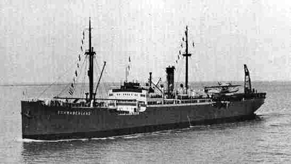
 MS Schwabenland in 1938
The third German Antarctic Expedition (1938–1939) was led by Alfred Ritscher (1879–1963), a captain in the Kriegsmarine (German navy). The main purpose was to find an area in Antarctica for a German whaling station, as a way to increase Germany’s production of fat. Whale oil was then the most important raw material for the production of margarine and soap in Germany and the country was the second largest purchaser of Norwegian whale oil, importing some 200,000 metric tonnes annually. Besides the disadvantage of being dependent on imports, it was thought that Germany would soon likely be at war, which was considered to put too much strain on Germany’s foreign currency reserves. Another goal was to scout possible locations for a German naval base.[2]
 1938–1939 expedition logo
On 17 December 1938 the New Swabia Expedition left Hamburg for Antarctica aboard the MS Schwabenland (a freighter built in 1925 and renamed in 1934 after the Swabia region in southern Germany) which could also carry and catapult aircraft. The secret[2] expedition had 33 members plus the Schwabenland's crew of 24. On 19 January 1939 the ship arrived at the Princess Martha Coast, in an area which had lately been claimed by Norway as Dronning Maud Land and began charting the region. Nazi German flags were placed on the sea ice along the coast. Naming the area Neu-Schwabenland after the ship, the expedition established a temporary base and in the following weeks teams walked along the coast recording claim reservations on hills and other significant landmarks. Seven photographic survey flights were made by the ship’s two Dornier Wal seaplanes named Passat and Boreas.[1][3] About a dozen 1.2 meter-long aluminum arrows, with 30 centimeter steel cones and three upper stabilizer wings embossed with swastikas, were air dropped onto the ice at turning points of the flight polygons (these arrows had been tested on the Pasterze glacier in Austria before the expedition).[1][3][4] Eight more flights were made to areas of keen interest and on these trips some of the photos were taken with colour film. Altogether they flew over hundreds of thousands of square kilometres and took more than 16,000 aerial photographs, some of which were published after the war by Ritscher. The ice-free Schirmacher Oasis, which now hosts the Maitri and Novolazarevskaya research stations, was spotted from the air by Richardheinrich Schirmacher (who named it after himself) shortly before the Schwabenland left the Antarctic coast on 6 February 1939.
On its return trip to Germany the expedition made oceanographic studies near Bouvet Island and Fernando de Noronha, arriving back in Hamburg on 11 April 1939. Meanwhile the Norwegian government had learned about the expedition through reports from whalers along the coast of Queen Maud Land.
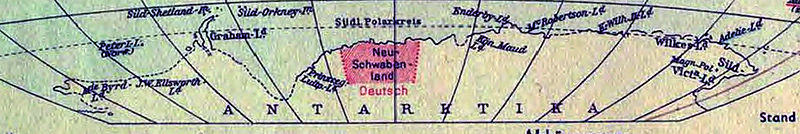 German map of Antarctica (1941) showing Neuschwabenland
Geographic features mapped by the expedition
Because the area was first explored by a German expedition, the name Neuschwabenland (or New Schwabenland or New Swabia) is still used for the region on some maps, as are many of the German names given to its geographic features.[5] Some geographic features mapped by the expedition were not named until the Norwegian-British-Swedish Antarctic Expedition (NBSAE) (1949–1952), led by John Schjelderup Giæver. Others were not named until they were remapped from aerial photographs taken by the Norwegian Antarctic Expedition (1958–1959). [6]
- Petermann Ranges
- Preuschoff Range
- Ritscher Peak
- Ritscher Upland
- Saetet Cirque
- Sandeggtind Peak
- Schirmacher Oasis
- Shatskiy Hill
- Stabben Mountain
- Storkvarvet Mountain
- Südliche Petermann Range
- Sverdrup Mountains
- Terningen Peak
- Tindeklypa
- Vorposten Peak
- Weyprecht Mountains
- Wohlthat Mountains
- Zhil'naya Mountain
- Zwiesel Mountain
Aftermath
Germany made no formal territorial claims to New Swabia.[7] No whaling station or other lasting bases were built there by Germany until the Georg-von-Neumayer-Station, a research facility, was established in 1981. Germany's current Neumayer-Station III is also in the region. New Swabia is a cartographic area of Queen Maud Land which within Norway is administered as a Norwegian dependent territory under the Antarctic Treaty System by the Polar Affairs Department of the Ministry of Justice and the Police.
See also
References
- ^ a b c McGonigal, David, Antarctica, frances lincoln ltd, 2009, ISBN 0711229805, 9780711229808, p 367
- ^ a b Hitler's Antarctic base: the myth and the reality, by Colin Summerhayes and Peter Beeching, Polar Record, Volume 43 Issue 1, pp.1–21 Cambridge University Press, 2007.
- ^ a b Boudewijn Büch. Eenzaam, Eilanden 2 ('Lonely, Islands 2'), Holland 1994
- ^ Ritscher's expedition report, more information pending
- ^ e.g., National Geographic Atlas of the World, Eighth Edition, 2005
- ^ USGS GNIS
- ^ Heinz Schön, Mythos Neu-Schwabenland. Für Hitler am Südpol, Bonus, Selent 2004, p. 106, ISBN 3-935962-05-3
Literature
- D.T. Murphy, German exploration of the polar world. A history, 1870–1940 (Nebraska 2002).
External links
- Photographs of the MS Schwabenland and its seaplanes (text in German)
- More photographs of the MS Schwabenland (text in German)
- 1901–03 German Antarctic Expedition Scott Polar Research Institute
- 1911–12 German Antarctic Expedition Scott Polar Research Institute
- Kartographische Arbeiten und deutsche Namengebung in Neuschwabenland, Antarktis
Antarctic territorial claims Current 
Proposed Former - New Swabia
Antarctica Main articles - Antarctic
- History
- Geography
- Climate
- Expeditions
- Research stations
- Field camps
- Territorial claims
- Antarctic Treaty System
- Telecommunications
- Demographics
- Economy
- Tourism
- Transport
- Military activity in the Antarctic
Geographic regions - Antarctic Peninsula
- East Antarctica
- West Antarctica
- Extreme points of the Antarctic
- List of Antarctic and subantarctic islands
- Antarctica ecozone
Waterways Famous explorers Categories:- History of Antarctica
- Regions of Queen Maud Land
- Germany and the Antarctic
- 1938 in Antarctica
- 1939 in Antarctica


Wikimedia Foundation. 2010.