- Novaya Zemlya
-
 Novaya Zemlya
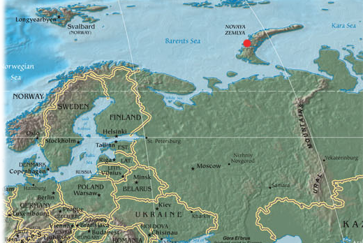
 location in relation to northern Europe
Novaya Zemlya (Russian: Но́вая Земля́, lit. New Land), also known in Dutch as Nova Zembla and in Norwegian as Gåselandet (lit. the Goose Land), is an archipelago in the Arctic Ocean in the north of Russia and the extreme northeast of Europe, the easternmost point of Europe lying at Cape Flissingsky on the northern island. Administratively, it is incorporated as Novaya Zemlya District, one of the twenty-one in Arkhangelsk Oblast, Russia.[1] Municipally, it is incorporated as Novaya Zemlya Urban Okrug.[2] Its population is 2,429 (2010 Census preliminary results),[3] of which 1,972 reside in Belushya Guba, an urban-type settlement that is the administrative center of Novaya Zemlya District. The population in 2002 was 2,716 (2002 Census).[4]
The indigenous population (from 1872[5][6] to the 1950s when it was resettled to the mainland) consisted of about 50–300 Nenetses[7] who subsisted mainly on fishing, trapping, reindeer herding, polar bear hunting and seal hunting.[8][9]
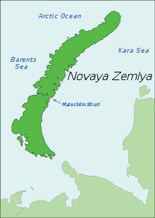
Novaya Zemlya consists of two major islands, separated by the narrow Matochkin Strait, and a number of smaller islands. The two main islands are Severny (northern) and Yuzhny (southern). Novaya Zemlya separates the Barents Sea from the Kara Sea. The total area is about 90,650 square kilometres (35,000 sq mi).
As Novaya Zemlya was a sensitive military area during the Cold War years, the Soviet Air Force maintained a presence at Rogachevo air base on the southern part of the island. It was used primarily for interceptor aircraft operations but also provided logistical support for the nearby nuclear test area. It was the site of the October 30, 1961 explosion of Tsar Bomba, the largest, most powerful nuclear weapon ever detonated.
Contents
Environment
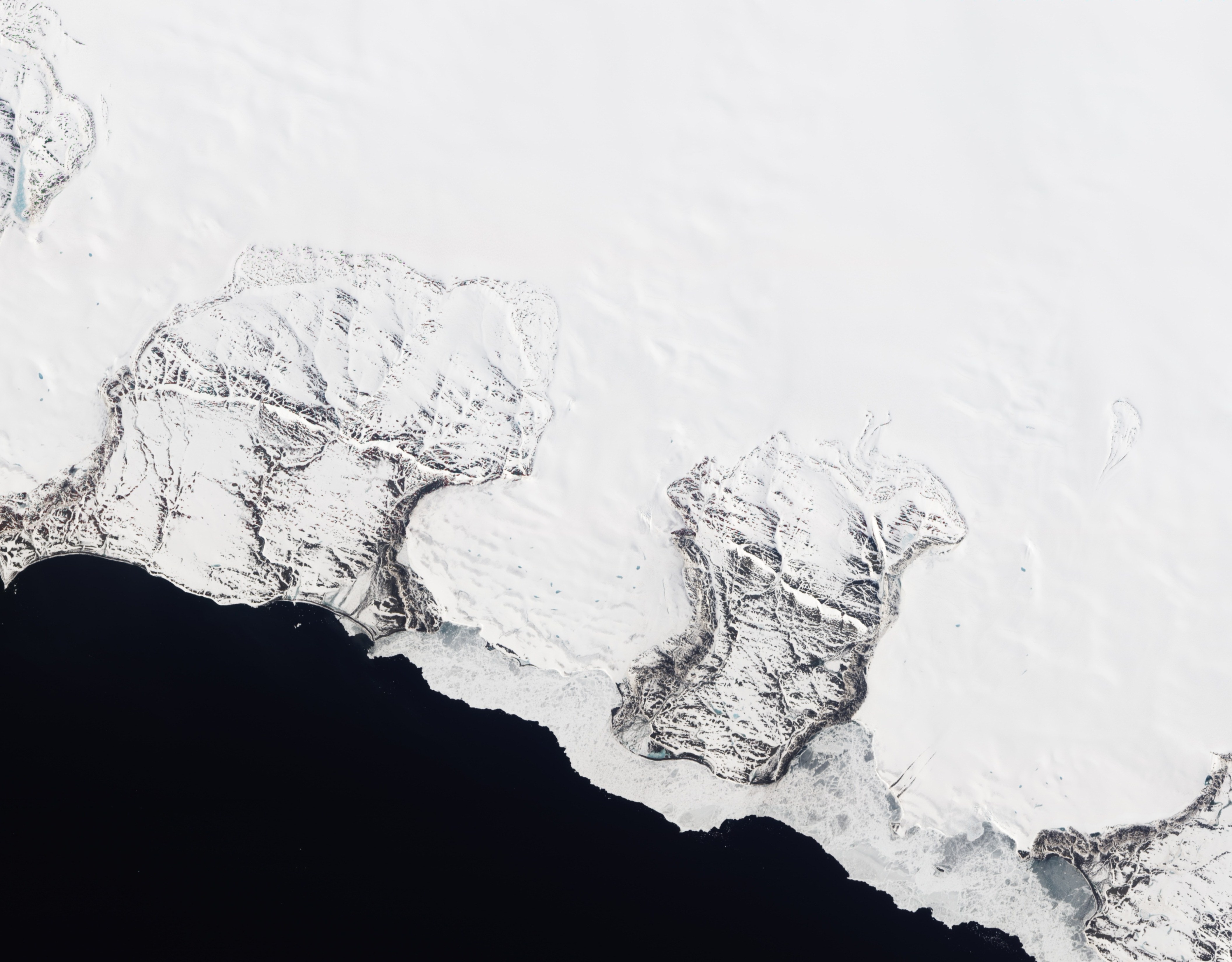
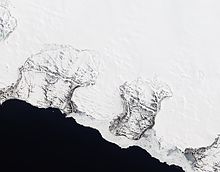 Natural-colour satellite image of Roze Glacier, Severny, fringed by sea ice.
Novaya Zemlya is the northern part of the Ural Mountains,[10] and the interior is mountainous throughout.[11] It is separated from the mainland by the Kara Strait.[11] The mountains reach a height of 1,547 metres (5,075 ft).[12] The northern island contains many glaciers, while the southern one has a tundra landscape.[8] Natural resources include copper, lead, and zinc.[8]
The ecology of Novaya Zemlya is influenced by its severe climate, but the region nevertheless supports a diversity of biota. One of the most notable species present is the polar bear, whose population in the Barents Sea region is genetically distinct from other polar bear subpopulations.[13]
History
Novaya Zemlya Test Site 
Map showing location of the siteType Nuclear test site Location 74°N 56°E / 74°N 56°ECoordinates: 74°N 56°E / 74°N 56°E Area land: 55,200 km2 (21,300 sq mi)
water: 36,000 km2 (14,000 sq mi)Operator Russian Federation (formerly Soviet Union) Status Active In use 1955 – present Testing Subcritical
testsnot known Nuclear
tests224 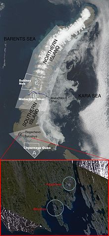 Novaya Zemlya's major test site boundaries and facilities
The Russians knew of Novaya Zemlya from the 11th century, when hunters from Novgorod visited the area.[11] For western Europeans, the search for the Northeast passage in the 16th century led to its exploration.[11] The first visit from a west European was by Hugh Willoughby in 1553, and he met Russian ships from the already established hunting trade.[11] Dutch explorer Willem Barents reached the west coast of Novaya Zemlya in 1594, and in a subsequent expedition of 1596 rounded the northern point and wintered on the north-east coast.[14] (Barents perished during the expedition, and may have been buried on the northern island.[15]) During a later voyage by Fyodor Litke in 1821–1824, the west coast was mapped.[11] Henry Hudson was another explorer who passed through Novaya Zemlya while searching for the Northeast Passage.[16]
The island was systematically surveyed by Pyotr Pakhtusov and Avgust Tsivolko in the early 1830s. The first permanent settlement was established in 1870 at Malye Karmakuly, which served as capital of Novaya Zemlya until 1924. Later the administrative center was transferred to Belushya Guba,[6][17] in 1935 to Lagernoe,[6] but then turned back to Belushya Guba.
Small numbers of Nenets were resettled to Novaya Zemlya in the 1870s in a bid by Russia to keep out the Norwegians. This population, then numbering 298, was removed to the mainland in 1957 before nuclear testing began.[9][18][19][20]
In 1943, during World War II, Novaya Zemlya briefly served as a secret seaplane base for the German Navy, to provide German surveillance of Allied ships en route to Siberia. The seaplane base was established by U-255, which was operating along the northern coast of Russia as part of 13th U-boat Flotilla.
Nuclear testing
In July 1954, Novaya Zemlya was designated the Novaya Zemlya Test Site, construction of which began in October[21] and existed during much of the Cold War. "Zone A", Chyornaya Guba (70°42′N 54°36′E / 70.7°N 54.6°E), was used in 1955–1962 and 1972–1975.[21] "Zone B", Matochkin Shar (73°24′N 54°54′E / 73.4°N 54.9°E), was used for underground tests in 1964–1990.[21] "Zone C", Sukhoy Nos (73°42′N 54°00′E / 73.7°N 54.0°E), was used in 1958–1961 and was the 1961 explosion site of the 100 megaton (fired device was a downgraded design to 50)Tsar Bomba, the biggest nuclear bomb ever detonated.[21]
Other tests occurred elsewhere throughout the islands, with an official testing range covering over half of the landmass. In September 1961 two propelled thermonuclear warheads were launched from Vorkuta Sovetsky and Salekhard respectively to target areas on Novaya Zemlya. The launch rocket was subsequently deployed to Cuba.[22]
1963 saw the implementation of the Limited Test Ban Treaty outlawing most atmospheric nuclear tests.[23] The largest underground test at Novaya Zemlya took place on September 12, 1973, involving four nuclear devices of 4.2 megatons total yield. Although far smaller in blast power than the Tsar Bomba and other atmospheric tests, the confinement of the blasts underground led to pressures rivaling natural earthquakes. In the case of the September 12, 1973, test, a seismic magnitude of 6.97 on the Richter Scale was reached, setting off an 80 million ton avalanche that blocked two glacial streams and created a lake 2 kilometres (1.2 mi) in length.[23]
Over its history as a nuclear test site, Novaya Zemlya hosted 224 nuclear detonations with a total explosive energy equivalent to 265 megatons of TNT.[21] For comparison, all explosives used in World War II, including the detonations of two U.S. nuclear bombs, amounted to only two megatons.[23]
In 1988–1989, glasnost helped make the Novaya Zemlya testing activities public knowledge,[21] and in 1990 Greenpeace activists staged a protest at the site.[24] The last nuclear test explosion was in 1990 (also the last for the entire Soviet Union and Russia). The Ministry for Atomic Energy has performed a series of subcritical underwater nuclear experiments near Matochkin Shar each autumn since 1998.[25] These tests reportedly involve up to 100 grams (3.5 oz) of weapons-grade plutonium.[26]
See also
- Extreme points of Europe
- List of islands of Russia
- Novaya Zemlya effect
- Gusinaya Zemlya
References
- ^ Архангельское областное Собрание депутатов. Областной закон №65-5-ОЗ от 23 сентября 2009 г. «Об административно-территориальном устройстве Архангельской области», в ред. Областного закона №150-12-ОЗ от 4 мая 2010 г «О внесении изменений и дополнений в отдельные областные законы». Вступил в силу через десять дней со дня официального опубликования. Опубликован: "Волна", №43, 6 октября 2009 г. (Arkhangelsk Oblast Council of Deputies. Oblast Law #65-5-OZ of September 23, 2009 On the Administrative and Territorial Structure of Arkhangelsk Oblast, as amended by the Oblast Law #150-12-OZ of May 4, 2010 On Amending and Supplementing Certain Oblast Laws. Effective as of the day ten days after the official publication).
- ^ Архангельское областное Собрание депутатов. Областной закон №258-внеоч.-ОЗ от 23 сентября 2004 г. «О статусе и границах территорий муниципальных образований в Архангельской области (текст в ред. от 15 февраля 2010 г.)», в ред. Областного закона №309-23-ОЗ от 7 июля 2011 г «О внесении изменений и дополнений в отдельные Областные законы в сфере организации и осуществления местного самоуправления». Вступил в силу со дня официального опубликования. Опубликован: "Волна", №38, 8 октября 2004 г. (Arkhangelsk Oblast Council of Deputies. Oblast Law #258-vneoch.-OZ of September 23, 2004 On the Status and Borders of the Territories of the Municipal Formations in Arkhangelsk Oblast (text of rev. of February 15, 2010), as amended by the Oblast Law #309-23-OZ of July 7, 2011 On Amending and Supplementing Several Oblast Laws on the Subject of Organization and Implementation of the Local Self-Government. Effective as of the day of the official publication).
- ^ Федеральная служба государственной статистики (Federal State Statistics Service) (2011). "Предварительные итоги Всероссийской переписи населения 2010 года (Preliminary results of the 2010 All-Russian Population Census)" (in Russian). Всероссийская перепись населения 2010 года (All-Russia Population Census of 2010). Federal State Statistics Service. http://www.perepis-2010.ru/results_of_the_census/results-inform.php. Retrieved 2011-04-25.
- ^ Федеральная служба государственной статистики (Federal State Statistics Service) (2004-05-21). "Численность населения России, субъектов Российской Федерации в составе федеральных округов, районов, городских поселений, сельских населённых пунктов – районных центров и сельских населённых пунктов с населением 3 тысячи и более человек (Population of Russia, its federal districts, federal subjects, districts, urban localities, rural localities—administrative centers, and rural localities with population of over 3,000)" (in Russian). Всероссийская перепись населения 2002 года (All-Russia Population Census of 2002). Federal State Statistics Service. http://www.perepis2002.ru/ct/doc/1_TOM_01_04.xls. Retrieved 2010-03-23.
- ^ Новая земля - история заселения
- ^ a b c Новая земля в 1917—1941 гг.
- ^ http://www-ns.iaea.org/downloads/rw/waste-safety/north-test-site-final.pdf
- ^ a b c Novaya Zemlya in: "The Columbia Encyclopedia, 6th ed". http://www.highbeam.com/doc/1E1-NovayaZe.html. Retrieved 2006-10-14.
- ^ a b [www.npc.sarov.ru/issues/volume1/ussr_nt_volume_1_chapter_2.pdf ЯДЕРНЫЕ ИСПЫТАНИЯ СССР. ТОМ 1. ГЛАВА 2], p. 58.
- ^ "Novaya Zemlya, Northern Russia". NASA. http://visibleearth.nasa.gov/view_rec.php?id=5612. Retrieved 2006-10-14.
- ^ a b c d e f Novaya Zemlya in: "Encyclopaedia Britannica (11th ed.)". 1911. http://www.1911encyclopedia.org/Novaya_Zemlya. Retrieved 2006-10-14.
- ^ Russian military mapping. The highest point is located at 75°10′N 57°50′E / 75.167°N 57.833°E
- ^ C. Michael Hogan (2008) Polar Bear: Ursus maritimus, Globaltwitcher.com, ed. Nicklas Stromberg
- ^ Whitfield, Peter (1998). New Found Lands: Maps in the History of Exploration. UK: Routledge. ISBN 0-415-92026-4.
- ^ "Search for Barents: Evaluation of Possible Burial Sites on North Novaya Zemlya, Russia", Jaapjan J. Zeeberg et al., Arctic Vol. 55, No. 4 (December 2002) p. 329–338
- ^ Henry Hudson in: "Microsoft Encarta Online Encyclopedia 2006". Archived from the original on 2009-11-01. http://www.webcitation.org/5kx3FKhy9. Retrieved 2006-10-14.
- ^ Health, science and education, history and trade among others - news review from the Arkhangelsk region
- ^ "Nenets", Arctic Network for the Support of the Indigenous Peoples of the Russian Arctic
- ^ "The Nenets", The Red Book of the Peoples of the Russian Empire
- ^ "Nuclear Free Seas", Greenpeace
- ^ a b c d e f Khalturin, Vitaly I.; Rautian, Tatyana G.; Richards, Paul G.; Leith, William S. (2005). "A Review of Nuclear Testing by the Soviet Union at Novaya Zemlya, 1955–1990". Science and Global Security 13 (1): 1–42. doi:10.1080/08929880590961862. Archived from the original on 2006-09-08. http://web.archive.org/web/20060908073452/http://www.princeton.edu/~globsec/publications/pdf/13_1-2khalturin+NZ+1-42+.pdf. Retrieved 2006-10-14.
- ^ Testing the Kosmos 2 rocket
- ^ a b c Pratt, Sara (2005-11-28). "Frozen in Time: A Cold War Relic Gives up its Secrets". Lamont-Doherty Earth Observatory, Columbia University. http://www.ldeo.columbia.edu/news/2005/11_28_05.htm. Retrieved 2006-10-14.
- ^ "The early history of Greenpeace Russia". Greenpeace Russia. http://www.greenpeace.org/russia/en/features/23845. Retrieved 2006-10-14.
- ^ Jasinski, Michael; Chuen, Cristina; Ferguson, Charles D. (October 2002). "Russia: Of truth and testing". Bulletin of the Atomic Scientists 58 (5): 60–65. http://thebulletin.metapress.com/content/h70233211r4q425k/?p=69e8e9ca0a804b44a4b55c2f84b84b57&pi=16. Retrieved 2009-09-22.
- ^ "Russia: Central Test Site, Novaya Zemlya". Nuclear Threat Initiative. 2003-07-30. http://www.nti.org/db/nisprofs/russia/weafacl/othernuc/novayaze.htm. Retrieved 2006-10-14.
Further reading
- Serebryanny, Leonid (June 1997). "The colonization and peoples of Novaya Zemlya then and now". Nationalities Papers 25 (2): 301–309. doi:10.1080/00905999708408505.
External links
- Selected satellite views of nuclear test site Novaya Zemlya (global security).
- Environment, climate change, and history of exploration (Barents' wintering).
- Rozenberg Publishers - Climate and glacial history of the Novaya Zemlya Archipelago, Russian Arctic
- Nuclear tests in Novaya Zemlya, International Atomic Energy Agency Department of Nuclear Safety and Security.
- List of islands (Russian language)
Islands of the Barents Sea Barentsøya · Berkha Island · Bear Island · Dolgy Island · Edgeøya · Gorbovy Island · Hopen · Kharlov Island · Kildin Island · Kolguyev · Kongsøya · Kvitøya · Lumbovskiy Island · Mezhdusharsky Island · Morzhovets Island · Nordaustlandet · Novaya Zemlya · Pankratyev Island · Pinyegin and Kazimov Islands · Prince Charles Forland · Sengeyskiy Island · Severny Island · Spitsbergen · Svenskøya · Vaygach Island · Wilhelmøya · Yuzhny IslandCategories:- Novaya Zemlya
- Nuclear test sites
- Russian nuclear test sites


Wikimedia Foundation. 2010.