Barents Island

Barents Island

Infobox Islands
name = Barentsøya/Barents Island
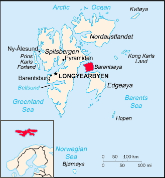

image caption =
image size =
locator

native name =
native name link =
nickname =
location = Arctic Ocean
coordinates = coord|78|25|N|21|27|E|type:isle_region:NO|display=inline,title
archipelago = Svalbard
total islands =
major islands =
area = 1,288 km², 558 km² glaciated.
perimeter = 205 km
highest mount = Schweinfurthberget
elevation = convert|590|m|ft|0|abbr=on|lk=on
country = Norway
country admin divisions title =
country admin divisions =
country admin divisions title 1 =
country admin divisions 1 =
country admin divisions title 2 =
country admin divisions 2 =
country capital city =
country largest city =
country largest city population =
country leader title =
country leader name =
country 1 =
country 1 admin divisions title =
country 1 admin divisions =
country 1 capital city =
country 1 largest city =
country 1 largest city population =
country 1 leader title =
country 1 leader name =
country 2 =
country 2 admin divisions title =
country 2 admin divisions =
country 2 capital city =
country 2 largest city =
country 2 largest city population =
country 2 leader title =
country 2 leader name =
population = 0
population as of =
density =
ethnic groups =

Barents Island ( _no. Barentsøya) is one of the smaller islands in the Svalbard archipelago, lying between Edge Island (Edgeøya) and Spitsbergen. It has no permanent inhabitants. Named for the Dutch explorer Willem Barents, it is a part of Norway.

An Arctic island, around half its area of 1288 km² is glaciated. To the north, in the sound between Barentsøya and Spitsbergen, lies the island of Kükenthaløya. To the south, the sound separating Barents Island from Edgeøya is Freemansundet.

ee also

* List of islands of Norway

External links

* [http://www.svalbard-images.com/spitsbergen/barentsoya-e.php Barentsøya] on Svalbard Images. (URL accessed 24 July, 2006)


Wikimedia Foundation. 2010.

Игры ⚽ Нужно сделать НИР?

Look at other dictionaries:

  • Barents Island — noun An island of Svalbard …   Wiktionary

  • Barents — may refer to:*Willem Barents, a Dutch navigator and explorer *Barents Sea, a part of the Arctic Ocean north of Norway and Russia, named after Willem Barents *Barents Region, along the coast of the Barents Sea *Barentsøya, an island in the… …   Wikipedia

  • Barents Sea — Location of the Barents Sea The Barents Sea (Norwegian: Barentshavet, Russian: Баренцево море or Barentsevo More) is a marginal sea of the Arctic Ocean,[1] …   Wikipedia

  • Barents Sea — a part of the Arctic Ocean between NE Europe and the islands of Spitzbergen, Franz Josef Land, and Novaya Zemlya. * * * Outlying portion of the Arctic Ocean. Named for the Dutch explorer Willem Barents, it is bounded by the Norwegian and… …   Universalium

  • Barents, Willem — ▪ Dutch navigator born c. 1550 died June 20, 1597, the Arctic       Dutch navigator who searched for a northeast passage from Europe to Asia and for whom the Barents Sea was named. Because of his extensive voyages, accurate charting, and the… …   Universalium

  • Kolguyev Island — ▪ island, Russia Russian  Ostrov Kolguyev        island, Arkhangelsk oblast (region), northwestern Russia. Kolguyev lies in the Barents Sea and is 45 miles (72 km) off the mainland. About 3,220 square miles (5,200 square km) in area, it is an… …   Universalium

  • Bear Island (Norway) — Infobox Islands name = Bear Island image caption = Bear Island is located north of mainland Norway, in the south of the native name = Bjørnøya native name link = Norwegian language nickname = location = Barents Sea coordinates =… …   Wikipedia

  • Morzhovets Island — Map of Morzhovets Island. Location of Morzhovets Island. Mor …   Wikipedia

  • Kolguyev Island — Native name: остров Колгуев Location of Kolguyev Island Geography Location Arctic Sea …   Wikipedia

  • Dolgy Island — Coordinates: 69°15′00″N 59°04′01″E / 69.250°N 59.067°E / 69.250; 59.067 …   Wikipedia

Share the article and excerpts

Direct link
Do a right-click on the link above
and select “Copy Link”