- Edgeøya
Infobox Islands
name = Edgeøya
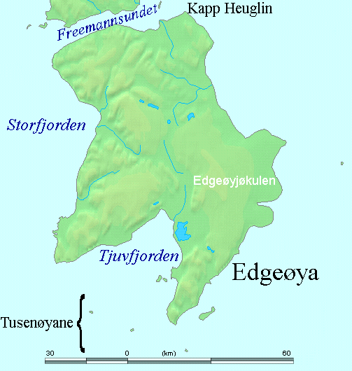
image caption =
image size =
locator
native name =
native name link =
nickname =
location =Arctic Ocean
coordinates = coord|77|40|N|22|30|E|type:isle_region:NO|display=inline,title
archipelago =Svalbard
total islands =
major islands =
area = 5,073km² , 2,102 km² glaciated (perimeter 502 km)
highest mount = Caltexfjellet
elevation = convert|590|m|ft|0|abbr=on|lk=on
country = Norway
country admin divisions title =
country admin divisions =
country admin divisions title 1 =
country admin divisions 1 =
country admin divisions title 2 =
country admin divisions 2 =
country capital city =
country largest city =
country largest city population =
country leader title =
country leader name =
country 1 =
country 1 admin divisions title =
country 1 admin divisions =
country 1 capital city =
country 1 largest city =
country 1 largest city population =
country 1 leader title =
country 1 leader name =
country 2 =
country 2 admin divisions title =
country 2 admin divisions =
country 2 capital city =
country 2 largest city =
country 2 largest city population =
country 2 leader title =
country 2 leader name =
population = 0
population as of =
density =
ethnic groups =Edgeøya, occasionally anglicised as Edge Island, is an uninhabited Norwegian
island in southeast of theSvalbard archipelago. AnArctic island, it forms part of theSouth East Svalbard Nature Reserve , home topolar bear s andreindeer . Its eastern side is covered by anice field . The island is 5,073square kilometer s (1,958 sq mi) in area, making it the third largest in the Svalbard archipelago. The island is named afterThomas Edge (died 1624), an English merchant and whaler. It is seldom visited today.History
The history of Edgeøya's discovery has been a matter of dispute. The Dutch
cartographer Petrus Plancius illustrated a coastline to the east of Spitsbergen in a chart of 1612. Indented, with islands offshore, and identified as "Gerrits Eylant", this has been identified by some historians (notably, Wieder in 1919) as the first record of Edgeøya's south coast. Another early chart apparently showing this coastline was produced byJoris Carolus , a Dutch navigator, in 1614. Carolus showed the coastline split into two parts: "Onbekende Cust" (meaning "Unknown Coast" in Dutch) in the west, and "Marfyn" in the east. Islands are shown offshore of Marfyn.Martin Conway argued in 1901 that Carolus' chart indicated he discovered Edgeøya in a 1614 expedition in which he had served as pilot, although left open the possibility that
Thomas Marmaduke of Hull may have found it one year earlier. Conway, however, did not know of Plancius' earlier chart. Wieder (1919) identified Plancius' coastline as that of Edgeøya and concluded that the island must have been discovered by Dutch seafarers. This would require there to have been previously forgotten Dutch expeditions to Svalbard betweenWillem Barents in 1596 and Plancius' production of the 1612 chart. Schilder points out that Plancius only copied some names from Mouris Willemsz's chart which was published in 1608 or earlier by Cornelis Claeszoon (British Library, London). That chart was unknown to Wieder. Thomas Edge, the Englishman from whom the island takes its current name, entered rather later into the fray, when a smallpinnace of his fleet discovered the island in 1616.Four Russian sailors were marooned on Edgeøya, or a small island off the coast of Edgeøya, from 1743 until September 1749. Three survived to tell an epic tale of survival.
While no major settlement grew upon Edgeøya, whaling and
walrus hunting were extensive industries in the area. Remains of these can be found offshore of Edgeøya, onBölscheøya in theTusenøyane group.Geography
Edgeøya is located at
geographical co-ordinates coord|77|40|N|22|30|E|display=inline. To the west liesStorfjorden , which separates Edgeøya fromSpitsbergen . To the north, the sound known asFreemansundet lies between Edgeøya andBarentsøya . In the northeast,Olgastretet separates Edgeøya fromKong Karls Land . Minor island groups lay to the east (Ryke Yseøyane ) and to the south (Tusenøyane ). The island's south coast in indented by its largestfjord ,Tjuvfjorden . The island's northernmost point is Kapp Heuglin, a cape named in August 1870 for the German explorerTheodor von Heuglin (1824-76), during the Heuglin-Zeil expedition.Geologically, the island resembles central Spitsbergen, with
Mesozoic rocks (specifically,Triassic shale s with subordinatesandstone s, with occasionaldiabase intrusions, and, in the southwest, strata from theJurassic ), the effects of glacialerosion , and appearance ofpolar ice cap s. On the eastern side of the island is the large glacier ofEdgeøyjøkulen .Along with Barentsøya and some of the neighbouring islands, Edgeøya forms part of
South East Svalbard Nature Reserve , established by the Norwegian government in 1973. There is a significant reindeer population, and the island is an important site for polar bear reproduction.ee also
* List of islands of Norway
References
* [http://miljo.npolar.no/placenames/pages/detaile.asp?placeNameID=43217I Edgeøya] in the Svalbard place names database,
Norwegian Polar Institute (URL accessed29 July ,2006 )
* [http://miljo.npolar.no/placenames/pages/detaile.asp?placeNameID=86934P Kapp Heuglin] in the Svalbard place names database,Norwegian Polar Institute (URL accessed29 July ,2006 )
* Four Against the Arctic: Shipwrecked for Six Years at the Top of the World, by David Roberts
* [http://www.svalbard-images.com/spitsbergen/edgeoya-e.php Edgeøya] on Svalbard Images (URL accessed24 July ,2006 )
* Development and Achievements of Dutch Northern and Artic Cartography in the Sixteenth and Seventeenth Centuries, by Günter Schilder; in Arctic Vol. 37, No. 4, December 1984.
* cite journal
last = Conway
first = Martin
authorlink = Martin Conway
coauthors =
year = 1901
month = June
title = Joris Carolus, Discoverer of Edge Island
journal =Geographical Journal
volume = 17
issue = 6
pages = 623–632
doi =10.2307/1775214
id =
url = http://links.jstor.org/sici?sici=0016-7398(190106)17%3A6%3C623%3AJCDOEI%3E2.0.CO%3B2-X
format =
accessdate = 2006-07-29
quotes =
Wikimedia Foundation. 2010.