- Yuzhny Island
Infobox Islands
name = Yuzhny
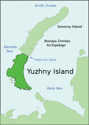
image caption =
image size = 200px
locator
Location map|Russia|lat=72|long=54
map_custom = yes
native name = Южный
native name link = Russian language
nickname =
location =Russia
coordinates = coord|72|N|54|E|type:isle_region:RU_scale:2000000|display=inline,title
archipelago =Novaya Zemlya
total islands =
major islands =
area = convert|33275|km2|sqmi|abbr=on
rank = 41st
length =
width =
highest mount =
elevation =
country = Russia
country admin divisions title = Oblast
country admin divisions =Arkhangelsk Oblast
country admin divisions title 1 =
country admin divisions 1 =
country admin divisions title 2 =
country admin divisions 2 =
country largest city =
country largest city population =
population =
population as of =
density =
ethnic groups =
additional info =Yuzhny ( _ru. Южный) is the southern island of the
Novaya Zemlya archipelago , lying north ofRussia . It has an area of 33,275 km², which while smaller than the northern island of Severny, makes it one of the largest islands in the world.Ecology
Originally home to the
Nenets people , the island was largely evacuated in the 1950s to make way fornuclear test s. [http://www-ns.iaea.org/downloads/rw/waste-safety/north-test-site-final.pdf]Yuzhny Island is known for its large
seabird population.The island's vegetation is largely composed of
tundra .References
* [http://worldmaps.web.infoseek.co.jp/russia_guide.htm Location]
* [http://www.bigarctic.ru/Eng Nature Reserve]

Wikimedia Foundation. 2010.