- Nordenskiöld Archipelago
-
Nordenskiöld Archipelago Native name: Russian: Архипелаг Норденшельда 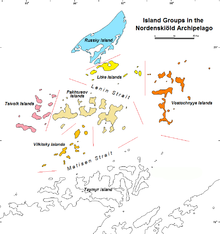
Distribution of the separate groups within the Nordenskiöld Archipelago.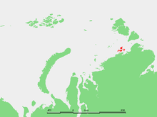
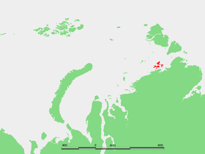
Location of the Nordenskiöld Archipelago in the Kara SeaGeography Location Archipelago Nordenskiöld Archipelago Country Demographics Population 0 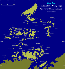 The Nordenskiöld Archipelago including some Siberian coastal islands.
The Nordenskiöld Archipelago or Nordenskjold Archipelago (Russian: Архипелаг Норденшельда or Arkhipelag Nordenshel'da) is a very large and complex cluster of islands in the eastern region of the Kara Sea. Its eastern limit lies 120 km (75 mi) west of the Taymyr Peninsula.
There are about 90 cold, windswept and desolate islands in this archipelago. These are mainly formed by igneous rocks and are covered with tundra vegetation. Except for two weather stations, one which was permanent in Russky Island between 1935 and 1999 and a temporary one in Tyrtov Island (Tyrtova) (1940-1975) there is no habitation in any island of the archipelago.
The Nordenskiöld Archipelago stretches for almost 100 km (62 mi) from west to east and about 90 km (56 mi) from north to south along the Kara Sea coastal region, off the Siberian shores, where there are large coastal islands (Taymyr Island, Nansena Island).
The Nordenskiöld Archipelago has been divided for geographical purposes into groups. The main groups are from west to east:
- Tsivolko Islands (острова Циволько; Ostrova Tsivolko) 76°44′N 94°38′E / 76.733°N 94.633°E is the westernmost group.
- Vilkitsky Islands (острова Вилькицкого, also Dzhekman Islands) 76°25′N 95°15′E / 76.417°N 95.25°E. The highest point of the archipelago (107 m) is located in Chabak Island, one of the Vilkitsky Islands.
- Pakhtusov Islands (острова Пахтусова; Ostrova Pakhtusova) 76°37′N 95°53′E / 76.617°N 95.883°E.
- Litke Islands (острова Литке; Ostrova Litke), 76°49′N 96°36′E / 76.817°N 96.6°E. This group includes Russky Island (остров Русский; Ostrov Russkiy) 77°03′N 96°09′E / 77.05°N 96.15°E. Located at the archipelago's northern end, this is the largest island of the Nordenskiöld group.
- Vostyochnyye Islands (Восточные острова; Vostyochnyye Ostrova, Eastern Islands), latitude 76° 38' N and longitude 97° 30' E. This group includes the Kolomeitsev Islands (острова Коломейцева; Ostrova Kolomeytseva) 76°56′N 97°48′E / 76.933°N 97.8°E.
The climate in the Nordenskiöld Archipelago is Arctic and severe. The sea surrounding the multitude of island groups is covered with fast ice in the winter and it is obstructed by pack ice even in the summer, which lasts only about two months in a normal year.
This island group belongs to the Krasnoyarsk Krai administrative division of Russia.
Contents
History
This archipelago was first reported in 1740 by Nikifor Chekin, who accompanied Semion Chelyuskin in the Great Northern Expedition. Many years later it was named after arctic explorer Adolf Erik Nordenskiöld by Norwegian polar explorer Fridtjof Nansen in his maps of the northern coasts and seas of Siberia.
In 1893, when Fridtjof Nansen's Fram was near the Nordenskjold Archipelago, it got stuck in dead water. This is a strange phenomenon that typically occurs in fjords, as glaciers melt and a form a shallow layer of freshwater ice over salty water. This is how Nansen described the phenomenon:
Towards the end of August 1893, when the "Fram" was off the Taymyr Peninsula, near the Nordenskiöld Archipelago, "dead water" was encountered. This is a peculiar phenomenon, which occurs where a surface layer of fresh water rests upon the salt water of the sea. It manifests itself in the form of larger or smaller ripples or waves stretching across the wake, the one behind the other, arising sometimes as far forward as almost midships. When caught in dead water, "Fram" appeared to be held back, as if by some mysterious force, and she did not always answer the helm. In calm weather, with a light cargo, "Fram" was capable of 6 to 7 knots. When in dead water she was unable to make 1.5 knots. We made loops in our course turned sometimes right around, tried all sorts of antics to get clear of it, but to very little purpose.
In 1900 the islands of the Nordenskiöld Archipelago were explored and mapped with accuracy by Captain Fyodor Andreyevich Matisen during the Russian Polar Expedition (1900 – 1903). This venture was led by Baron Eduard Von Toll on behalf of the Imperial Russian Academy of Sciences aboard ship Zarya. Toll sent Matisen to make a survey of the archipelago in the early spring while the Zarya was wintering close to Taymyr Island. Most islands of the Nordenskiöld Archipelago were charted and named during this effort. Matisen crisscrossed the whole vast frozen area on dogsled twice. He divided the archipelago into four of the five main groups mentioned above and named more than forty islands.
Like Nansen, Eduard Toll observed that it was difficult to navigate through the archipelago on account of the ice.[1]
After the Russian Revolution, the archipelago was explored in the 1930s by a Soviet expedition on the icebreaker Sedov.
In 1937 the Arctic Institute of the USSR organized an expedition on ship Toros. The purpose of this expedition was to explore the Nordenskiöld Archipelago and to thoroughly investigate the Northern Sea Route in the Kara Sea. The Toros overwintered in Ledyanaya Bay on Bonevi Island west of Taymyr Island and sailed back to Archangelsk during the summer thaw after having explored many Kara Sea islands.
On the 25th August 1942, during Operation Wunderland, Kriegsmarine cruiser Admiral Scheer fell upon the Russian icebreaker Sibiryakov]] (under the command of Captain Kacharev) off the northwest coast of Russky Island at the northern end of the Nordenskiöld Archipelago. The Sibiryakov resisted but was sunk by the German warship. Then Admiral Scheer headed southwest in order to attack the Soviet military installations at Dikson.
Since May 1993 the Nordenskiöld Archipelago is part of the Great Arctic State Nature Reserve, the largest nature reserve of Russia. The Arctic station at Russky Island was closed in 1999.
See also
- Fyodor Andreyevich Matisen
- Icebreaker Sedov
- Kara Sea
- List of islands of Russia
- Nansen's Fram expedition
- Operation Wunderland
References
- ^ William Barr, Baron Eduard Von Toll's Last Expedition., ARCTIC Sept 1980
External links
- All locations
- Valerian Albanov, In the Land of the White Death, 2001. Contains pictures of Fridtjof Nansen's early Arctic maps.
- On fast ice conditions near the Nordenskjold Archipelago
- Nature Reserve
- Consideration on geographic peculiarities on waterways of the Northern Sea Route
- Polar Exploration
Categories:

Wikimedia Foundation. 2010.