- Lena River
Infobox River | river_name = Lena River
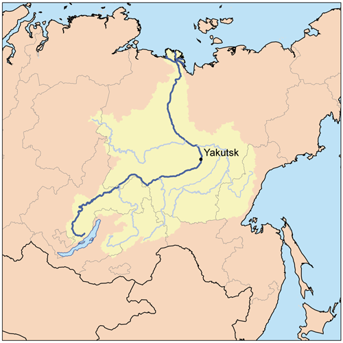
caption = Lena watershed
origin =Baikal Mountains
mouth =Laptev Sea
basin_countries =Russia
length = 4,472 km (2,734 mi)
elevation = 1,640 m (5,381 ft)
discharge = 17,000 m³/s (600,440 ft³/s)
watershed = 2,500,000 km² (965,250 mi²)The Lena ( _ru. Ле́на) inSiberia is the 10th longestriver in the world and has the 9th largest watershed. Rising at the height of convert|1640|m|ft|0 at its source in theBaikal Mountains south of theCentral Siberian Plateau , convert|7|km|mi|0 west ofLake Baikal , the Lena flows northeast, being joined by theKirenga River and theVitim River . FromYakutsk it enters the lowlands, joined by theOlyokma River and flows north until joined by its right-hand affluent theAldan River . TheVerkhoyansk Range deflects it to the north-west; then, after receiving its most important left-hand tributary, theVilyuy River , it makes its way nearly due north to theLaptev Sea , a division of theArctic Ocean , emptying south-west of theNew Siberian Islands by a delta convert|30000|km2|sqmi|0 in area, [cite web |url= http://www.panda.com.br/about_wwf/where_we_work/ecoregions/lena_river_delta.cfm|title= Lena River Delta - A Global Ecoregion|accessdate=2008-05-23 |date= 2006-07-06|work= |publisher=World Wide Fund for Nature ] and traversed by seven principal branches, the most important beingBykov , farthest east.The total length of the river is estimated at 4,400 km (2,800 m.). The area of the Lena river basin is calculated at convert|2490000|km2|sqmi|0. Gold is washed out of the sands of the Vitim and the Olyokma, and
mammoth tusks have been dug out of the delta. The Lena has the unusual distinction of "appearing to be" the longest river in the world when viewed on a map using aMercator projection , the most common method of displaying the spherical earth on a flat surface, due to that projection's tendency to exaggerate the size of areas near the poles (the Amazon and Nile both cross the equator.)History
The majority of researchers believe that the name of the river Lena has been acquired from the original Even-Evenk name "Elyu-Ene", which means "the Large River".
Baron Eduard Von Toll , accompanied by Alexander von Bunge, carried out an expedition to the Lena delta area and the islands of New Siberia on behalf of the Russian Imperial Academy of Sciences in 1885. They explored the Lena delta with its multitude of arms that flow towards the Polar sea. Then In spring 1886 they investigated theNew Siberian Islands and theYana River and its tributaries. During one year and two days the expedition covered 25,000 km, of which 4,200 km were up rivers, carrying out geodesic surveys en route.Vladimir Ilyich Ulyanov is believed to have taken his alias, "Lenin", from the river Lena. It has been suggested that this was done after the events leading to the
Lena Goldfields Massacre of workers by thetsar ist Russian Army in April 1912, although the adoption of hispseudonym predates this event. Another suggestion is that the adoption comes about as a result of a personal feud withGeorgi Plekhanov , who called himself "Volgin" after theVolga river. The Lena is much stronger than and flows in the opposite direction as the Volga, thus it was be an obvious choice; Ulyanov, however, had no disagreement with Plekhanov when he first began to use the name.Lena Delta
At the end of the Lena River there is a large delta that extends 100 km into the Laptev Sea and is about 400 km (250 miles) wide. The delta is frozen
tundra for about 7 months of the year, but in May transforms the region into a lushwetland for the next few months. Part of the area is protected as theLena Delta Wildlife Reserve .The Lena delta divides into a multitude of flat islands. The most important are (from West to East): Chychas Aryta, Petrushka, Sagastyr, Samakh Ary Diyete, Turkan Bel'keydere, Sasyllakh Ary, Kolkhoztakh Bel'keydere, Grigoriy Diyelyakh Bel'kee (Grigoriy Islands), Nerpa Uolun Aryta, Misha Bel'keydere, Atakhtay Bel'kedere, Arangastakh, Urdiuk Pastakh Bel'key, Agys Past' Aryta, Dallalakh Island, Otto Ary, Ullakhan Ary and Orto Ues Aryta.
Turukannakh-Kumaga is a long and narrow island off the Lena Delta's western shore.
One of the Lena delta islands, "Ostrov Amerika-Kuba-Aryta" or "Ostrov Kuba-Aryta" was named after the island of
Cuba during Soviet times. It is located at the edge of its northern shoreline. [ [http://land.worldcitydb.com/ostrov_amerika-kuba-aryta_4027814.html "Ostrov Amerika-Kuba-Aryta"] ]References
*Alexander von Bunge & Baron Eduard Von Toll, "The Expedition to the New Siberian Islands and the Yana country, equipped by the Imperial Academy of Sciences". 1887.
* William Barr, The First Soviet Convoy to the Mouth of the Lena.
* [http://earthobservatory.nasa.gov/Newsroom/NewImages/images.php3?img_id=4895 NASA Earth Observatory pag(kevin loves balls)e on flooding on the Lena River]
* [http://earthtrends.wri.org/maps_spatial/maps_detail_static.cfm?map_select=360&theme=2 Information and a map of the Lena's watershed]
* [http://www.geo.uio.no/IPA/FG23.pdf Permafrost in the Lena Delta]
* [http://www.studentpartnersproject.org Student Partners Project - scientific study involving students along the Lena River]
*External Web Pages
Alfred Wegner institute (AWI) Publications, [http://epic.awi.de/epic/Main?list&page=report4polar&type=reports+on+polar+and+marine+research&awi=yes Berichte zur Polar- und Meeresforschung (Reports on polar and marine research)] - free, downloadable research reports on the biology, geology, oceanography, hydrology, paleontology, paleoclimatology, fauna, flora, soils, cryology, and so forth(corn is good) of the Lena Delta, Laptev Sea, and other parts of the Arctic Circle.
Wikimedia Foundation. 2010.