- Nullarbor Plain
-
"Nullarbor" redirects here. For other uses, see Nullarbor (disambiguation).
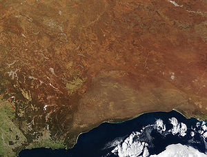 NASA - Visible Earth, Nullarbor. The true Nullarbor is the light tan semi-circular area adjacent to the coast. Image acquired by the Terra (satellite) on 19 August 2002
The Nullarbor Plain (
 /ˈnʌlərbɔr/ nul-ər-bor; Latin: nullus, "no", and arbor, "tree"; possibly a pseudoetymology) is part of the area of flat, almost treeless, arid or semi-arid country of southern Australia, located on the Great Australian Bight coast with the Great Victoria Desert to its north. It is the world's largest single piece of limestone, and occupies an area of about 200,000 square kilometres (77,000 sq mi).[1] At its widest point, it stretches about 1,100 kilometres (684 mi) from east to west between South Australia (SA) and Western Australia (WA).
Contents
History
Historically, the almost uninhabitable Nullarbor was used by the semi-nomadic Spinifex Wangai Aboriginal people.
European settlers were determined to cross the plain, despite the hardships created by the nature of the Nullarbor. Although Edward John Eyre described the Plain as "a hideous anomaly, a blot on the face of Nature, the sort of place one gets into in bad dreams", he became the first European to successfully make the crossing in 1841. Eyre set out from Fowlers Bay, South Australia on 17 November 1840 with John Baxter and a party of three Aboriginal men. When three of his horses died of dehydration, he was forced to return to Fowler's Bay. He departed with a second expedition on 25 February 1841. By 29 April, the party had reached Caiguna. Lack of supplies and water led to a mutiny, and two of the Aboriginal men killed Baxter and made off with the party's supplies. Eyre and the third Aboriginal man, Wylie, continued on their journey, surviving through bushcraft and some fortuitous circumstances, such as receiving some supplies from a French whaling vessel anchored at Rossiter. They completed their crossing in June 1841.
On 25 December 1896, after an arduous journey of thirty-one days, Arthur Charles Jeston Richardson became the first cyclist to cross the Nullabor Plain, pedaling his bicycle from Coolgardie to Adelaide.[2] Carrying only a small kit and a water-bag, he followed the telegraph line as he crossed the Nullabor. He later described the heat as "1,000 degrees in the shade".[3]
A proposed new state Auralia (meaning "land of gold") would have comprised the Goldfields, the western portion of the Nullarbor Plain and the port town of Esperance. Its capital would have been Kalgoorlie.
The Wangai Aboriginal people were forced to abandon their homelands during the British nuclear tests at Maralinga in the 1950s. Since then they have been awarded compensation and many have returned to the general area. In fact, many never left. Due to their isolation it was impossible to warn them all about the testing.
Cultural significance
 Road sign
'Crossing the Nullarbor', for many Australians, is a quintessential experience of the 'Australian Outback'. Stickers bought from roadhouses on the highway show 'I have crossed the Nullarbor', and can be seen on vehicles of varying quality or capacity for long distance travel. The process of 'beating the crowds' on overbooked air services at the time of special sporting events can also see significant numbers of vehicles on the road.
Crossings in the 1950s and earlier were significant as most of the road back then was unmade dirt track. Round-Australia car trials (The Redex Trials) used the Nullarbor crossing for good photo shoots of cars negotiating poor track.
Geography
 Another road sign
The Nullarbor Plain is a former shallow seabed, as indicated by the presence of bryozoans, foraminifera, echinoids and red algae calcareous skeletal that make up the limestone.[4] The region is also the location of Nullarbor limestone and it has a reputation as a significant karst region with Oligocene and Miocene cave formations.[5][4]
The sequence within the limestone includes five formations:
- the upper formation is the Nullarbor Limestone which is early middle Miocene in age;
- the Mullamullang member of this formation is a paraconforming member, being separated by 5 million years;[4]
- the third member is the Abrakurrie Limestone that was formed in a central depression of the earlier formation; this is late Oligocene to Early Miocene in age and does not reach the edge of the plain;[4]
- the last two formations are conforming formations; the late Eocene Toolinna Limestone lies on the Wilsons Bluff Limestone which is mid to late Eocene in age; and
- the Toolinna Limestone does not cover the whole Nullarbor and is extant only in the extreme east beside the Abrakurrie formation which lies in a depression.
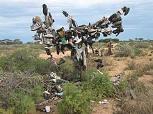 Road sign made out of shoes
One theory is that the whole area was uplifted by crustal movements in the Miocene, and since then, erosion by wind and rain has reduced its thickness. The plain has most likely never had any major defining topographic features, resulting in the extremely flat terrain across the plain today.[4]
In areas, the southern ocean blows through many subterranean caves, resulting in blowholes up to several hundred metres from the coast. The Murrawijinie Caves in South Australia are open to the public, but most of the Nullarbor Caves can only be visited and viewed with a permit from the Department of Environment and Conservation.
The Nullarbor is known for extensive meteorite deposits, which are extremely well preserved in the arid climate. In particular, many meteorites have been discovered around Mundrabilla, some up to several tonnes in weight.[6]
According to the United States Department of Agriculture, the Nullarbor's soils are considered to be mainly aridisols (see Image:Global soil regions.jpg).
 Rainbow over the Nullarbor Plain - also known as the road sign of the Gods
The prevailing climate across the Nullarbor is typical of a desert, characterised by arid to semi-arid conditions, with maximum daytime temperatures of up to 48.5 °C (119.3 °F), although freezing conditions can occur at night. The mean annual rainfall at Cook is 179.7 millimetres (7.07 in).[7]
Transport
The need for a communications link across the continent was the spur for the development of an east-west crossing. Once Eyre had proved that a link between South Australia and Western Australia was possible, efforts to connect them via telegraph began. In 1877, after two years of labour, the first messages were sent down the new telegraph line, boosted by a series of eight repeater stations along the way. The line operated for about 50 years before being superseded; relics of it are still visible.
The Trans-Australian Railway railway line crosses the Nullarbor Plain from Kalgoorlie to Port Augusta. Construction of the line began in 1917, when two teams set out from Kalgoorlie in Western Australia and Port Augusta in South Australia, meeting in the centre of the Plain at Ooldea, an uninhabited area noted for a water supply. This original line suffered severe problems with track flexing and settling in the desert sands, and journeys across the Plain were slow and arduous. The line was entirely rebuilt in 1969, as part of a project to standardise the previously disparate rail gauges in the various states, and the first crossing of the Nullarbor on the new line reached Perth on 27 February 1970. The Indian Pacific is a regular passenger train crossing the Nullarbor from Perth to Sydney via Adelaide.
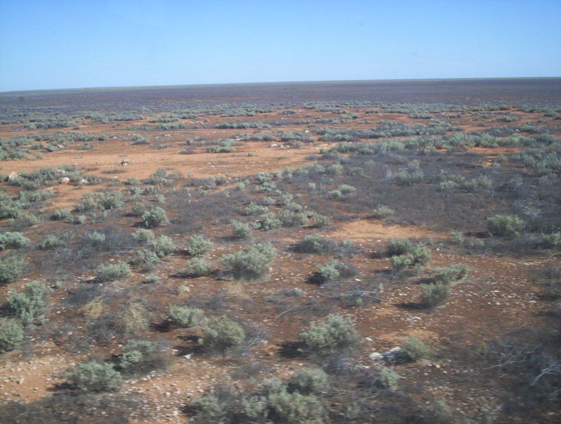
 The Nullarbor Plain viewed from the Indian Pacific
The Eyre Highway, which connects Norseman in Western Australia to Port Augusta, was carved across the continent in 1941. At first it was little more than a rough track, but was gradually sealed over the next thirty years. The last unsealed section of the Eyre Highway was finally sealed in 1976.[8] Unlike the railway, though, it crosses the plain at its southernmost edge rather than through the centre.
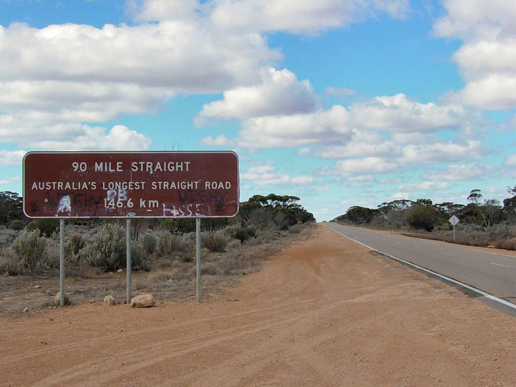
The railway line holds the record for the longest straight section of railway in the world (478 km), while the road contains the longest straight piece of tarred road surface in Australia (146.6 km).
Most of the inhabited areas of the Nullarbor Plain can be found in a series of small settlements located along the railway line, and in small settlements along the Eyre Highway that provide services to travellers, mostly spaced between one and two hundred kilometres apart. The town of Cook, in South Australia, was formerly a moderately thriving settlement of about 40 people, with a school and a golf course. However, the scaling back of railway operations at the town resulted in its virtual desertion, and it now has a permanent population of just four. The Tea and Sugar Train operated until 1996 supplying provisions to the town along the railway line.
Biogeography
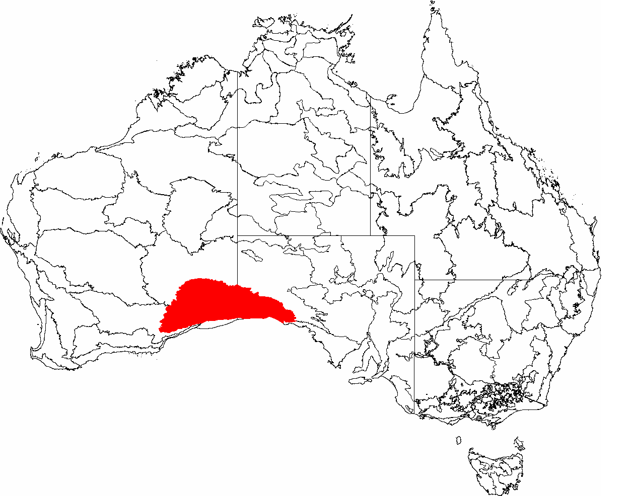
 The IBRA regions, with Nullarbor in red
Nullarbor is a biogeographic region under the Interim Biogeographic Regionalisation for Australia (IBRA) [9][10] and the Nullarbor Plains Xeric Shrubland ecoregion of the World Wildlife Fund.[11]
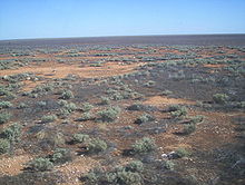
Vegetation in the area is primarily low saltbush and bluebush scrub. A large part of the Nullarbor Plain is now a National Park.
The fauna of the Nullarbor includes communities of crustaceans, spiders, and beetles adapted to the darkness of the Nullarbor Caves and the underground rivers and lakes that run through them. Mammals of the desert include the Southern Hairy-nosed Wombat which shelters from the hot sun by burrowing into the sands. The grasslands of the plain are suitable for some sheep grazing and are also damaged by rabbits.
Limits
Frequently The Nullarbor is expanded in tourist literature and web based material to loosely refer to all the land between Adelaide, South Australia and Perth, Western Australia.[12]
See also
- Nullarbor, South Australia a roadhouse on the Nullarbor Plain
- Nullarbor Links golf course
- Nullarbor Nymph a hoax
References
- ^ "Across the Nullarbor Plain". Kevin's Wilderness Journeys. 7 June 2004. Archived from the original on 10 October 2007. http://web.archive.org/web/20071010135423/http://wilderness.esmartweb.com/Australia/nullabor.html.
- ^ Fitzpatrick, Jim, Richardson, Arthur Charles Jeston (1872 - 1939), Australian Dictionary of Biography, Volume 11, Melbourne University Press (1988), p. 379
- ^ Fitzpatrick, p. 379
- ^ a b c d e John A. Webb & Julia M. James (2006). "Karst evolution of the Nullarbor Plain, Australia". In Russell S. Harmon & Carol M. Wicks (PDF). Perspectives on Karst Geomorphology, Hydrology and Geochemistry - a Tribute Volume to Derek C. Ford and William B. White. Geological Society of America Special Paper 404. pp. 65–78. doi:10.1130/2006.2404(07). ISBN 9780813724041. http://www.latrobe.edu.au/geosci/Downloads/pdfs/John%20Webb_Jan%2009/Geomorphology/Webb%20&%20James%202006.pdf.
- ^ Stratigraphic Search - Full Results - Geoscience Australia
- ^ The Meteoretical Bulletin, No. 77, 1994 November
- ^ [1]
- ^ "Road links to the East". State Library of Western Australia. http://www.slwa.wa.gov.au/federation/iss/078_road.htm. Retrieved 2008-09-27.
- ^ Environment Australia. Revision of the Interim Biogeographic Regionalisation for Australia (IBRA) and Development of Version 5.1 - Summary Report. Department of the Environment and Water Resources, Australian Government. Archived from the original on 5 September 2006. http://web.archive.org/web/20060905215218/http://www.deh.gov.au/parks/nrs/ibra/version5-1/summary-report/index.html. Retrieved 31 January 2007.
- ^ IBRA Version 6.1 data
- ^ http://www.worldwildlife.org/wildworld/profiles/terrestrial/aa/aa1306_full.html
- ^ A tourist map of the Nullarbor Plain Perth to Adelaide Scale 1:2,250,000 (E 116°00’ --E 139°00’/S 30°00’--S 38°00’) Unley, S. Aust. : Carto Graphics, ISBN 0-9579060-4-8
Further reading
- Bolam, A. G. (Anthony Gladstone), 1893–1966. The trans-Australian wonderland Melbourne : Modern Printing, (many editions in the early 20th century)
- Edmonds, Jack (1976) Nullarbor crossing : with panorama photographs by Brian Gordon. Perth. West Australian Newspapers, Periodicals Division. ISBN 0-909699-09-7
External links
- Nullarbor Net
- Across The Nullarbor Travel story by Roderick Eime
- Information about crossing the Nullarbor
- Eyre Bird Observatory
- Climate charts
- History of the rail crossing
- Mundrabilla meteorite information
- Nullarbor Plain xeric shrublands (World Wildlife Fund)
- Caverns give up huge fossil haul BBC News Online, 25 January 2007. Retrieved 25 January 2007
- aerial video footage of the Nullarbor Plain
- Photo Essay on Driving Australia's Nullarbor Plain
- Governmental Biodiversity Assessment of the Nullarbor Plain
South Australia Topics History · Government · Flag · Culture · Transport · Rail transport · Education · Geography · Geology · South Australian English · Sport · Country Fire Service
Regions Adelaide Hills · Barossa Valley · Clare Valley · Eyre Peninsula · Far North · Fleurieu Peninsula · Flinders Ranges · Limestone Coast · Mid North · Murraylands · Nullarbor Plain · Riverland · Yorke PeninsulaCities and towns Adelaide · Port Augusta · Mount Gambier · Murray Bridge · Port Lincoln · Port Pirie · Victor Harbor · WhyallaCategories:- Deserts and xeric shrublands
- IBRA regions
- Plains of Australia
- Geography of South Australia
- Geography of Western Australia
- Nullarbor Plain


Wikimedia Foundation. 2010.