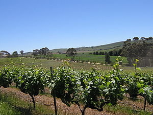
- Clare Valley
-
Clare Valley (wine region) 
Country Australia Sub-regions Polish Hill Valley Size of planted vineyards 40 km2 (15.4 sq mi) Grapes produced Riesling, Shiraz, Cabernet Sauvignon - See also Clare Valley (disambiguation).
The Clare Valley is one of Australia's oldest wine regions, best known for Riesling wines. It lies in the Mid North of South Australia, approximately 120 km north of Adelaide. The valley runs north-south, with Main North Road as the main thoroughfare.
Contents
History
Pre-European settlement
The original inhabitants of the Clare Valley were the Ngadjuri people. It is believed that they had major camping sites at Clare and Auburn, as well as other areas outside the valley.[1]
European settlement
The first European to reportedly explore the region was William John Hill, who arrived in South Australia on the HMS Buffalo in 1836. He was a surveyor and explored the Clare Valley district in 1838,[2] discovering and naming the Hutt River. The Hill River was later discovered and named in his honour. On returning to Adelaide, he reported his findings of potentially good farmland to his friend and associate, Edward John Eyre. Eyre in turn informed John Horrocks, who had only arrived in the new colony in March 1839. Eyre later explored the Clare Valley on the return journey from his second 1839 expedition to the northern regions of South Australia. Horrocks set out with his servant, John Green and established himself in the area now known as Penwortham. This became the first permanent settlement in the valley. By 1840, Edward Burton Gleeson had set up the Inchiquin pastoral run to the north which was later developed into the town of Clare and in 1848, Jesuits were settling into the place which would become the town of Sevenhill. Settlers from England and Ireland, as well as more diverse places such as Poland and Silesia continued to progress into the region during the 1840s, producing a rich heritage of architecture and villages, which remain largely intact. Vineyards were planted alongside those first villages and winemaking has continued ever since.
Modern times
On 16 February 1983, the Clare Valley was devastated by bushfires during the Ash Wednesday disaster. Although there were no fatalities in the area, over 6,100 hectares were burnt out, causing $5 million worth of damage.[3] The railway line between the Clare Showgrounds and Penwortham was severely damaged, and resulted in its eventual demise. The old rail route has since been transformed into a popular bicycle riding track known as the Riesling Trail. This 35km sealed trail links the villages of the valley.
Soil and climate
The wines are planted from 400 to 500 metres (1,300 to 1,600 ft).[4] The climate is moderately continental, with cool to cold nights and warm to hot summer days. The higher altitude, compared to other wine regions in South Australia, ensures cool nights even during the heat of summer allowing the fruit to ripen more evenly and slowly. Rainfall is predominantly in winter - spring (June - September) with an annual average of around 630 mm. Summers are dry and make irrigation desirable but also ensure a minimum of fungal diseases. Varied soil types throughout the valleys are another feature, ranging from red to brown grey over basement rock.
Grape varieties
The most important white variety is Riesling, with the Clare Valley regarded as its Australian home.
Principal red varieties are Cabernet Sauvignon and Shiraz. They make a range of styles of varietal wines, reflecting different approaches to winemaking as well as the influences of the various sub-regions and micro-climates in the valleys.
Regional facts
The region has more than 40 wineries, most of which are small and produce only bottled wine.
- Area planted: 40 km²
- Annual production: 1999: - 19,694, 2000:- 12,444
See also
- Australian wine
- South Australian wine
- List of wineries in the Clare Valley
References
- ^ Noye, Robert J. (1980). CLARE – A District History. Hawthorndene, South Australia: Investigator Press. pp. 216–218.
- ^ Stratton, J., (ed) (1986). Biographical Index of South Australians 1836 – 1885 Volume II. Adelaide, South Australia: SA Genealogy and Heraldry Society. p. 741.
- ^ "26 years on, Clare remembers Ash Wednesday". ABC North and West SA. http://www.abc.net.au/local/stories/2009/02/16/2492489.htm. Retrieved 2009-06-19.
- ^ Oz, Clark. Australian Wine Companion. Time Warner Books. pp. 54–57.
External links
Coordinates: 33°53′S 138°36′E / 33.883°S 138.6°E
Wine regions of South Australia Adelaide Hills · Adelaide Plains · Barossa Valley · Clare Valley · Coonawarra · Currency Creek · Eden Valley · Kangaroo Island · Langhorne Creek · McLaren Vale · Mount Benson · Padthaway · Riverland · Southern Fleurieu · Southern Flinders Ranges · The Peninsulas · Wrattonbully
South Australia Topics History · Government · Flag · Culture · Transport · Rail transport · Education · Geography · Geology · South Australian English · Sport · Country Fire Service
Regions Adelaide Hills · Barossa Valley · Clare Valley · Eyre Peninsula · Far North · Fleurieu Peninsula · Flinders Ranges · Limestone Coast · Mid North · Murraylands · Nullarbor Plain · Riverland · Yorke PeninsulaCities and towns Adelaide · Port Augusta · Mount Gambier · Murray Bridge · Port Lincoln · Port Pirie · Victor Harbor · WhyallaSouth Australia portal Categories:- Wine regions of South Australia
- Mid North (South Australia)
Wikimedia Foundation. 2010.
