- Central Basin and Range ecoregion
-
This article is about the ecoregion designated by the EPA. For the associated United States physiographic region, see Great Basin section.

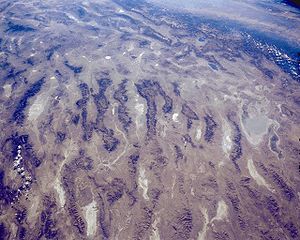
Central Basin and Range from space
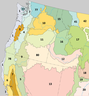
Central Basin and Range ecoregion (13)Ecology Ecozone Nearctic Biome North American Desert Borders Northern Basin and Range (ecoregion) (80), Sierra Nevada (ecoregion) (5) and Wasatch and Uinta Mountains (ecoregion) (19) Geography Country United States States Nevada, Utah, California and Idaho The Central Basin and Range ecoregion is a Level III ecoregion designated by the United States Environmental Protection Agency (EPA) with 26 different Level IV ecoregions.[1] Its northern boundary is determined by the highest historical shoreline of Pleistocene Lake Bonneville.
Central Basin and Range
Level IV ecoregionscode 13a Salt Deserts 13b Shadscale-Dominated Saline Basins 13c Sagebrush Basins
Sagebrush Slopes13d Woodland Low Mountains
Shrub-Covered Low Mountains13e Carbonate High Elevation Mountains 13g Wetlands 13h Lahontan Playas
Tonopah Playas13j Lahontan Salt Shrub Basin 13k Lahontan Sagebrush Slopes 13l Lahontan Uplands 13m Upper Humboldt Plains 13n Mid-Elevation Ruby Mountains 13o High Elevation Ruby Mountains 13p Carbonate Sagebrush Valleys 13q Carbonate Woodland 13r Central Nevada High Valleys 13s Central Nevada Mid-Slope Woodland
Central Nevada Mid-Slope Brushland13t Central Nevada Bald Mountains 13u Tonopah Basin 13v Tonopah Sagebrush Foothills 13w Tonopah Uplands 13x Sierra Nevada-Influenced Ranges 13y Sierra Nevada-Influenced High Elevation Mountains 13z Upper Lahontan Basin 13aa Sierra Nevada-Influenced Semiarid Hills
Sierra Nevada-Influenced Semiarid BasinsReferences
- ^ Bryce, S.A; et. al (poster), Ecoregions of Nevada, Reston, Virginia: USGS
Categories:- Central Basin and Range ecoregion
- Ecoregions of the United States
- Ecology of the Great Basin
Wikimedia Foundation. 2010.
