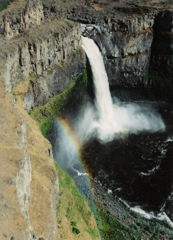
- Palouse Falls
Infobox Waterfall
name = Palouse Falls
image_size = 240px
caption = Palouse Falls
location =Franklin County, Washington /Whitman County, Washington
coordinates = coord|46|39|49|N|118|13|25|W|display=inline,title
elevation = convert|725|ft|m|abbr=on
type =
height = convert|198|ft|m|abbr=on
width =
height_longest =
average_width =
number_drops =
average_flow =
watercourse =
world_rank =
footnotes = [http://geonames.usgs.gov/pls/gnispublic/f?p=gnispq:3:::NO::P3_FID:1510548 Palouse Falls, 1510548]Geographic Names Information System The Palouse Falls lies on thePalouse River , about 4 miles upstream of the confluence with theSnake River in southeastWashington . The falls are 56 meters in height. The canyon at the falls is 115 meters (377 feet) deep, exposing a large cross-section of theColumbia River Basalt Group . These falls and the canyon downstream comprise an important feature of the channeled scablands created by the greatMissoula Floods that swept periodically across eastern Washington and across theColumbia River Plateau during the Pleistocene epoch.cite book|author=Carson, Robert J. and Pogue, Kevin R.|title=Flood Basalts and Glacier Floods:Roadside Geology of Parts of Walla Walla, Franklin, and Columbia Counties, Washington |publisher=Washington State Department of Natural Resources (Washington Division of Geology and Earth Resources Information Circular 90)|year=1996|id=ISBN none ] cite book|first=David|last=Alt|id=ISBN 0-87842-415-6|location= |title=Glacial Lake Missoula & its Humongous Floods|publisher=Mountain Press Publishing Company ] cite book|author=Bjornstad, Bruce|title=On the Trail of the Ice Age Floods: A Geological Guide to the Mid-Columbia Basin |publisher=Keokee Books; Sand Point, Idaho |year=2006|id=ISBN 978-1-879628-27-4] .The ancestral Palouse river flowed through the currently dry Washtucna Coulee to the
Columbia River . The Palouse Falls and surrounding canyons were created when theMissoula Floods overtopped the south valley wall of the ancestral Palouse River, diverting it to the current course to theSnake River by erosion of a new channel.cite book|author=Alt, David and Hyndman, Donald|id=ISBN 0-87842-160-2|location= |title=Roadside Geology of Washington|year=1984|publisher=Mountain Press Publishing Company ]The area is characterized by interconnected and hanging flood-created coulees, cataracts, plunge pools,
kolk created potholes, rock benches, buttes and pinacles typical of scablands. Palouse Falls State Park is located at the falls, protecting this part of the uniquely scenic area.In 1984 the Franklin County Public Utilities District proposed a 30 meters high dam be constructed upstream of the falls, allowing for a significant hydraulic head for hydro-electricity power generation. This would have provided over 1/3 of the counties power and would have reduced ratepayer charges substantially. However the majority of the ratepayers declined to approve the investment, preserving this geologically significant feature.
References
External links
* [http://www.parks.wa.gov/parkpage.asp?selectedpark=Palouse%20Falls Palouse Falls State Park] , Washington State Parks
* [http://picturethis.pnl.gov/PictureT.nsf/All/6D82FP?opendocument Photo of the falls] ,Pacific Northwest National Laboratory
Wikimedia Foundation. 2010.