- Columbia Basin Project
-
 The Columbia Basin Irrigation Project
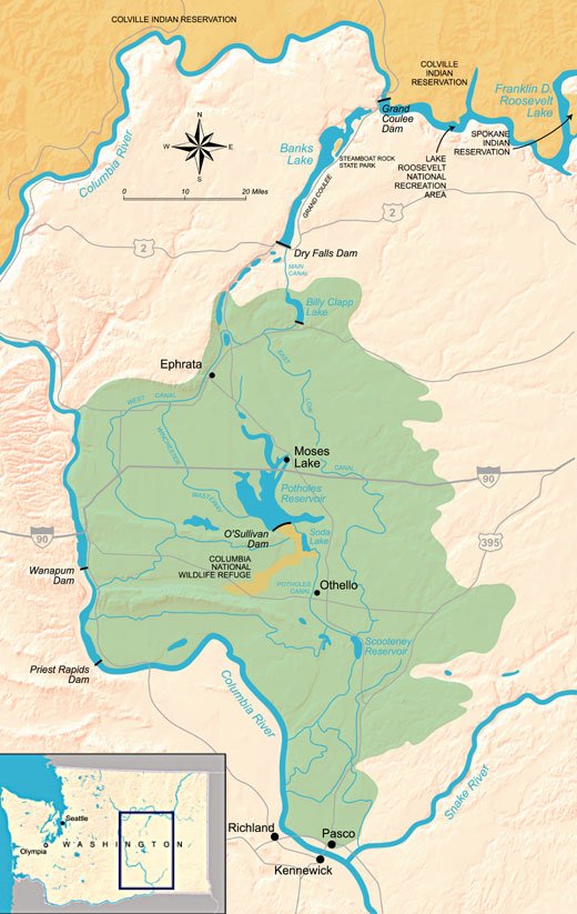
The Columbia Basin Project (or CBP) in Central Washington, USA, is the irrigation network that the Grand Coulee Dam makes possible. It is the largest water reclamation project in the United States, supplying irrigation water to over 670,000 acres (2,700 km2) of the 1,100,000 acres (4,500 km2) large project area, all of which was originally intended to be supplied and is still classified as irrigable and open for the possible enlargement of the system. Water pumped from the Columbia River is carried over 331 miles (533 km) of main canals, stored in a number of reservoirs, then fed into 1,339 miles (2,155 km) of lateral irrigation canals,[1] and out into 3,500 miles (5,600 km) of drains and wasteways.[2]
Contents
History
The U.S. Bureau of Reclamation was created 1902 to aid development of dry western states. Central Washington's Columbia Plateau was a prime candidate—a desert with fertile loess soil and the Columbia River passing through.
Competing groups lobbied for different irrigation projects; a Spokane group wanted a 134 miles (216 km) gravity flow canal from Lake Pend Oreille while a Wenatchee group (further south) wanted a large dam on the Columbia River, which would pump water up to fill the nearby Grand Coulee, a formerly-dry canyon-like coulee.
After thirteen years of debate, President Franklin D. Roosevelt authorized the dam project. Construction of Grand Coulee Dam began in 1933 and was completed in 1942. Its main purpose of pumping water for irrigation was postponed during World War II in favor of electrical power generation that was used for the war effort. Additional hydroelectric generating capacity was added into the 1970s. The Columbia River reservoir behind the dam was named Franklin Delano Roosevelt Lake in honor of the president. The irrigation holding reservoir in Grand Coulee was named Banks Lake.
After World War II the project suffered a number of setbacks. Irrigation water began to arrive between 1948 and 1952, but the costs escalated, resulting in the original plan, in which the people receiving irrigation water would pay back the costs of the project over time, being repeatedly revised and becoming a permanent water subsidy. In addition, the original vision of a social engineering project intended to help farmers settle on small landholdings failed. Farm plots, at first restricted in size, became larger and soon became corporate agribusiness operations.[1]
The original plan was that a federal agency similar to the Tennessee Valley Authority would manage the entire system. Both the Bureau of Reclamation and the Department of Agriculture sought to gain control as the primary administrative agency, and both pressed their own plan for doing so. The rivalry between them was ultimately so paralyzing that a power vacuum was created. Neither agency gain control and large private interests prevailed instead. As a result the original vision lost its cohesive focus and corporate interests gained as the main beneficiaries.[1]
The determination to finish the project's plan to irrigate the full 1,100,000 acres (4,500 km2) waned during the 1960s. The estimated total cost for completing the project had more than doubled between 1940 and 1964, it had become clear that the government's financial investment would not be recovered, and that the benefits of the project were unevenly distributed and increasingly going to larger businesses and corporations. These issues and others dampened enthusiasm for the project, although the exact motives behind the decision to stop construction with the project about half finished are not known.[1]
Geology
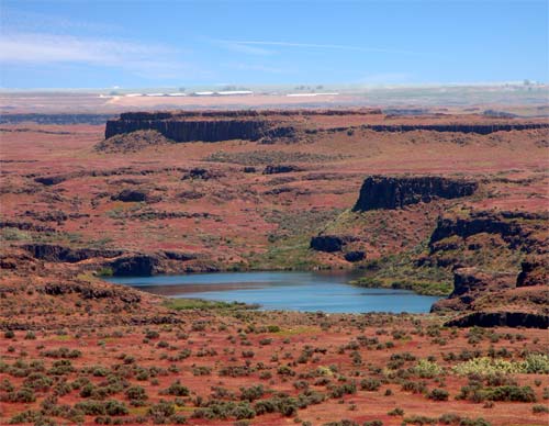
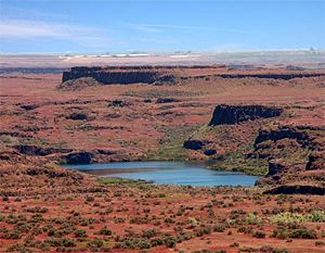 Drumheller Channels, 10 miles (16 km) south of Potholes Reservoir, are examples of channeled scablands
The Columbia Basin in Central Washington is fertile due to its loess soils, but large portions are a near desert, receiving less than ten inches (254 mm) of rain per year. The area is characterized by huge deposits of flood basalt, thousands of feet thick in places, laid down over a period of approximately 11 million years, during the Miocene epoch.[3] These flood basalts are exposed in some places, while in others they are covered with thick layers of loess.
During the last ice age glaciers shaped the landscape of the Columbia River Plateau. Ice blocked the Columbia River near the north end of Grand Coulee, creating glacial lakes Columbia and Spokane. Ice age glaciers also created Glacial Lake Missoula, in what is now Montana. Erosion allowed glacial Lake Columbia to begin to drain into what became Grand Coulee, which was fully created when glacial Lake Missoula along with glacial Lake Columbia catastrophically emptied.[4] This flood event was one of several known as the Missoula Floods. Unique erosion features, called channeled scablands, are attributed to these amazing floods.
Irrigation of the Columbia Basin
When it was built, Grand Coulee Dam was the largest dam in the world, but it was only part of the irrigation project. Additional dams were built at the north and south ends of Grand Coulee, the dry canyon south of Grand Coulee Dam, allowing the coulee to be filled with water pumped up from the Columbia River. The resulting reservoir, called Banks Lake, is about 30 miles (48 km) long. Banks Lake serves as the CBP's initial storage reservoir. Additional canals, siphons, and reservoirs were built south of Bank Lake, reaching over 100 miles (160 km). Water is lifted 280 feet (85 m) from Lake Roosevelt to feed the massive network.
Two and three percent of the Columbia's flow is currently diverted at the Grand Coulee Dam. The amount of water annually diverted into the CBP and used for irrigation is larger than the entire annual flow of the Colorado River.[1] There are plans to double the area of irrigated land, according to tour guides at the dam, over the next several decades. However, the Bureau of Reclamation website states that no further development is anticipated, with 671,000 acres (2,720 km2) irrigated out of the original 1,100,000 acres (4,500 km2) planned.[5]
Interest in completing the Columbia Basin Project's 1,100,000 acres (4,500 km2) has grown in the late 20th and early 21st centuries. One reason for the renewed interest is the substantial depletion of the Odessa aquifer. Agricultural operations within the CBP's boundaries but outside the developed portion have for decades used groundwater pumped from the Odessa aquifer to irrigate crops.[1]
Unintended consequences
Hydroelectricity was not the primary goal of the project, but during World War II the demand for electricity in the region boomed. The Hanford nuclear reservation was built just south of the project and aluminum smelting plants flocked to the Columbia Basin. A new power house was built at the Grand Coulee Dam, starting in the late sixties, that tripled the generating capacity. Part of the dam had to be blown up and re-built to make way for the new generators. Electricity is now transmitted to Canada and as far south as San Diego.
There are a number of issues regarding the runoff of irrigation water. The project region receives about 6 to 10 inches (250 mm) of annual rainfall, while the application of irrigation water amounts to an equivalent 40 to 50 inches (1,300 mm). The original plans did not sufficiently address the inevitable seepage and runoff.[1] In some cases the results are beneficial. For example, numerous new lakes provide recreation opportunities and habitat for fish and game. In other cases agricultural chemical in the runoff cause pollution.
Environmental impact
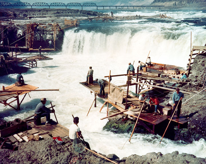
The most prominent negative environmental impact has been the reduction in native fish stocks above the dams. The majority of fish in the Columbia basin are migratory fish like salmon, sturgeon and steelhead. These migratory fish are often destroyed or unable to pass through the narrow passages and turbines at dams. In addition to the physical barriers the dams pose, the slowing speed and altered course of the river raises temperatures, alters oxygen content, and changes river bed conditions. These altered conditions can stress and potentially kill both migratory and local non-migratory organisms in the river. The decimation of these migratory fish stocks has been especially dire for many of the Native Americans of the Pacific Northwest who depended on the salmon for a way of life.
The negative environmental impacts of the Columbia Basin Project have made it a contentious and often politicized issue. A common argument for not implementing environmental safeguards at dam sites is that post-construction modifications would likely have to be significant. Tour guides at the Grand Coulee dam site, for example, indicate that a "fish ladder might have to be 5 miles (8.0 km) long to get the fish up the 550 feet (170 m) needed, and many fish would die before reaching the upper end" thus no fish ladders were built. Advocates of remedial measures point out that such steps would still be better than the status quo, which has led to marked die-offs and the likely extinction[6] of several types of salmon.
The massive amounts of irrigation water provided by this project greatly benefits the agricultural production of the area. North Central Washington is one of the largest and most productive tree fruit producing areas on the planet. Without Coulee Dam and the greater Columbia Basin Project, much of North Central Washington State would be too arid for cultivation.
Economic benefits and costs
According to the federal Bureau of Reclamation the yearly value of the Columbia Basin Project is $630 million in irrigated crops, $950 million in power production, $20 million in flood damage prevention, and $50 million in recreation.[7] The project itself involves costs that are difficult to determine. The farms that receive irrigation water must pay for it, but due to insufficient data from the Bureau of Reclamation it is not possible to compare the total cost paid by the Bureau to the payments received. Nevertheless, the farm payments account for only a small fraction of the total cost to the government, resulting in a the project's agricultural corporations receiving a large water subsidy from the government.[1] Critics describe the CBP as a classical example of federal money being used to subsidize a relatively small group of private special interest irrigation farming in the American West in places where it would never be economically viable under other circumstances.[1]
See also
- Tributaries of the Columbia River
- Cities on the Columbia River
- Hydroelectric dams on the Columbia River
References
- ^ a b c d e f g h i Bloodworth, Gina; James White (2008). "The Columbia Basin Project: Seventy-Five Years Later". Yearbook of the Association of Pacific Coast Geographers 70 (Annual 2008): pp. 96–111. ISSN 0066-9628. http://www.gale.cengage.com/. Retrieved 25 October 2009.
- ^ "Project details - Columbia Basin Project". United States Bureau of Reclamation. http://www.usbr.gov/projects/Project.jsp?proj_Name=Columbia+Basin+Project. Retrieved 25 October 2009.
- ^ Orr (1996), pg. 288.
- ^ Orr (1996), pg. 305.
- ^ Bureau of Reclamation website
- ^ NWFS 2003 Update Summary, p.5
- ^ "The Story of the Columbia Basin Project". United States Bureau of Reclamation. http://www.usbr.gov/pn/project/columbia_details.html#ten. Retrieved 25 October 2009.
External links
- University of Idaho Libraries Digital Collections- Columbia Basin Project Photographs of the construction of the Columbia Basin Project, with a special emphasis on the construction of Grand Coulee Dam.
- History of the CBP from the Northwest Power and Conservation Council
- Official Website
- Official explanation of Salmon Recovery and Salmon Death-minimizing activities required by the Endangered Species Act
- West Coast Salmon Biological Review Team (2003) "Updated Status of Federally Listed ESUs of West Coast Salmon and Steelhead" National Marine Fisheries Service
Columbia River Provinces and
states traversed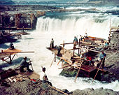
Lists - Cities
- Crossings
- Dams
- Rapids
- Tributaries
Geology and Geography - Geology of the Pacific Northwest
- Columbia River Basalt Group
- Columbia River Gorge
- Missoula Floods
- Bonneville Slide/Bridge of the Gods land bridge
- 1700 Cascadia earthquake
- 1980 eruption of Mount St. Helens
- Columbia Mountains
History - Celilo Falls
- Kettle Falls
- Dalles des Morts
- Robert Gray exploration
- Lewis and Clark Expedition
- David Thompson
- Astor Expedition
- Fort Vancouver
- Steamboats of the Columbia River
- Big Bend Gold Rush
- Steamboats of the Arrow Lakes
- Steamboats of the upper Columbia and Kootenay Rivers
- Columbia River Treaty
- Historic Columbia River Highway
- Columbia Basin Project
- Bonneville Power Administration
- Hanford Site
- Sohappy v. Smith
- Boldt Decision
- Vanport flood of 1948
Ecology and culture Categories:- Columbia River
- Irrigation projects
- Irrigation in the United States
Wikimedia Foundation. 2010.