- Clarkston, Washington
-
Clarkston, Washington — City — View of Lewiston and Clarkston from the north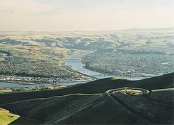 Location of Clarkston, Washington
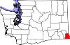
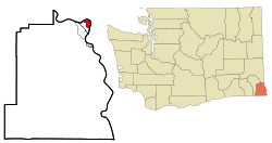
Coordinates: 46°24′49″N 117°2′55″W / 46.41361°N 117.04861°WCoordinates: 46°24′49″N 117°2′55″W / 46.41361°N 117.04861°W Country United States State Washington County Asotin Area – Total 2.0 sq mi (5.3 km2) – Land 1.9 sq mi (5.0 km2) – Water 0.1 sq mi (0.3 km2) Elevation 807 ft (246 m) Population (2010) – Total 7,229 – Density 3,805.4/sq mi (1,469.3/km2) Time zone Pacific (PST) (UTC-8) – Summer (DST) PDT (UTC-7) ZIP code 99403 Area code 509 FIPS code 53-12630[1] GNIS feature ID 1512093[2] Website http://www.clarkston-wa.com/ Clarkston is a city in Asotin County in the southeastern part of the U.S. state of Washington. It is part of the Lewiston ID-WA Metropolitan Statistical Area. The population was 7,229 in 2010.
In 1993, Walla Walla Community College opened a Branch Campus in Clarkston that serves the surrounding area, Lewiston, Idaho. It is still a major draw for the surrounding area.
With a ZIP code of 99403, Clarkston has the highest zip code of any area in the contiguous United States.
Contents
History
Clarkston was first settled in 1862 by Robert Bracken.[3] It was officially incorporated on August 14, 1902. Before becoming an official town, the area was called Jawbone Flats. The name Clarkston is a reference to William Clark, of Lewis and Clark fame. Lewiston, across the Idaho state line from Clarkston, is named for Meriwether Lewis, and is the larger and older of the two cities (ironically Lewis and Clark never even set foot on the Clarkston side of the river).
Geography
Clarkston is in the Lewis-Clark Valley, at the confluence of the Snake and Clearwater rivers.
Clarkston is located at 46°24′49″N 117°2′55″W / 46.41361°N 117.04861°W (46.413545, -117.048742).[4] Immediately across the Snake River from Clarkston is the town of Lewiston, Idaho.
According to the United States Census Bureau, the city has a total area of 2.0 square miles (5.3 km²), of which, 1.9 square miles (5.0 km²) of it is land and 0.1 square miles (0.3 km²) of it (4.93%) is water.
Demographics
As of the census[1] of 2000, there were 7,337 people, 3,120 households, and 1,790 families residing in the city. The population density was 3,805.4 people per square mile (1,467.8/km²). There were 3,414 housing units at an average density of 1,770.7 per square mile (683.0/km²). The racial makeup of the city was 94.43% White, 0.34% African American, 1.61% Native American, 0.65% Asian, 0.03% Pacific Islander, 0.79% from other races, and 2.15% from two or more races. Hispanic or Latino of any race were 2.56% of the population.
There were 3,120 households out of which 29.9% had children under the age of 18 living with them, 37.1% were married couples living together, 15.7% had a female householder with no husband present, and 42.6% were non-families. 35.7% of all households were made up of individuals and 15.6% had someone living alone who was 65 years of age or older. The average household size was 2.26 and the average family size was 2.92.
In the city the age distribution of the population shows 25.7% under the age of 18, 9.7% from 18 to 24, 26.6% from 25 to 44, 20.0% from 45 to 64, and 18.0% who were 65 years of age or older. The median age was 36 years. For every 100 females there were 86.9 males. For every 100 females age 18 and over, there were 79.3 males.
The median income for a household in the city was $25,907, and the median income for a family was $32,093. Males had a median income of $31,434 versus $20,654 for females. The per capita income for the city was $14,673. About 15.5% of families and 20.6% of the population were below the poverty line, including 27.6% of those under age 18 and 8.1% of those age 65 or over.
Port
The Port Of Clarkston is home to one of the largest cranes on a navigable waterway east of Portland. Agriculture is a major industry in the area and the port handles a lot of barge traffic carrying grains. The paper company Clearwater Paper Corporation transports wood chips and sawdust via barges for use at a Lewiston manufacturing plant. Due to its inland location on the Snake River, the port handles goods headed out to Portland-Vancouver, and inland to distributors upstream.
The port's marina has accommodations for personal boats and yachts, many of which travel through the nearby Hells Canyon.
References
- ^ a b "American FactFinder". United States Census Bureau. http://factfinder.census.gov. Retrieved 2008-01-31.
- ^ "US Board on Geographic Names". United States Geological Survey. 2007-10-25. http://geonames.usgs.gov. Retrieved 2008-01-31.
- ^ Majors, Harry M. (1975). Exploring Washington. Van Winkle Publishing Co. p. 142. ISBN 9780918664006. http://books.google.com/books?id=CoWrPQAACAAJ.
- ^ "US Gazetteer files: 2010, 2000, and 1990". United States Census Bureau. 2011-02-12. http://www.census.gov/geo/www/gazetteer/gazette.html. Retrieved 2011-04-23.
External links
Municipalities and communities of Asotin County, Washington Cities Asotin | Clarkston
CDPs Community Categories:- Populated places in Asotin County, Washington
- Cities in Washington (state)
- Lewiston metropolitan area


Wikimedia Foundation. 2010.