- Moderate-Resolution Imaging Spectroradiometer
-
"MODIS" redirects here. For the company, see MPS Group.
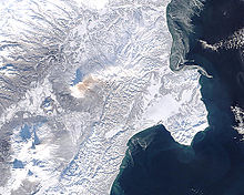
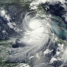 Hurricane Katrina near Florida peninsula.
 Solar irradiance spectrum and MODIS bands.
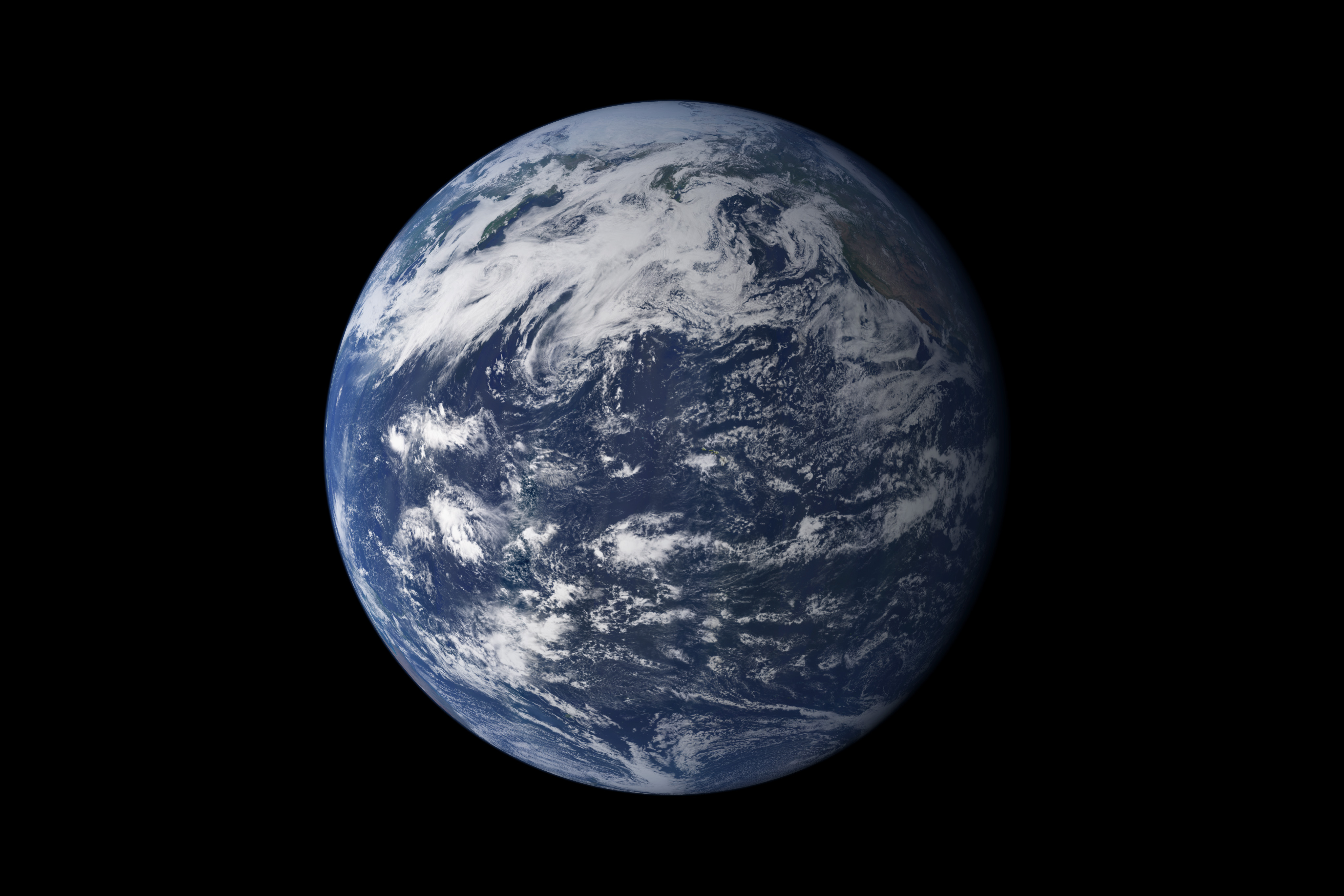
 Detailed, photo-like view of Earth is based largely on observations from MODIS.
The Moderate-resolution Imaging Spectroradiometer (MODIS) is a payload scientific instrument launched into Earth orbit by NASA in 1999 on board the Terra (EOS AM) Satellite, and in 2002 on board the Aqua (EOS PM) satellite. The instruments capture data in 36 spectral bands ranging in wavelength from 0.4 µm to 14.4 µm and at varying spatial resolutions (2 bands at 250 m, 5 bands at 500 m and 29 bands at 1 km). Together the instruments image the entire Earth every 1 to 2 days. They are designed to provide measurements in large-scale global dynamics including changes in Earth's cloud cover, radiation budget and processes occurring in the oceans, on land, and in the lower atmosphere. Three on-board calibrators (a solar diffuser combined with a solar diffuser stability monitor, a spectral radiometric calibration assembly, and a blackbody) provide in-flight calibration. MODIS has used the Marine Optical Buoy for vicarious calibration.
The MODIS Characterization Support Team (MCST) is dedicated to the production of high quality MODIS calibrated product which is a precursor to every geophysical science product. A detailed description of the MCST mission statement and other details can be found at MCST Web.
Specifications Orbit 705 km, 10:30 a.m. descending node (Terra) or 1:30 p.m. ascending node (Aqua), sun-synchronous, near-polar, circular Scan Rate 20.3 rpm, cross track Swath 2330 km (cross track) by 10 km (along track at nadir) Dimensions Telescope 17.78 cm diam. off-axis, afocal (collimated), with intermediate field stop Size 1.0 x 1.6 x 1.0 m Weight 228.7 kg Power 162.5 W (single orbit average) Data Rate 10.6 Mbit/s (peak daytime); 6.1 Mbit/s (orbital average) Quantization 12 bits Spatial Resolution 250 m (bands 1-2) 500 m (bands 3-7) 1000 m (bands 8-36) Design Life 6 years Contents
MODIS Bands
Band Wavelength
(nm)Resolution
(m)Primary Use 1 620–670 250m Land/Cloud/Aerosols
Boundaries2 841–876 250m 3 459–479 500m Land/Cloud/Aerosols
Properties4 545–565 500m 5 1230–1250 500m 6 1628–1652 500m 7 2105–2155 500m 8 405–420 1000m Ocean Color/
Phytoplankton/
Biogeochemistry9 438–448 1000m 10 483–493 1000m 11 526–536 1000m 12 546–556 1000m 13 662–672 1000m 14 673–683 1000m 15 743–753 1000m 16 862–877 1000m 17 890–920 1000m Atmospheric
Water Vapor18 931–941 1000m 19 915–965 1000m Band Wavelength
(µm)Resolution
(m)Primary Use 20 3.660–3.840 1000m Surface/Cloud
Temperature21 3.929–3.989 1000m 22 3.929–3.989 1000m 23 4.020–4.080 1000m 24 4.433–4.498 1000m Atmospheric
Temperature25 4.482–4.549 1000m 26 1.360–1.390 1000m Cirrus Clouds
Water Vapor27 6.535–6.895 1000m 28 7.175–7.475 1000m 29 8.400–8.700 1000m Cloud Properties 30 9.580–9.880 1000m Ozone 31 10.780–11.280 1000m Surface/Cloud
Temperature32 11.770–12.270 1000m 33 13.185–13.485 1000m Cloud Top
Altitude34 13.485–13.785 1000m 35 13.785–14.085 1000m 36 14.085–14.385 1000m MODIS data
MODIS Level 3 datasets
The following MODIS Level 3 (L3) datasets are available from NASA, as processed by the Collection 5 software. [1]
Daily 8-day 16-day 32-day Monthly Yearly Grid Platform Description MxD08_D3 MxD08_E3 — — MxD08_M3 — 1° CMG Terra, Aqua Aerosol, Cloud Water Vapor, Ozone MxD10A1 MxD10A2 — — — — 500 m SIN Terra, Aqua Snow Cover MxD11A1 MxD11A2 — — — — 1000 m SIN Terra, Aqua Land Surface Temperature/Emissivity MxD11B1 — — — — — 6000 m SIN Terra, Aqua Land Surface Temperature/Emissivity MxD11C1 MxD11C2 — — MxD11C3 — 0.05° CMG Terra, Aqua Land Surface Temperature/Emissivity — — MxD13C1 — MxD13C2 — 0.05° CMG Terra, Aqua Vegetation Indices MxD14A1 MxD14A2 — — — — 1000 m SIN Terra, Aqua Thermal Anomalies, Fire — — — — MCD45A1 — 500 m SIN Terra+Aqua Burned Area 250 m SIN 500 m SIN 1000 m SIN 0.05° CMG 1° CMG Time window Platform Description MxD09Q1 MxD09A1 — — — 8-day Terra, Aqua Surface Reflectance — — — MxD09CMG — Daily Terra, Aqua Surface Reflectance — MCD12Q1 MCD12Q2 MCD12C1 — Yearly Terra+Aqua Land Cover Type MxD13Q1 MxD13A1 MxD13A2 MxD13C1 — 16-day Terra, Aqua Vegetation Indices — — MxD13A3 MxD13C2 — Monthly Terra, Aqua Vegetation Indices — MCD43A1 MCD43B1 MCD43C1 — 16-day Terra+Aqua BRDF/Albedo Model Parameters — MCD43A3 MCD43B3 MCD43C3 — 16-day Terra+Aqua Albedo — MCD43A4 MCD43B4 MCD43C4 — 16-day Terra+Aqua Nadir BRDF-Adjusted Reflectance Availability
Raw MODIS data stream could be received in real-time using a tracking antenna, thanks to the instrument's direct broadcast capability.[2]
Alternatively, the scientific data is made available to the public via several World Wide Web sites and FTP archives, such as:
- ECHO Reverb — the next generation metadata and service discovery tool [3], intended to replace WIST;
- WIST — Warehouse Inventory Search Tool, scheduled for decomissioning As of 2011[update];
- LAADS Web — Level 1 and Atmosphere Archive and Distribution System (LAADS) web interface;
ftp://ladsftp.nascom.nasa.gov/— LAADS underlying FTP server;ftp://e4ftl01.cr.usgs.gov/— Earth land surface datasets;ftp://n4ftl01u.ecs.nasa.gov/— snow and ice datasets.
Most of the data is available in the HDF-EOS format — a variant of Hierarchical Data Format prescribed for the data derived from Earth Observing System missions.[4]
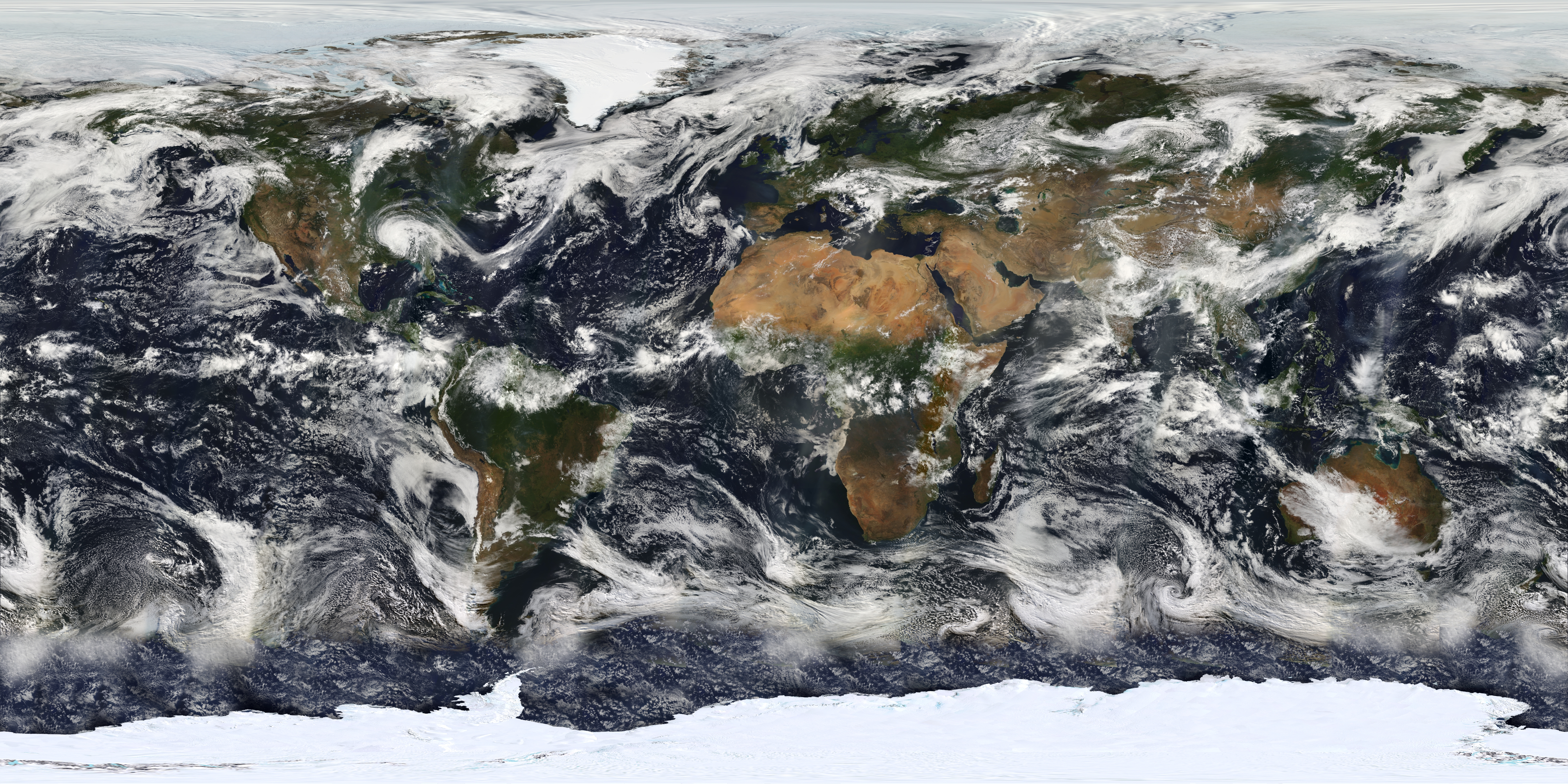
 Image based on observations from MODIS.
See also
External links
- Official NASA site
- MODIS bands and spectral ranges (broken link)
- MODIS Images of the Day
- MODIS Image of the Day - Google Gadget referring to MODIS image of the day.
- Gallery of Images of Interest
- MODIS Land Product Subsetting Tool for North America from Oak Ridge National Laboratory
- MODIS Rapid Response system (Near Real Time images)
- NASA OnEarth (Web service for MODIS imagery)
- Visible Earth: Latest MODIS images
- MODIS Sinusoidal: Projection 6842 - MODIS Sinusoidal
- Python: accessing near real-time MODIS images and fire data from NASA’s Aqua and Terra satellites (Python)
References
- ^ ""MODIS Products Table"". https://lpdaac.usgs.gov/lpdaac/products/modis_products_table. Retrieved 2011-06-12.
- ^ "Direct Broadcast at MODIS Website". http://modis.gsfc.nasa.gov/data/directbrod/. Retrieved 2009-06-02.
- ^ "About Reverb". http://www.echo.nasa.gov/reverb/about_reverb.htm. Retrieved 2011-11-07.
- ^ "HDF-EOS Tools and Information Center". http://hdfeos.net/. Retrieved 2009-06-02.
Meteorological remote sensing systems in Earth orbit Concepts Current projects A-train satellitesOther satellitesCBERS · COSMIC (FORMOSAT-3) · COSMO-SkyMed · DMSP · DMC · Elektro-L · Envisat · EROS · ERS · Fengyun · FORMOSAT-2 · GOES · IKONOS · Landsat · MetOp · Meteor · Meteosat · MTSAT · NOAA-N' · QuickBird · RADARSAT-1 · RADARSAT-2 · SMOS · SPOT · TerraSAR-X · THEOSFormer projects CompletedFailedCategories:- Spacecraft instruments
- Satellite meteorology and remote sensing
- Earth observation satellites


Wikimedia Foundation. 2010.