- Australia (continent)
-
"Sahul" redirects here. For the continental shelf, see Sahul Shelf.
Australia (continent) 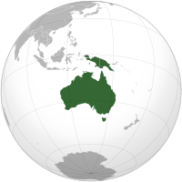
Area 8,468,300 km2 (3,269,629 sq mi) Population ~31,260,000 (estimated population of Australia, Papua New Guinea and the Papua and West Papua provinces of Indonesia for 2009) Pop. density ~ 3.7/km2 Demonym Australian Countries Australia, Papua New Guinea, East Timor, and portions of Indonesia Languages English, Indonesian, Tok Pisin, Hiri Motu, 269 indigenous Papuan and Austronesian languages and about 70 Indigenous Australian languages Time Zones GMT+10, GMT+9.30, GMT+8 Internet TLD .au, .pg and .id Largest cities List of cities in Australia by population
ListAustralia is the smallest of the world's continents, comprising the mainland of Australia and proximate islands including Tasmania, New Guinea, the Aru Islands and Raja Ampat Islands. Australia and these nearby islands, all part of the same geological landmass, are separated by seas overlying the continental shelf — the Arafura Sea and Torres Strait between Australia and New Guinea, and Bass Strait between mainland Australia and Tasmania.
When sea levels were lower during the Pleistocene ice age, including the last glacial maximum about 18,000 BC, the lands formed a single, continuous landmass. During the past ten thousand years, rising sea levels overflowed the lowlands and separated the continent into today's low-lying arid to semi-arid mainland and the two mountainous islands of New Guinea and Tasmania.
Geologically, the continent extends to the edge of the continental shelf, so the now-separate lands can still be considered a continent.[1] Due to the spread of flora and fauna across the single Pleistocene landmass the separate lands have a related biota.
New Zealand is not on the same continental shelf and so is not part of the continent of Australia but is part of the submerged continent Zealandia. Zealandia and Australia together are part of the wider region known as Oceania or Australasia. Australia is sometimes known in technical contexts by the names Sahul, Australinea and Meganesia.
Contents
Geography and nomenclature
 Mainland Australia showing the continental Sahul Shelf (light blue) extending to the islands of New Guinea in the north, the island of Timor in the northwest, and Tasmania in the south
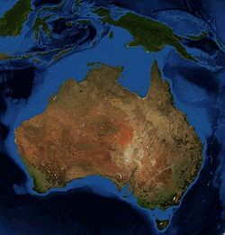
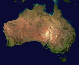 Satellite image of the country of Australia
The Australian continent is the smallest and lowest-lying human-inhabited continent on Earth, having a total land area of some 8,560,000 square kilometres (3,305,000 sq. mi.). The continental shelf connecting the islands, half of which is less than 50 metres deep covers some 2,500,000 square kilometres, including the Sahul Shelf[2][3] and Bass Strait. As the country of Australia is mostly on a single landmass, and comprises most of the continent, it is sometimes informally referred to as an "island" continent, surrounded by oceans.[4]
Prior to the 1970s, archaeologists called the single Pleistocene landmass by the name Australasia,[5] derived from the Latin australis, meaning "southern", although this word is most often used for a wider region that includes lands like New Zealand that are not on the same continental shelf.
In the early 1970s they introduced the term Greater Australia for the Pleistocene continent.[5] Then at a 1975 conference and consequent publication,[6] they extended the name Sahul from its previous use for just the Sahul Shelf to cover the continent.[5]
Biologists suggested in 1984 the name Meganesia, meaning "great island" or "great island-group", applying it to both the Pleistocene continent and the present-day lands,[7] and this name has been taken up by biologists.[8] Others have used Meganesia with different meanings: travel writer Paul Theroux included New Zealand in his definition[9] and others have used it for Australia, New Zealand and Hawaii.[10] Another biologist, Richard Dawkins coined the name Australinea in 2004.[11] Australia-New Guinea has also been used.[12]
Geology
The continent primarily sits on the Indo-Australian Plate. The lands were joined with Antarctica as part of the southern supercontinent Gondwana until the plate began to drift north about 96 million years ago (mya). For most of the time since then, Australia-New Guinea has remained a single, continuous landmass. When the last ice age ended in about 10,000 BC, rising sea levels formed Bass Strait, separating Tasmania from the mainland. Then between about 8,000 and 6,500 BC, the lowlands in the north were flooded by the sea, separating New Guinea and Australia.
Biogeography
As the continent drifted north from Antarctica, unique flora and fauna developed. Marsupials and monotremes also existed on other continents, but only in Australia-New Guinea did they out-compete the placental mammals and come to dominate. Bird life also flourished, in particular the ancestors of the great passerine order that would eventually spread to all parts of the globe and account for more than half of all living avian species.
Animal groups such as macropods, monotremes, and cassowaries are endemic to Australia. There were three main reasons for the enormous diversity that developed in both plant and animal life.
- While much of the rest of the world underwent significant cooling and thus loss of species diversity, Australia-New Guinea was drifting north at such a pace that the overall global cooling effect was roughly equalled by its gradual movement toward the equator. Temperatures in Australia-New Guinea, in other words, remained reasonably constant for a very long time, and a vast number of different plant and animal species were able to evolve to fit particular ecological niches.
- Because the continent was more isolated than any other, very few outside species arrived to colonise, and unique native forms developed unimpeded.
- Finally, despite the fact that the continent was already very old and thus relatively infertile, there are dispersed areas of high fertility. Where other continents had volcanic activity and/or massive glaciation events to turn over fresh, unleached rocks rich in minerals, the rocks and soils of Australia-New Guinea were left largely untouched except by gradual erosion and deep weathering. In general, fertile soils produce a profusion of life, and a relatively large number of species/level of biodiversity. This is because where nutrients are plentiful, competition is largely a matter of outcompeting rival species, leaving great scope for innovative co-evolution as is witnessed in tropical, fertile ecosystems. In contrast, infertile soils tend to induce competition on an abiotic basis meaning individuals all face constant environmental pressures, leaving less scope for divergent evolution, a process instrumental in creating new species.
For about 40 million years Australia-New Guinea was almost completely isolated. During this time, the continent experienced numerous changes in climate, but the overall trend was towards greater aridity. When South America eventually separated from Antarctica, the development of the cold Antarctic Circumpolar Current changed weather patterns across the world. For Australia-New Guinea, it brought a marked intensification of the drying trend. The great inland seas and lakes dried out. Much of the long-established broad-leaf deciduous forest began to give way to the distinctive hard-leaved sclerophyllous plants that characterise the modern Australian landscape.
For many species, the primary refuge was the relatively cool and well-watered Great Dividing Range. Even today, pockets of remnant vegetation remain in the cool uplands, some species not much changed from the Gondwanan forms of 60 or 90 million years ago.
Eventually, the Australia-New Guinea tectonic plate collided with the Eurasian plate to the north. The collision caused the northern part of the continent to buckle upwards, forming the high and rugged mountains of New Guinea and, by reverse (downwards) buckling, the Torres Strait that now separates the two main landmasses. The collision also pushed up the islands of Wallacea, which served as island 'stepping-stones' that allowed plants from Southeast Asia's rainforests to colonise New Guinea, and some plants from Australia-New Guinea to move into Southeast Asia. The ocean straits between the islands were narrow enough to allow plant dispersal, but served as an effective barrier to exchange of land mammals between Australia-New Guinea and Asia.
Although New Guinea is the most northerly part of the continent, and could be expected to be the most tropical in climate, the altitude of the New Guinea highlands is such that a great many animals and plants that were once common across Australia-New Guinea now survive only in the tropical highlands (where they are severely threatened by overpopulation pressures).
See also
- List of basic Australia topics
- Plate tectonics
- Paleoclimatology
- Australasia
- Oceania
References
- ^ Johnson, David Peter (2004). The Geology of Australia. Port Melbourne, Victoria: Cambridge University Press. pp. page 12.
- ^ "Big Bank Shoals of the Timor Sea: An environmental resource atlas". Australian Institute of Marine Science. 2001. http://www.aims.gov.au/pages/reflib/bigbank/pages/bb-04.html. Retrieved 2006-08-28.
- ^ Wirantaprawira, Dr Willy (2003). "Republik Indonesia". Dr Willy Wirantaprawira. http://www.wirantaprawira.net/indon/land.html. Retrieved 2006-08-28.
- ^ Löffler, Ernst; A.J. Rose, Anneliese Löffler & Denis Warner (1983). Australia:Portrait of a Continent. Richmond, Victoria: Hutchinson Group. p. 17. ISBN 0091304601.
- ^ a b c Ballard, Chris (1993). "Stimulating minds to fantasy? A critical etymology for Sahul". Sahul in review: Pleistocene archaeology in Australia, New Guinea and island Melanesia. Canberra: Australian National University. pp. 19–20. ISBN 0-7315-1540-4.
- ^ Allen, J.; J. Golson and R. Jones (eds) (1977). Sunda and Sahul: Prehistorical studies in Southeast Asia, Melanesia and Australia. London: Academic Press. ISBN 0-12-051250-5.
- ^ Filewood, W. (1984). "The Torres connection: Zoogeography of New Guinea". Vertebrate zoogeography in Australasia. Carlisle, W.A.: Hesperian Press. pp. 1124–1125. ISBN 0-85905-036-X.
- ^ e.g. Flannery, Timothy Fridtjof (1994). The future eaters: An ecological history of the Australasian lands and people. Chatswood, NSW: Reed. pp. 42, 67. ISBN 0-7301-0422-2.
- ^ Theroux, Paul (1992). The happy isles of Oceania: Paddling the Pacific. London: Penguin. ISBN 0-14-015976-2.
- ^ Wareham, Evelyn (September 2002). "From Explorers to Evangelists: Archivists, Recordkeeping, and Remembering in the Pacific Islands". Archival Science 2 (3–4): 187–207. doi:10.1007/BF02435621.
- ^ Dawkins, Richard (2004). The ancestor’s tale: A pilgrimage to the dawn of evolution. Boston: Houghton Mifflin. pp. 224. ISBN 0-618-00583-8.
- ^ e.g. O'Connell, James F.; Allen, Jim (2007). "Pre-LGM Sahul (Pleistocene Australia-New Guinea) and the Archaeology of Early Modern Humans". In Mellars, P.; Boyle, K.; Bar-Yosef, O. et al.. Rethinking the Human Revolution. Cambridge: McDonald Institute for Archaeological Research. pp. 395–410. http://www.anthro.utah.edu/PDFs/joc/32o_conn.pdf
Continents 
AustraliaHistorical continentsArctica · Asiamerica · Atlantica · Avalonia · Baltica · Cimmeria · Congo craton · Euramerica · Kalaharia · Kazakhstania · Laurentia · North China · Siberia · South China · East Antarctica · IndiaSubmerged continents
Kerguelen Plateau · ZealandiaMythical and theorized continents
Atlantis · Kumarikkandam · Lemuria · Meropis · Mu · Terra AustralisSee also Regions of the world Regions of the world 
Africa Northern · Sub-Saharan (Central · Southern · Western · Eastern) 
Oceania Australasia (Australia) · Melanesia · Micronesia · Polynesia 
America North (Northern • Middle • Central • Caribbean) · South (Southern • Northern • Western) · Anglo · Latin 
Polar Arctic · Antarctic 
Asia Central · Eastern (Northeastern) · Northern · Southeastern · Southern (Indian subcontinent) · Western (Middle East) 
Oceans World · Arctic · Atlantic · Indian · Pacific · Southern 
Europe Central · Eastern · Northern · Southeastern · Southern · Western Seas List of seas Related Continents of the world · List of seas · Physical Earth Categories:- Continents
- Australia (continent)


Wikimedia Foundation. 2010.