- South Atlantic tropical cyclone
A South Atlantic
tropical cyclone is an unusual weather event. Strongwind shear (which disrupts cyclone formation) and a lack of weather disturbances favorable for tropical cyclone development make anyhurricane -strength cyclones extremely rare. If a "hurricane season" were to be demarcated in the South Atlantic, it would most likely be the opposite of the North Atlantic season, from December to May with mid-March being the peak when the oceans are warmest in the Southern Hemisphere.Below is a list of known South Atlantic tropical cyclones.
Cyclone Catarina
Infobox Hurricane Small
Basin=SHem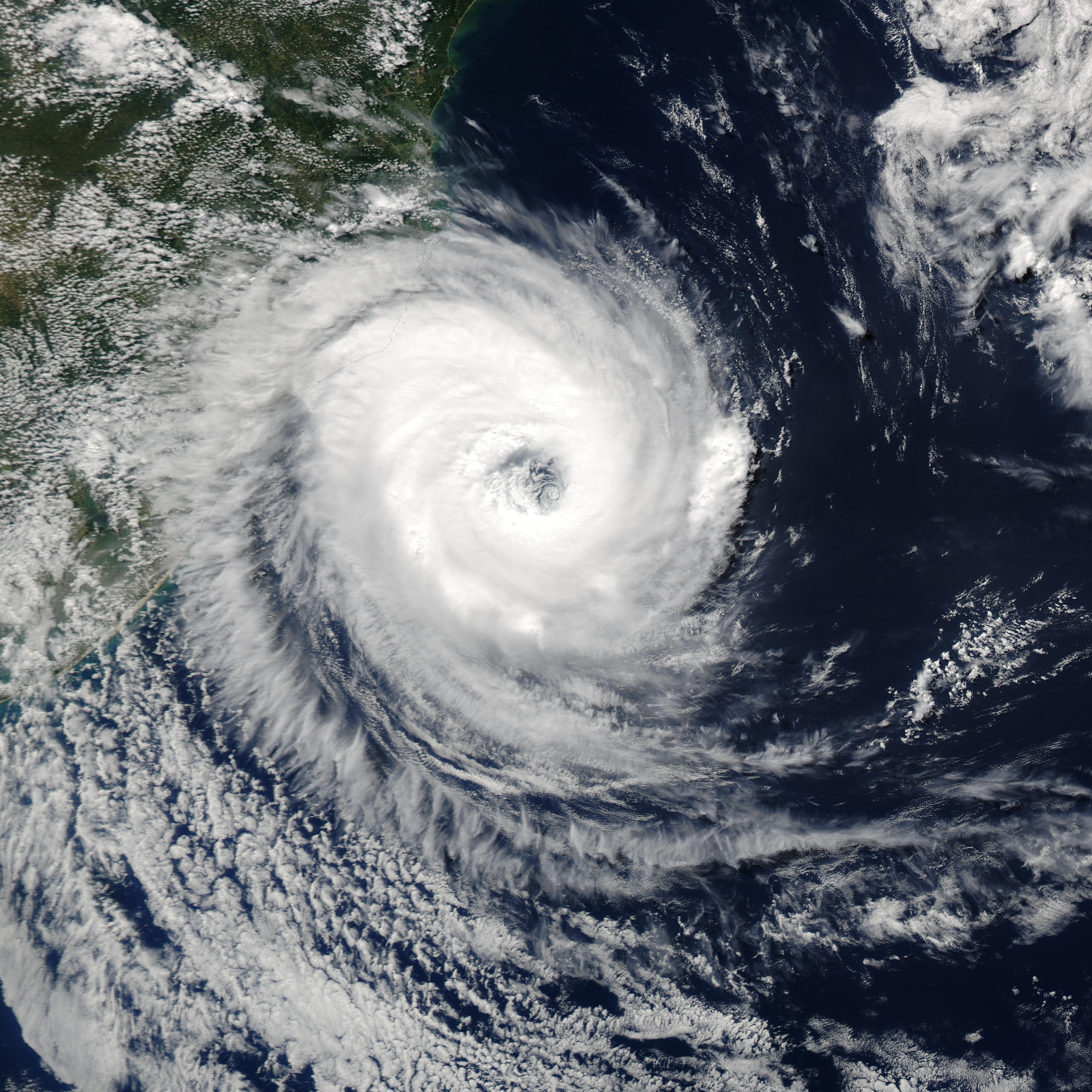
Track=Catarina 2004 track.png
Dissipated=March 28
1-min winds=85
Pressure=972Atlantic Ocean in March 2004. Just after becoming a hurricane, it hit the southern coast ofBrazil in the state of Santa Catarina on the evening of March 28, with winds estimated near 155km/h (100mph ), making it a Category 2 storm on theSaffir-Simpson Hurricane Scale . The cyclone killed 3-10 people and caused millions of dollars in damage in Brazil.This event is considered by meteorologists to be a nearly once-in-a-lifetime occurrence.
Other known South Atlantic tropical cyclones
Angola tropical cyclone of 1991
On April 10, 1991, what was either a strong tropical depression or a weak tropical stormFact|date=April 2007 formed in the eastern South Atlantic, recorded by weather satellites off the coast of
Angola . It reached a peak on the 13th, and dissipated two days later, drifting west-southwestward from where it formed. Of the few South Atlantic tropical cyclones that have existed, this was the only one in the eastern Atlantic. This was also the first South Atlantic tropical cyclone ever observed.Tropical cyclone of January 2004
A small area of convection developed on a trough of low pressure in mid January off
Brazil . It organized and appeared to become a tropical depression on January 18. The next morning, it had a small CDO and well-defined bands, and the system, either a weak tropical storm or a strong tropical depression, likely reached its peak. Located convert|150|nmi|km|-1 southeast ofSalvador, Brazil , it weakened as upper level shear, typical for the basin, prevailed. The depression moved inland on the 20th as a circulation devoid of convection, and dissipated the next day over Brazil, where it caused heavy rains and flooding. This would mark the first time in recorded history that two tropical cyclones (Catarina and the January storm) have been seen during the same year in the South Atlantic, and may be considered to make up the 2003-04 South Atlantic hurricane season. [ [http://www.australiasevereweather.com/cyclones/2004/summ0401.htm Monthly Global Tropical Cyclone Summary January 2004 ] ]Tropical cyclone of February 2006
A small area of convection 600 miles southeast of
Rio de Janeiro was tracked into an area of relatively low shear and marginal 26°C waters on February 23, 2006. The wave had deep convection, was able to form a closed LLC and had 35 mi/h (56 km/h) winds as measured by Quikscat on February 24, 2006. These characteristics were operationally recognized for three hours before high shear began to tear the system apart, just short of the six hours required to be officially declared a tropical depression. It is possible that the system maintained these features longer and may have briefly been a tropical depression. The shear would eventually cause the system to dissipate later that night. [http://www.wunderground.com/hurricane/history/satl_tc.jpgImage]See also
*
Atlantic hurricane
*Hurricane Huron
*List of notable tropical cyclones#Unusual_landfalls
*Mediterranean tropical cyclone
*Tropical cyclogenesis#Unusual_areas_of_formation References
External links
* [http://www.aoml.noaa.gov/hrd/tcfaq/G6.html NOAA info on South Atlantic Tropical Cyclones]
Wikimedia Foundation. 2010.