- Downburst
-
A downburst is created by an area of significantly rain-cooled air that, after reaching ground level, spreads out in all directions producing strong winds. Unlike winds in a tornado, winds in a downburst are directed outwards from the point where it hits land or water. Dry downbursts are associated with thunderstorms with very little rain, while wet downbursts are created by thunderstorms with high amounts of rainfall. Microbursts and macrobursts are downbursts at very small and larger scales respectively. Another variety, the heat burst, is created by vertical currents on the backside of old outflow boundaries and squall lines where rainfall is lacking. Heat bursts generate significantly higher temperatures due to the lack of rain-cooled air in their formation. Downbursts create vertical wind shear or microburst which is dangerous to aviation.
Contents
Definition
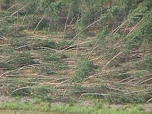
A downburst is created by a column of sinking air that, after hitting ground level, spreads out in all directions and is capable of producing damaging straight-line winds of over 150 mph (240 km/h), often producing damage similar to, but distinguishable from, that caused by tornadoes. This is because the physical properties of a downburst are completely different from those of a tornado. Downburst damage will radiate from a central point as the descending column spreads out when impacting the surface, whereas tornado damage tends towards convergent damage consistent with rotating winds. To differentiate between tornado damage and damage from a downburst, the term straight-line winds is applied to damage from microbursts.
Downbursts are particularly strong downdrafts from thunderstorms. Downbursts in air that is precipitation free or contains virga are known as dry downbursts;[1] those accompanied with precipitation are known as wet downbursts. Most downbursts are less than 2.5 miles (4 km) in extent: these are called microbursts.[2] Downbursts larger than 2.5 miles (4 km) in extent are sometimes called macrobursts.[2] Downbursts can occur over large areas. In the extreme case, a derecho can cover a huge area more than 200 miles (320 km) wide and over 1000 miles (1600 km) long, lasting up to 12 hours or more, and is associated with some of the most intense straight-line winds,[3] but the generative process is somewhat different from that of most downbursts.
Straight-line winds
Straight-line winds (also known as thundergusts and hurricanes of the prairie) are very strong winds that can produce damage, demonstrating a lack of a rotational damage pattern.[4] Such rotational damage patterns are associated with cyclonic storms including tornadoes and tropical cyclones. Straight-line winds are common with the gust front of a thunderstorm or originate with a downburst from a thunderstorm. These events can cause considerable damage, even in the absence of a tornado. The reason these storms are so dangerous is because of the consistent wind that does not let up. The winds can reach 80 m.p.h. or more and can last for periods of twenty minutes or longer. Such straight-line wind events are most common during the spring when instability is highest and weather fronts routinely cross the country. However, straight-line wind events in the form of "derechos" can take place in areas outside of the traditional tornado alley (such as in the northeastern United States/Great Lakes Region and across southern Canada).
Straight-line winds may be damaging to marine interests. Small ships, cutters and sailboats are at risk from this meteorological phenomenon.
Formation
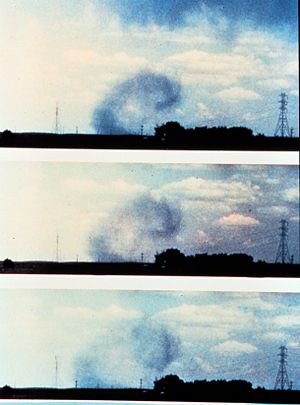
The formation of a downburst starts with hail or large raindrops falling through drier air. Hailstones melt and raindrops evaporate—this is an endothermic process that demands a lot of energy (in the form of latent heat) so the air is cooled. Cooler air has a higher density than the warmer air around it, so it falls as a "cold air balloon" (compare to a hot air balloon, which rises because hot air has a lower density than the surrounding air). As the cold air balloon hits the ground it spreads out and a mesoscale front can be observed as a gust front. Areas under and immediately adjacent to the downburst are the areas which receive the highest winds and rainfall, if any is present. Also, because the rain-cooled air is descending from the middle troposphere, a significant drop in temperatures is noticed. Due to interaction with the ground, the downburst quickly loses strength as it fans out and forms the distinctive "curl shape" that is commonly seen at the periphery of the microburst (see image). Downbursts usually last only a few minutes and then dissipate, except in the case of squall lines and derecho events. However, despite their short lifespan, microbursts are a serious hazard to aviation and property and can result in substantial damage to the area.
Heat bursts
Main article: Heat burstA special, and much rarer, kind of downburst is a heat burst, which results from precipitation-evaporated air compressionally heating as it descends from very high altitude, usually on the backside of a dying squall line or outflow boundary.[5] Heat bursts are chiefly a nocturnal occurrence, can produce winds of up to 100 mph (160 km/h), are characterized by exceptionally dry air, and can suddenly raise the surface temperature to 100 degrees Fahrenheit (38 degrees Celsius) or more, sometimes persisting for several hours.
Danger to aviation
Further information: Microburst#Danger to aircraftDownbursts, particularly microbursts, are exceedingly dangerous to aircraft which are taking off or landing due to the strong vertical wind shear caused by these events. A number of fatal crashes have been attributed to downbursts.[6]
See also
References
- ^ Fernando Caracena, Ronald L. Holle, and Charles A. Doswell III. Microbursts: A Handbook for Visual Identification. Retrieved on 9 July 2008.
- ^ a b Glossary of Meteorology. Macroburst. Retrieved on 30 July 2008.
- ^ Peter S. Parke and Norvan J. Larson. Boundary Waters Windstorm. Retrieved on 30 July 2008.
- ^ Glossary of Meteorology. Straight-line wind. Retrieved on 1 August 2008.
- ^ "Oklahoma "heat burst" sends temperatures soaring". USA Today. 1999-07-08. http://www.usatoday.com/weather/wheatbst.htm. Retrieved 2007-05-09.
- ^ NASA Langley Air Force Base. Making the Skies Safer From Windshear. Retrieved on 2006-10-22.
- National Weather Service. "Downbursts". National Weather Service Forecast Office Columbia, SC. 5 May 2010. 4 Dec. 2010. http://www.erh.noaa.gov/cae/svrwx/downburst.htm
- Fujita, T.T. (1981). "Tornadoes and Downbursts in the Context of Generalized Planetary Scales". Journal of the Atmospheric Sciences, 38 (8).
- Fujita, T.T. (1985). "The Downburst, microburst and macroburst". SMRP Research Paper 210, 122 pp.
- Wilson, James W. and Roger M. Wakimoto (2001). "The Discovery of the Downburst - TT Fujita's Contribution". Bulletin of the American Meteorological Society, 82 (1).
External links
Wikimedia Foundation. 2010.


