- South Bend, Indiana
Infobox Settlement
official_name = City of South Bend, Indiana
nicknames =
settlement_type =City 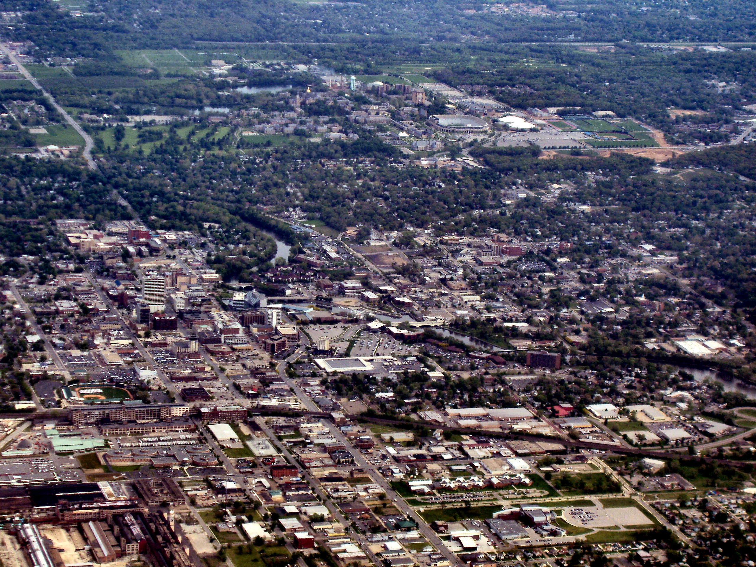
imagesize = 250px
image_caption = South Bend from above
image_

mapsize = 250x200px
map_caption = Location in the state ofIndiana
mapsize1 =
map_caption1 =
subdivision_type = Country
subdivision_name = United States
subdivision_type1 = State
subdivision_name1 =Indiana
subdivision_type2 = County
subdivision_name2 = St. Joseph
settlement_type =City
government_type = Strong Mayor-Council
leader_title =Mayor
leader_name =Steve Luecke (D)
established_title = Incorporated (City)
established_date = 1865
area_magnitude = 1 E8
area_total_km2 = 101.3
area_land_km2 = 100.2
area_water_km2 = 1.1
population_as_of = 2006
population_note =
population_total = 105494
population_density_km2 = 1075.9
timezone = EST
utc_offset = -5
timezone_DST = EDT
utc_offset_DST = -4
area_total_sq_mi = 39.1
area_land_sq_mi = 38.7
area_water_sq_mi = 0.4
elevation_m = 211
elevation_ft = 692
latd = 41 |latm = 40 |lats = 21 |latNS = N
longd = 86 |longm = 15 |longs = 19 |longEW = W
website = http://www.southbendin.gov
postal_code_type =ZIP code s
postal_code = 46600-46699
area_code = 574
blank_name = FIPS code
blank_info = 18-71000GR|2
blank1_name = GNIS feature ID
blank1_info = 0452796GR|3
footnotes =South Bend is a city on the St. Joseph river and a twin citycite book |title=The Practice of Local Government Planning |chapter=Appendix A |author=Hoch, Charles |year=2000 |publisher=American Planning Association |id=ISBN 0873260775 ] of
Mishawaka, Indiana . As of the 2000 census, the city had a total of 107,789 residents; its Metropolitan Statistical Area had a population of 316,663. It is the fourth largest city in Indiana andcounty seat of St. Joseph CountyGR|6. It is the economic and cultural hub of the region commonly known asMichiana , and may be best known as the home of theUniversity of Notre Dame .South Bend lies along the
Indiana Toll Road at the south most turn in the St. Joseph River, from which it derives its name. The area was originally settled in the early 19th century byfur trade rs, and established as a city in 1865. The St. Joseph River shaped South Bend's economy through the mid-20th century. River access led to heavy industrial development that peaked withStudebaker being based in the city, along with Oliver Chilled Plow Company and several other industrial companies.The population of South Bend has declined since its peak of 132,445 in 1960. This is in large part due to the demise of
Studebaker and other heavy industry. The 2000 census saw South Bend's population increase 2.2% from 1990, the first gain since 1960. Today, the largest industries in South Bend are health care, education, and small business. A largetourism sector also exists, mainly supported by theUniversity of Notre Dame . South Bend still remains the focal point forMichiana , with the second busiest airport in Indiana,interurban rail service to downtownChicago , and several large businesses includingCrowe Chizek , Bosch andAM General .History
The first settlements in the current South Bend area were established as fur trading posts. The first westerner to make permanent settlement was Pierre Frieschutz Navarre in 1820. Navarre arrived on behalf of the
American Fur Company . His home was not far from what would become downtown South Bend.cite book |title=South Bend: Crossroads of Commerce |chapter=At The Bend In The River |author=Palmer, John |year=2003 |publisher=Arcadia Publishing |id=ISBN 0735852414X ] Alexis Coquillard, another agent of the American Fur Company, passed through South Bend in 1823 and returned in 1824 with his family to make it his home.cite book |title=History of St. Joseph County, Indiana |chapter=Chapter XI The City of South Bend |author=Howard, Timothy E.| year=1907 |publisher=The Lewis Publishing Company ] At the time, the post was known as Big St. Joseph Station. In 1827, Lathrop Minor Taylor established a post for Samuel Hanna and Company. The area soon became known as St. Joseph's, Indiana as recorded in the Samuel Hanna and Company records. By 1829, the town was growing, with Coquillard and Taylor emerging as leaders. The town applied for a post office, and Taylor was namedpostmaster later that year. The town was designated as Southold, Allen County, Indiana . The following year, the name of the city was changed to South Bend. This change was in order to ease confusion as several other communities called Southold existed at the time. WSBT News South Bend Name Origin " [http://www.wsbt.com/goodquestion/6235201.html WSBT News Why is South Bend Called South Bend?] dead link|date=February 2008." Retrieved on2007-03-17 .] In 1831, South Bend was laid out as the county seat and as one of the four original townships of St. Joseph County. Soon after, design began on what would become the town of South Bend.The area was incorporated as a town in 1835 and rapidly grew. During the late 1830s through the 1850s, much of South Bend's development centered around the industrial complex of factories located on the two races (man-made canals along the St. Joseph River in South Bend). Several dams were created, and mills were built on each side of the river. On October 4, 1851, the first steam locomotive entered South Bend. This led to a general shift of businesses from the river toward the tracks. In 1852, Henry Studebaker set up a wagon shop in South Bend.
Studebaker would go on to become a large automobile manufacturer of the United States. Other manufacturing companies such as the Singer Sewing Company and the Oliver Chilled Plow Company would soon follow suit, and manufacturing would become the driving force in the South Bend economy through the mid-20th century.South Bend also gained from its position on what was known as "The Michigan Road", the main north–south artery of northern Indiana in the 19th century. Another significant development occurred near South Bend in 1842, when the Reverend
Edward Sorin founded theUniversity of Notre Dame , just north of the town.The University of Notre Dame Website " [http://nd.edu/aboutnd/ About Notre Dame] ." Retrieved on2007-11-13 .] Notre Dame would eventually become an intrinsic part of South Bend, contributing greatly to the economy and culture. In 1865, a petition was introduced for South Bend to incorporate as a city. South Bend held its first elections as a city on Monday, June 5, 1865.Other industries continued to develop in South Bend in the early twentieth century, including Birdsell Manufacturing Company, the
Bendix Corporation ,Honeywell ,AlliedSignal , theRobert Bosch GmbH ,South Bend Lathe Works , the O'Brien Paint Corp., and the South Bend Toy Company. Fast development led to the creation of electric rail transportation throughout the area, and in 1925 and the South Shoreinterurban streetcar service was established from downtown South Bend to downtown Chicago.Northern Indiana Commuter Transportation District " [http://www.nictd.com/links/ourhistory.htm Our History] ." Retrieved on2008-01-02 .]During World War II, the
South Bend Blue Sox All-American Girls Professional Baseball League team was formed in South Bend. The team participated in all the league's seasons from 1943-1954.All-American Girls Professional Baseball League " [http://www.aagpbl.org/league/history.cfm All-American Girls Professional Baseball League History] ." Retrieved on2006-08-30 .]By 1950, more than half of all employment was in the manufacturing sector.Indiana Business Review" [http://www.ibrc.indiana.edu/IBR/2002/outlook03/southbend.html ASouth Bend/Mishawaka - Elkhart/Goshen] ." Retrieved on
2008-01-02 .] Due to economic difficulties, theStudebaker Company closed its automotive manufacturing plants in South Bend in December 1963.Northern Indiana Center for History " [http://www.centerforhistory.org/indiana_stjoe_history.html#sb Early South Bend] ." Accessed on2006-08-30 .] A general decline in manufacturing soon followed. By the year 2000 manufacturing only made up 16% of the local economy, and the population decreased by nearly 30,000.In 1984, South Bend community leaders began seeking a minor league baseball team for the city. A stadium was constructed in 1986 and a 10 year player development contract was signed with the
Chicago White Sox . The team would be known as the South Bend White Sox. In 1994, the team's name was changed to theSouth Bend Silver Hawks .South Bend Silver Hawks " [http://www.silverhawks.com/coveleski/aboutcove/ About The Cove] ." Accessed on2006-08-30 .] The Silver Hawks are currently a Class A minor league affiliate of the Arizona Diamondbacks in the Midwest League.Geography
South Bend is located at coor dms|41|40|21|N|86|15|19|W|city (41.672597, -86.255157)GR|1. According to the
United States Census Bureau , the city has a total area of 39.1square mile s (101.3km² ), of which, 38.7 square miles (100.2 km²) is land and 0.4 square miles (1.1 km²) (1.10%) is water.South Bend is located 5 miles (8 km) from the
Michigan border, and approximately equidistant fromIllinois andOhio . The city is 93 miles (150 km) driving distance fromChicago . The nearest shore ofLake Michigan is 20 miles (32 km) away.Cityscape
The St. Joseph River flows from the east end of the city turning north near the city center, giving South Bend its name at the bend in the river. South Bend sits on the North-South continental divide, and the river flows north into Lake Michigan.WSBT" [http://www.wsbt.com/news/goodquestion/8213447.html What Does the 'North/South Continental Divide' Sign on the Bypass Mean?] ." Retrieved on
2008-01-06 ] The downtown area is located in the north central part of the city along the St. Joseph River, with Notre Dame directly adjacent to the north. The city extends further north on the west side, mainly with manufacturing and distribution facilities near theSouth Bend Regional Airport .Mishawaka is adjacent to South Bend's east side.Climate
South Bend has a
humid continental climate , with aKöppen climate classification of Dfa. Lake Michigan has a large effect on the climate of South Bend, includinglake effect snow in winter and moderating temperatures year round. June through August are the warmest months, with average temperatures above 80 °F. Normally, 42 days withthunderstorms occur each year. The snowiest month is usually January, with snow fall normally recorded from October through April.World Climate" [http://www.climate-charts.com/Locations/u/US72535001281871.html South Bend, IN, Indiana, USA: Climate and Daylight Chart] ." Retrieved on2008-01-27 .] On average South Bend receives convert|81.8|in|cm|0 of snow per year.National Weather Service Weather Forecast Office " [http://www.crh.noaa.gov/iwx/CLI/SBN/history/climatedescription.php South Bend Indiana Climate] ." Retrieved on2008-01-27 .] Spring and fall are often mild and overcast, with 293 partly cloudy to cloudy days each year.ClimateZone.com.' [http://www.climate-zone.com/climate/united-states/indiana/south-bend/ South Bend] ". Retrieved on2008-01-27 .]Infobox Weather
single_line= Y
location = South Bend
Jan_Hi_°F = 31 |Jan_REC_Hi_°F = 68
Feb_Hi_°F = 36 |Feb_REC_Hi_°F = 74
Mar_Hi_°F = 47 |Mar_REC_Hi_°F = 85
Apr_Hi_°F = 59 |Apr_REC_Hi_°F = 91
May_Hi_°F = 71 |May_REC_Hi_°F = 96
Jun_Hi_°F = 80 |Jun_REC_Hi_°F = 106
Jul_Hi_°F = 83 |Jul_REC_Hi_°F = 109
Aug_Hi_°F = 81 |Aug_REC_Hi_°F = 105
Sep_Hi_°F = 74 |Sep_REC_Hi_°F = 99
Oct_Hi_°F = 62 |Oct_REC_Hi_°F = 92
Nov_Hi_°F = 48 |Nov_REC_Hi_°F = 82
Dec_Hi_°F = 36 |Dec_REC_Hi_°F = 70
Year_Hi_°F = 59 |Year_REC_Hi_°F = 109Jan_Lo_°F = 16 |Jan_REC_Lo_°F = -22
Feb_Lo_°F = 19 |Feb_REC_Lo_°F = -20
Mar_Lo_°F = 28 |Mar_REC_Lo_°F = -13
Apr_Lo_°F = 38 |Apr_REC_Lo_°F = 11
May_Lo_°F = 48 |May_REC_Lo_°F = 24
Jun_Lo_°F = 58 |Jun_REC_Lo_°F = 35
Jul_Lo_°F = 63 |Jul_REC_Lo_°F = 42
Aug_Lo_°F = 61 |Aug_REC_Lo_°F = 40
Sep_Lo_°F = 53 |Sep_REC_Lo_°F = 29
Oct_Lo_°F = 42 |Oct_REC_Lo_°F = 12
Nov_Lo_°F = 33 |Nov_REC_Lo_°F = -7
Dec_Lo_°F = 22 |Dec_REC_Lo_°F = -18
Year_Lo_°F = 40 |Year_REC_Lo_°F = -22Jan_Precip_inch = 2.27
Feb_Precip_inch = 1.98
Mar_Precip_inch = 2.89
Apr_Precip_inch = 3.62
May_Precip_inch = 3.50
Jun_Precip_inch = 4.19
Jul_Precip_inch = 3.73
Aug_Precip_inch = 3.98
Sep_Precip_inch = 3.79
Oct_Precip_inch = 3.27
Nov_Precip_inch = 3.39
Dec_Precip_inch = 3.09
Year_Precip_inch = 3.31source = The Weather Channelcite web
url = http://www.weather.com/weather/wxclimatology/monthly/graph/USIN0624 | title = Average Weather for South Bend, IN - Temperateure and Precipitation | accessmonthday = July 29 | accessyear = 2008
publisher = | language = ]
accessdate = 2008-07-29Demographics
USCensusPop
1870= 7206
1880= 13280
1890= 21819
1900= 35999
1910= 53684
1920= 70983
1930= 104193
1940= 101268
1950= 115911
1960= 132445
1970= 125850
1980= 109727
1990= 105511
2000= 107789As of the
census GR|2 of 2000, there were 107,789 people, 42,908 households, and 25,959 families residing in the city. Thepopulation density was 2,786.4 people per square mile (1,075.9/km²). There were 46,349 housing units at an average density of 1,198.1/sq mi (462.7/km²). The racial makeup of the city was 56.05% White, 34.60% African American, 0.41% Native American, 1.20% Asian, 0.06% Pacific Islander, 4.87% from other races, and 2.80% from two or more races. Hispanic or Latino of any race were 8.45% of the population.Ancestries:
Germans (17.4%), Polish (10.6%), Irish (10.5%), English (5.8%), United States (3.9%), Hungarian (3.3%) (U.S. Census).There were 42,908 households out of which 30.5% had children under the age of 18 living with them, 39.0% were married couples living together, 17.0% had a female householder with no husband present, and 39.5% were non-families. 32.5% of all households were made up of individuals and 12.7% had someone living alone who was 65 years of age or older. The average household size was 2.45 and the average family size was 3.12.
In the city the population was spread out with 27.3% under the age of 18, 10.4% from 18 to 24, 29.3% from 25 to 44, 18.2% from 45 to 64, and 14.8% who were 65 years of age or older. The median age was 33 years. For every 100 females there were 91.1 males. For every 100 females age 18 and over, there were 86.7 males.
The median income for a household in the city was $32,439, and the median income for a family was $39,046. Males had a median income of $31,958 versus $23,744 for females. The
per capita income for the city was $17,121. About 13.6% of families and 16.7% of the population were below thepoverty line , including 24.0% of those under age 18 and 9.1% of those age 65 or over.Economy
South Bend's location on the St. Joseph River led to an industrial based economy in the late 1800s and early to mid-1900s. By the end of World War II that economy began to diminish.Historic South Bend" [http://www.monon.monon.org/sobend/main.html South Bend's Historical Heritage] ." Retrieved on
2006-08-31 .] Remnants of the old economy can still be seen in the abandoned industrial buildings around the city. Since that time, education, health care, and small business have come to the forefront of South Bend's economy.Nearby
University of Notre Dame is a large contributor to the local economy. The university is the largest employer in St. Joseph County, employing 4,758 people.Health care is another major contributor to the South Bend economy. Memorial Health Systems is the largest employer in the city.Bay Area Economics." [http://impact.nd.edu/PDF/UND_economic_impact_report_2002.pdf Notre Dame and The Local Economy:2002] ." Retrieved on
2006-08-31 .] Other notable businesses include Honeywell, Bosch,Woodwind & Brasswind and PEI Genesis. BothAM General andCrowe Chizek have corporate headquarters in South Bend.Efforts are underway to spur economic growth in South Bend. The St. Joe Valley Metronet is a not for profit organization attempting to create a more robust telecommunications infrastructure capable of inexpensive high speed data transmission. It is thought this could bring more high tech firms to the city and surrounding area.St. Joe Valley Metronet" [http://www.stjoevalleymetronet.org/ St. Joseph Valley Metronet Home] ." Retrieved on
2006-09-01 .] Redevelopment is underway for some of the abandoned industrial facilities, with the abandonedOliver Corp. buildings being the most recent example of reclaimed property.City of South Bend website." [http://www.southbendin.gov/revize/cityofsouthbend-preview/business/economic_development/oliver_industrial_park.asp South Bend Economic Development: Oliver Park] ." Retrieved on2006-08-31 .]Arts and culture
Culture
South Bend was influenced by a large influx of Polish Catholic immigrants in the late 19th century. [Swastek, Joseph. " [http://www.polishroots.org/paha/southbend_immigrants.htm PolishRoots] .". Retrieved on January 2, 2008.]
Dyngus Day is widely celebrated on the Monday afterEaster and is known locally to be the beginning of the city elections campaign season. [" [http://www.dyngusdaybuffalo.com/whatisdyngusday.html What You Need To Know About Dyngus Day] ." " [http://www.dyngusdaybuffalo.com/ dyngusdaybuffalo.com] ." Retrieved on January 2, 2008.]Fat Tuesday is also celebrated in South Bend, withPaczki s being a staple food product in the city for the day. [South Bend Prepares for Mardi Gras " [http://www.wndu.com/home/headlines/5939196.html WNDU] .". Retrieved on January 2, 2008.] There are twenty-three Catholic churches in the city and surrounding county, eleven Catholic schools, and three Catholic universities adjacent to the city inNotre Dame, Indiana . [Diocese of Fort Wayne - South Bend " [http://www.diocesefwsb.org/MAP/ Area Schools and Parishes] .". Retrieved on January 2, 2008.]The World Pulse Festival is held annually in South Bend. The event is an annual
Contemporary Christian music festival, attracting more than 50,000 visitors each year. [World Pulse Festival Attracts 50000+ "http://news.spirithit.com/index/culture_art/more/world_pulse_festival_attracts_50000/. Spirit News". Retrieved on January 2, 2008.]Museums, arts and entertainment
The
South Bend Regional Museum of Art is located in the Century Center in downtown South Bend. The Museum was opened to the public in March 1996, and features a variety of artists from South Bend and theMichiana region. Currently, over 850 works are featured in the permanent collection. The museum also offers several classes and workshops for adults and children.South Bend Regional Museum of Art. " [http://www.sbrma.org/ www.sbrma.org] ". Retrieved on2008-01-06 .]Copshaholm is one of the central features of the Northern Indiana Center for History. The 38 room mansion was built in 1895 and is currently listed in the
National Register of Historic Places . The history museum is composed of several buildings on its campus. It includes areas dedicated to the history of the St. Joseph River Valley, theUniversity of Notre Dame , theAll-American Girls Professional Baseball League , and the Kidsfirst Children's Museum.Center for History Exhibits" [http://www.centerforhistory.org/exhibits.html/ Center for History] dead link|date=February 2008." Retrieved on2006-08-30 .]The
Studebaker National Museum is a large collection of wagons and automobiles from the 150 year production history of theStudebaker company.Studebaker National Museum. " [http://www.studebakermuseum.org/campus.asp Campus Location] ". Retrieved on2008-01-06 .] The museum began as a collection of wagons and automobiles produced by Studebaker, including the Presidential carriages of Lincoln, McKinley, Harrison and Grant. The company donated the collection to the city of South Bend in 1966. The collection was housed in various locations from the Century Center to its current location in downtown South Bend adjacent to the Northern Indiana Center for History. The two museums share one campus, and together formThe Museums at Washington and Chapin .Northern Indiana Center for History<" [http://www.centerforhistory.org/CFH_SNM_museums.html] ".Retrieved on Retrieved on2008-01-06 .]South Bend is also home to the
Morris Performing Arts Center . The center was built in 1922 and included the Palace Theater, featuring vaudeville acts. The theatre saw its heyday in 1940 with the premiere ofKnute Rockne, All American starringRonald Reagan . A crowd estimated at 24,000 gathered outside the event. The theater was scheduled for demolition in 1959, when E.M. Morris purchased the facility and sold it to the city for one dollar. The Palace was then renamed the Morris Civic Auditorium. A total renovation was completed in 2000. The Morris Performing Arts Center also includes the Palais Royale Ballroom, on which restoration was recently completed. Morris Performing Arts Center. " [http://www.morriscenter.org/history.html About] ". Retrieved on2008-01-06 .] The center serves as home to the South Bend Symphony Orchestra, as well as the Broadway Theater League.Another dynamic cultural institution is the
South Bend Civic Theatre , founded in 1957. For many years it was located at The Firehouse at 701 Portage Avenue. At the beginning of 2007 a new theatre opened at 403 N. Main Street, in what was formerly the Scottish Rite Building. The new site includes a 209-seat Main Stage Auditorium and a 90-seat "black-box" Studio Theatre. South Bend Civic Theatre. " [http://www.sbct.org/history.php] ". Retrieved on2008-03-02 .] The South Bend Civic produces more than a dozen plays per year, including several productions in its Family Series.Schuyler Colfax , the 17thVice President of the United States , is interred in the city cemetery.United States Senate Art & History Home." [http://www.senate.gov/artandhistory/history/common/generic/VP_Schuyler_Colfax.htm Schuyler Colfax, 17th Vice President (1869-1873)] ".Retrieved on2008-01-06 .]ports
The University of Notre Dame's
Fighting Irish provide much of the sports action for the South Bend locale. Football Saturdays have become a major event for the city, attracting fans who come to watch the game andtailgate party . Notre Dame basketball games are also popular, along with the other sports at Notre Dame. Thanks in large part to the location of the University of Notre Dame in Notre Dame, Indiana to South Bend's immediate north, theCollege Football Hall of Fame was moved from Kings Mill,Ohio to downtown South Bend in 1995.South Bend is home to the
South Bend Silver Hawks , a class AMinor League Baseball team. The Silver Hawks play at Coveleski Stadium in downtown South Bend. In 2005 the franchise nearly moved toMarion, Illinois . A group of investors led by former Indiana Governor and South Bend MayorJoe Kernan bought the Silver Hawks, keeping the team in South Bend.Parks and recreation
The
Potawatomi Zoo opened in 1902. Potawatomi is the oldestzoo in Indiana, and features over 400 animals in its 23 acres. The zoo is run by the South Bend Parks and Recreation Department which maintains a variety of parks and facilities for the city. Pottawatomie Zoo Website " [http://potawatomizoo.org/History.asp History] ." Retrieved on2008-01-16 .] Along with the zoo, the South Bend Parks and Recreation department operates over fifty parks, golf courses, and recreational areas throughout the city. South Bend Parks and Recreation Website. " [http://sbpark.org/parks/parks.htm List of Parks] ". Retrieved on2008-01-16 ]Near the Potawatomi Zoo are the Potawatomi
Greenhouse s and Ella Morris and Muessel-Ellison Botanical Conservatories. The green houses were originally constructed in the 1920s, with the conservatories being added in the 1960s.South Bend Parks and Recreation Conservatory Website " [http://www.sbpark.org/conservatory/conservatory.html South Bend Conservatory] ." Retrieved on2008-10-23 .] In 2007 the greenhouses and conservatories were in danger of closing due to increased operating costs, but a campaign by the Botanical Society of South Bend was able to solicit funds to keep the facilities operating.South Bend Parks and Recreation Website " [http://www.sbpark.org/parks/erace.htm East Race Waterway] ." Retrieved on2008-01-16 .]The city is home to the first of the few artificial white water courses in the United States. In 1984, the abandoned East Race canal of the St. Joseph River was converted into North America's first artificial whitewater waterway.South Bend Parks and Recreation " [http://www.sbpark.org/parks/erace.htm Center for History] ." Retrieved on
2006-08-30 .] Through the use of movable barriers and obstacles the East Race provides a configurable whitewater course for recreational and competitive canoeing, kayaking and rafting.Government
South Bend government follows the
mayor-council representativemunicipal government model. The government operates out of the County-City building in downtown South Bend. The government of St. Joseph county also operates at this facility.The government of South Bend is led by the office of the
mayor . The mayor is elected to a four-year term and acts as chief executive for the city government. The current mayor is Steve Luecke. South Bend Municipal Government " [http://www.city-data.com/us-cities/The-Midwest/South-Bend-Municipal-Government.html South Bend Municipal Government] ." Retrieved on2008-10-23 .]The legislative branch of the South Bend government is the
city council . The council is composed of nine members each elected to four year terms. South Bend is divided into six districts, each district electing one council member. The final three members are electedat-large . Under Indiana state law, the council may pass resolutions andordinances . Resolutions are in regard to internal council procedures, while ordinances address city municipal codes.South Bend City Council " [http://www.southbendin.gov/city/common_council/index.asp South Bend City Council] ." Retrieved on2008-10-23 .]The final elected member of the South Bend government is the
City Clerk . The city clerk is responsible for maintaining official city records, and providing general clerical assistance to the City Council.City of South Bend - About the Clerk " [http://www.southbendin.gov/city/clerk/city_clerk.asp City of South Bend - About the Clerk] ." Retrieved on2008-10-23 .]As of 2008, Michael Dvorak is currently the St. Joseph County Prosecutor.
Education
The South Bend area is home to several institutions of higher learning; the most famous of which is the
University of Notre Dame . The university is located to the north of South Bend inNotre Dame, Indiana . The University of Notre Dame was founded by FatherEdward Sorin , a French priest, in 1842 before South Bend was incorporated as a city in 1865, and has been an intrinsic part of the South Bend area with great effect on its culture and economy. St. Mary's College and Holy Cross College are both located near Notre Dame just north of South Bend.Indiana University South Bend is the third largest campus in theIndiana University system . Enrollment in Fall 2007 was 7,517.Indiana University South Bend " [http://www.iusb.edu/~iusboir/enrl_info.shtml Enrollment Reports] ." Retrieved on2007-12-31 .] Other universities with campuses in South Bend includeBrown Mackie College ,Ivy Tech Community College of Indiana ,Purdue University and theGraduate Theological Foundation .Public schools in South Bend are operated by the
South Bend Community School Corporation . The corporation runs 17 primary centers (grades K-4), nine intermediate centers (grades 5-8), and four high schools, serving over 22,000 students as of 2006. South Bend Community School Corporation Website. [http://www.sbcsc.k12.in.us/ South Bend Community School Corporation] ]The Diocese of Fort Wayne-South Bend operates eleven private Catholic schools in South Bend. The Diocese of Forty Wayne-South Bend Website. [http://www.diocesefwsb.org/cso/schools.shtml Find a Catholic School] ]
South Bend is also home to Indiana's First Charter School, Veritas Academy.
Media
One major daily newspaper serves the South Bend Metro area, the "
South Bend Tribune ". It is distributed throughout the Michiana region and publishes five editions including a Metro edition, Mishawaka edition, Michigan edition, Penn-Harris-Madison East edition and a Marshall edition.South Bend has a wide variety of local radio broadcast available in the area. Stations' programming content contains a wide variety including
public radio ,classical music ,religious , country, andurban contemporary among others. For more information, see List of Radio Stations in South Bend, Indiana.As of 2008, the South Bend-Elkhart
designated market area is the 89th largest in the United States, with 334,370 (0.3% of the US population)homes.www.tvjobs.com. " [http://www.tvjobs.com/cgi-bin/markets/market2.cgi] ." "Nielsen Media Research ." Retrieved on July 21, 2008.] Most of the major television networks have affiliates in the Michiana area.South Bend located stations include
WNDU-TV (NBC ),WNIT-TV (PBS ) andWHME-TV (LeSEA ).Stations located in nearbyMishawaka, IN includeWSBT-TV (CBS ),WBND-LP (ABC),WCWW-LP (CW) andWMYS-LP (My Network TV ).WSJV (FOX ) also broadcasts in the Michiana area fromElkhart, IN .Infrastructure
Transportation
South Bend's location around the St. Joseph River has influenced the development of its streets. While it mainly follows a grid layout, development around the river led to roads adapted to follow the river. South Bend is connected to state and national highway systems by Indiana 2, 23, 933, US 20, 31 and by Interstate 80 and 90, the
Indiana Toll Road . Original routes of both theLincoln Highway and theDixie Highway also pass through South Bend. The Headquarters for the Lincoln Highway Association are in South Bend. [ cite web | title=Lincoln Highway Association Headquarters open in South Bend | publisher=The Indiana Chapter of the Lincoln Highway Association | url=http://www.indianalincolnhighway.com/page18.html | accessdate=2008-02-01]For transportation around the South Bend metro area, the
St. Joseph Valley Parkway was constructed between 1960 and 1990. The road connectsBenton Harbor, Michigan , South Bend, Mishawaka, and Elkhart. While segments are designated as US 20, US 31 and Indiana 331, it is simply referred to locally as "The bypass". [ cite web | title=Routes in South Bend and Metro Northern Indiana | publisher= | url=http://www.roadfan.com/sbnelkrd.html | accessdate=2007-02-10] The Indiana Toll Road/Interstate 80/90 passes through northern South Bend.Public transportation in South Bend is controlled by Transpo (South Bend Public Transportation Company). Transpo operates bus routes between South Bend and suburbs Mishawaka and Roseland Monday through Saturday. Transpo routes cover convert|183|mi|km|0 with over 60 vehicles. [ cite web | title=Transpo General Information | publisher=Transpo | url=http://www.sbtranspo.com/geninfo/gen_businfo.htm | accessdate=2008-03-14] In 2006, the Transpo fleet switched to
Bio-diesel fuel.South Bend serves as the transportation hub for
Michiana . TheSouth Bend Regional Airport lies off of US 31 and the Indiana Toll Road in the Northwest corner of South Bend. The airport connects South Bend to larger hubs includingAtlanta , Chicago O'Hare,Cincinnati ,Cleveland ,Detroit ,Indianapolis , Las Vegas,Minneapolis , Orlando, andSt. Petersburg, Florida . Over 1,000,000 passengers are served annually making it the second busiest airport in Indiana. As of 2006, land acquisition is underway for convert|200|acre|ha|0 of development. [ cite web | title=South Bend Regional Airport | publisher=Airport Hotel Guide | url=http://southbend.airporthotelguide.com/airportinfo.html | accessdate=2007-02-10]The electric commuter railroad South Shore Line connects South Bend's
South Bend Regional Airport toMillennium Station in downtownChicago . Due to increased ridership in 2005 betweenChicago and South Bend, more cars are being added. In 2008, the South Shore will be celebrating its centennial anniversary. Planning for festivities are already underway and will take place at theSouth Bend Regional Airport . [ cite news | title=South Shore Line plans centennial gala | publisher=NWI Times | url=http://nwitimes.com/articles/2006/04/10/news/porter_county/a493598350c9a4d88625714b008330f8.txt | accessdate=2007-02-10]Amtrak , the national passenger rail system, provides service to South Bend via two trains, theLake Shore Limited toChicago , New York City andBoston and the Capitol Limited, to Chicago andWashington, D.C. . A bus line connects from Notre Dame and the airport to Chicago O'Hare and Midway Airports, with several northwest Indiana stops. [ cite news | title=Amtrak Stations - South Bend | publisher=Amtrak | url=http://www.amtrak.com/servlet/ContentServer?pagename=Amtrak/am2Station/Station_Page&code=SOB | accessdate=2008-01-02]Utilities
Electricity in South Bend is provided by Indiana Michigan Power, a subsidiary of
American Electric Power . Indiana Michigan Power. " [http://www.indianamichiganpower.com/About/ About] ". Retrieved on2008-01-16 .] Natural Gas is supplied by the Northern Indiana Public Service Company (NIPSCO).NIPSCO. " [http://www.nipsco.com/aboutnipsco/index.asp About NIPSCO] ".Retrieved on2008-01-16 .]The South Bend Water Works delivers water to residents of South Bend. The water is collected from 32 deep wells and runs through 545 miles of water main to be distributed to South Bend citizens.City of South Bend." [http://www.southbendin.gov/city/departments/water_works/faq.asp Water Works FAQ] ". Retrieved on
2008-01-16 .]See also
*
List of South Bend Residents
*Northern Indiana Sister Cities
South bend has two sister cities:City of South Bend" [http://www.southbendin.gov/city/departments/comm_sp_proj/sister_cities.asp Sister Cities] ". Retrieved on
2008-01-27 .]*
Częstochowa (Poland )
* Arzberg (Germany)References
External links
* [http://www.southbendin.gov/ Official City of South Bend Website]
* [http://www.downtownsouthbend.com/ Downtown South Bend]
* [http://www.sjchamber.org/ The Chamber of Commerce of St. Joseph County]
* [http://www.livethelegends.org/ South Bend/Mishawaka Convention and Visitors Bureau]
*dmoz|Regional/North_America/United_States/Indiana/Localities/S/South_Bend
Wikimedia Foundation. 2010.