- Ocean surface topography
-
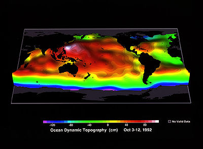
 TOPEX/Poseidon was the first space mission that allowed scientists to map ocean topography with sufficient accuracy to study the large-scale current systems of the world's ocean. Although this image was constructed from only 10 days of TOPEX/Poseidon data (October 3 to October 12, 1992), it reveals most of the current systems that have been identified by shipboard observations collected over the last 100 years.
The ocean surface has highs and lows, similar to the hills and valleys of Earth's land surface depicted on a topographic map. These variations, called "ocean surface topography" or "dynamic sea surface topography" are mapped using measurements of sea surface height relative to Earth's geoid. Earth's geoid is a calculated surface of equal gravitational potential energy and represents the shape the sea surface would be if the ocean were not in motion.
The height variations of ocean surface topography can be as much as two meters and are influenced by ocean circulation, ocean temperature, and salinity.
Ocean surface topography is used to map ocean currents, which move around the ocean's "hills" and "valleys" in predictable ways. A clockwise sense of rotation is found around "hills" in the northern hemisphere and "valleys" in the southern hemisphere. This is because of the Coriolis effect. Conversely, a counterclockwise sense of rotation is found around "valleys" in the northern hemisphere and "hills" in the southern hemisphere.[1]
Ocean surface topography is also used to understand how the ocean moves heat around the globe, a critical component of Earth's climate, and for monitoring changes in global sea level.
Ocean surface topography can be derived from ship-going measurements of temperature and salinity at depth. However, since 1992, a series of satellite altimetry missions, beginning with TOPEX/Poseidon and continued with Jason-1 and the Ocean Surface Topography Mission on the Jason-2 satellite have measured sea surface height directly. By combining these measurements with gravity measurements from NASA's Grace mission, scientists can determine sea surface topography to within a few centimeters.
A new satellite mission called the Surface Water Ocean Topography Mission has been proposed to make the first global survey of the topography of all of Earth's surface water--the ocean, lakes and rivers. This study is aimed to provide a comprehensive view of Earth’s freshwater bodies from space and more much detailed measurements of the ocean surface than ever before.[2]
See also
References
External links
Categories:- Atmospheric science stubs
- Climatology
- Oceanography
- Topography
Wikimedia Foundation. 2010.


