- Geography of Martinique
-
Martinique Nickname: Island of Flowers 
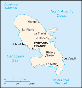
Map of Martinique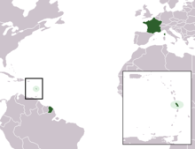
Geography Location Caribbean Sea Coordinates 14°40′N 61°00′W / 14.667°N 61°W Archipelago Windward Islands Area 1,060 km2 (409 sq mi) Coastline 350 km (217 mi) Highest elevation 1,397 m (4,583 ft) Highest point Montagne Pelee Country FranceOverseas department  Martinique
Largest city Fort-de-France (pop. 134,727) Demographics Population 429,510 (as of 2008) Density 405.2 /km2 (1,049.5 /sq mi) Ethnic groups African and African-white-Indian mixture 90%, white 5%, Indian Tamil or East Indian, Chinese less than 5% Contents
Climate
Statistics
Location: Caribbean, island in the Caribbean Sea, north of Trinidad and Tobago
Geographic coordinates: 14°40′N 61°00′W / 14.667°N 61°W
Map references: Central America and the Caribbean
Area:
total: 1,100 km²
land: 1,060 km²
water: 40 km²Area - comparative: slightly more than six times the size of Washington, D.C.
Land boundaries: 0 km
Coastline: 350 km
Maritime claims:
exclusive economic zone: 200 nmi (370.4 km; 230.2 mi)
territorial sea: 12 nmi (22.2 km; 13.8 mi)Climate: tropical; moderated by trade winds; rainy season (June to October); vulnerable to devastating cyclones (hurricanes) every eight years on average; average temperature 17.3 degrees Celsius; humid
Terrain: mountainous with indented coastline; dormant volcano
Elevation extremes:
lowest point: Caribbean Sea 0 m
highest point: Montagne Pelee 1,397 mNatural resources: coastal scenery and beaches, cultivable land
Land use:
arable land: 8%
permanent crops: 8%
permanent pastures: 17%
forests and woodland: 44%
other: 23% (1993 est.)Irrigated land: 40 km² (1993 est.)
Natural hazards: hurricanes, flooding, and volcanic activity (an average of one major natural disaster every five years)
Environment - current issues: NA
Population:429,510
See also
External links
Sovereign states Dependencies and
other territories- Anguilla
- Aruba
- Bermuda
- Bonaire
- British Virgin Islands
- Cayman Islands
- Curaçao
- Greenland
- Guadeloupe
- Martinique
- Montserrat
- Navassa Island
- Puerto Rico
- Saint Barthélemy
- Saint Martin
- Saint Pierre and Miquelon
- Saba
- Sint Eustatius
- Sint Maarten
- Turks and Caicos Islands
- United States Virgin Islands
Climate of North America Sovereign states - Antigua and Barbuda
- Bahamas
- Barbados
- Belize
- Canada
- Costa Rica
- Cuba
- Dominica
- Dominican Republic
- El Salvador
- Grenada
- Guatemala
- Haiti
- Honduras
- Jamaica
- Mexico
- Nicaragua
- Panama
- Saint Kitts and Nevis
- Saint Lucia
- Saint Vincent and the Grenadines
- Trinidad and Tobago
- United States
Dependencies and
other territories- Anguilla
- Aruba
- Bermuda
- Bonaire
- British Virgin Islands
- Cayman Islands
- Curaçao
- Greenland
- Guadeloupe
- Martinique
- Montserrat
- Puerto Rico
- Saint Barthélemy
- Saint Martin
- Saint Pierre and Miquelon
- Saba
- Sint Eustatius
- Sint Maarten
- Turks and Caicos Islands
- United States Virgin Islands
Categories:

Wikimedia Foundation. 2010.