- Geography of the Netherlands Antilles
-
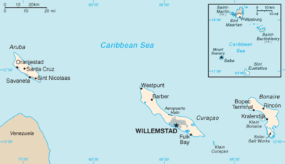
The Netherlands Antilles was a constituent country in the Caribbean Sea. It consisted of two island groups, the ABC islands Curaçao, Bonaire and (until 1986) Aruba just north of Venezuela, and the SSS islands east of the Virgin Islands.
The Netherlands Antilles had 960 km² (1153 km² before 1986) of land, which included no major lakes or other bodies of water.
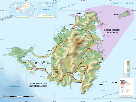
Territory included the islands of Aruba until 1986 and Curaçao, Bonaire, Saba, Sint Eustatius, Sint Maarten (which is the Dutch part of the island of Saint Martin) until 2010 when the Netherlands Antilles was dissolved. Its only land boundary was with France on the island of Saint Martin, which was 10.2 kilometers in length. The Netherlands Antilles had 364 kilometers (432 km² before 1986) of coastline.
Climate
Tropical; ameliorated by northeast trade winds
Statistics
Maritime claims:
exclusive fishing zone: 12 nmi (22.2 km; 13.8 mi)
territorial sea: 12 nmi (22.2 km; 13.8 mi)Terrain: generally hilly, volcanic interiors
Elevation extremes:
lowest point: Caribbean Sea 0 m
highest point: Mount Scenery 877 mNatural resources: phosphates (Curaçao only), salt (Bonaire only)
Land use:
arable land: 10%
permanent crops: 0%
permanent pastures: 0%
forests and woodland: 0%
other: 90% (1993 est.)Irrigated land: NA km²
Natural hazards: Curaçao and Bonaire are south of Caribbean hurricane belt and are rarely threatened; Sint Maarten, Saba, and Sint Eustatius are subject to hurricanes from July to October.
Environment - current issues: NA
Sovereign states Dependencies and
other territories- Anguilla
- Aruba
- Bermuda
- Bonaire
- British Virgin Islands
- Cayman Islands
- Curaçao
- Greenland
- Guadeloupe
- Martinique
- Montserrat
- Navassa Island
- Puerto Rico
- Saint Barthélemy
- Saint Martin
- Saint Pierre and Miquelon
- Saba
- Sint Eustatius
- Sint Maarten
- Turks and Caicos Islands
- United States Virgin Islands
Climate of North America Sovereign states - Antigua and Barbuda
- Bahamas
- Barbados
- Belize
- Canada
- Costa Rica
- Cuba
- Dominica
- Dominican Republic
- El Salvador
- Grenada
- Guatemala
- Haiti
- Honduras
- Jamaica
- Mexico
- Nicaragua
- Panama
- Saint Kitts and Nevis
- Saint Lucia
- Saint Vincent and the Grenadines
- Trinidad and Tobago
- United States
Dependencies and
other territories- Anguilla
- Aruba
- Bermuda
- Bonaire
- British Virgin Islands
- Cayman Islands
- Curaçao
- Greenland
- Guadeloupe
- Martinique
- Montserrat
- Puerto Rico
- Saint Barthélemy
- Saint Martin
- Saint Pierre and Miquelon
- Saba
- Sint Eustatius
- Sint Maarten
- Turks and Caicos Islands
- United States Virgin Islands
Sovereign states Dependencies and
other territories- Aruba
- Bonaire
- Curaçao
- Falkland Islands
- French Guiana
- South Georgia and the South Sandwich Islands
Climate of South America Sovereign states Dependencies and
other territories- Aruba
- Bonaire
- Curaçao
- Falkland Islands
- French Guiana
- South Georgia and the South Sandwich Islands
Categories:
Wikimedia Foundation. 2010.


