- Geography of Anguilla
-
This article describes the geography of Anguilla.
Anguilla 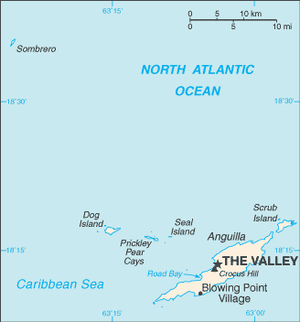
Continent North America Subregion Caribbean Geographic coordinates 18°15′N 63°10′W / 18.25°N 63.167°W Area
- Total
- WaterRanked 220th
102 km²
0 kmCoastline 61 km Land boundaries 0 km Countries bordered none Highest point Crocus Hill, 65 m Lowest point Caribbean Sea, 0 m Longest river none Largest inland body of water Land Use
- Arable land
- Permanent
crops
- Other
0 %
0 %
100 % (2005 est.)Irrigated Land: N/A Climate: tropical Terrain: flat and low-lying island of coral and limestone Natural resources salt, fish, lobster Natural hazards hurricanes, tropical storms (July to October) Environmental issues low water supplies Anguilla is one of the Leeward Islands, which lie between the Caribbean Sea in the west and the open Atlantic Ocean in the east. It is a long, flat, dry/wet, scrub-covered coral island, south and east of Puerto Rico and north of the Windward chain. It is an island of no significant elevations with its terrain consisting entirely of beaches, dunes, and low limestone bluffs.
Contents
Hills
Anguilla’s highest elevation, Crocus Hill, is 65 m (213 ft). Crocus Hill is among the cliffs that line the northern shore.
Coastline
The numerous bays — Barnes, Little, Rendezvous, Shoal, and Road—lure many vacationers to this tropical island. The coast and the beautiful, pristine beaches are integral to the tourism-based economy of Anguilla. Because of Anguilla’s warm climate, the beaches can be used year-round.
Statistics
Location: Caribbean, island in the Caribbean Sea, east of Puerto Rico
Geographic coordinates: 18 15 N, 63 10 W
Map references: Central America and the Caribbean
Area:
- total: 91 km2 (35 sq mi)
- land: 91 km2 (35 sq mi)
- water: 0 km2 (0 sq mi)
Area - comparative: about half the size of Washington DC
Land boundaries: 0 km
Coastline: 61 km
Maritime claims:
- exclusive fishing zone: 200 nmi (370.4 km; 230.2 mi)
- territorial sea: 3 nmi (5.6 km; 3.5 mi)
Climate: tropical moderated by northeast trade winds
Terrain: flat and low-lying island of coral and limestone
Elevation extremes:
- lowest point: Caribbean Sea 0 m
- highest point: Crocus Hill 65 m
Natural resources: salt, fish, lobster
Land use:
- arable land: 0%
- permanent crops: 0%
- permanent pastures: 0%
- forests and woodland: 0%
- other: 100% (mostly rock with sparse scrub oak,trees, some commercial salt ponds)
Irrigated land: NA
Natural hazards: frequent hurricanes and other tropical storms (July to October)
Environment - current issues: supplies of potable water sometimes cannot meet increasing demand largely because of poor distribution system.
Islands and cays
The territory of Anguilla consists of the island of Anguilla itself (by far the largest), as well as numerous other islands and cays, most of which are very small and uninhabited. These include:
- Anguillita
- Blowing Rock
- Cove Cay
- Crocus Cay
- Deadman's Cay
- Dog Island
- East Cay
- Little Island
- Little Scrub Island
- Mid Cay
- North Cay
- Prickly Pear Cays
- Rabbit Island
- Sandy Island, also known as Sand Island
- Scilly Cay
- Scrub Island
- Seal Island
- Sombrero, also known as Hat Island
- South Cay
- South Wager Island
- West Cay
Districts
Anguilla is divided into fourteen districts:
- Blowing Point
- East End
- George Hill
- Island Harbour
- North Hill
- North Side
- Sandy Ground
- Sandy Hill
- South Hill
- Stoney Ground
- The Farrington
- The Quarter
- The Valley
- West End
Climate
Anguilla features a tropical wet and dry climate under the Koppen climate classification. The city has a rather dry climate, moderated by northeast trade winds. Temperatures vary little throughout the year. Average daily maxima range from about 27 °C (80.6 °F) in December to 30 °C (86 °F) in July. Rainfall is erratic, averaging about 900 mm (35.4 in) per year, the wettest months being September and October, and the driest February and March. Anguilla is vulnerable to hurricanes from June to November, peak season August to mid-October. The island suffered damage in 1995 from Hurricane Luis.
Climate data for The Valley - capital of Anguilla Month Jan Feb Mar Apr May Jun Jul Aug Sep Oct Nov Dec Year Average high °C (°F) 28
(82)28
(82)28
(82)28
(82)30
(86)31
(88)31
(88)31
(88)31
(88)30
(86)29
(84)28
(82)30 Daily mean °C (°F) 26
(79)26
(79)26
(79)27
(81)27
(81)28
(82)29
(84)29
(84)29
(84)28
(82)27
(81)26
(79)27 Average low °C (°F) 23
(73)23
(73)23
(73)25
(77)25
(77)26
(79)26
(79)26
(79)26
(79)26
(79)25
(77)24
(75)23 Precipitation cm (inches) 7
(2.8)4
(1.6)4
(1.6)7
(2.8)9
(3.5)7
(2.8)8
(3.1)11
(4.3)11
(4.3)9
(3.5)11
(4.3)9
(3.5)102
(40.2)Source: Weatherbase[1] Vegetation
Anguilla’s coral and limestone terrain provide no subsistence possibilities for forests, woodland, pastures, crops, or arable lands. Its dry climate and thin soil hamper commercial agricultural development.
See also
References
- ^ "Weatherbase: Historical Weather for The Valley". http://www.weatherbase.com/weather/weatherall.php3?s=66887&refer=&units=metric.
External links
- Caribbean-On-Line.com provides detailed maps of Anguilla.
- Districts of Anguilla, Statoids.com
- Anguilla 2001 Census, Government of Anguilla
Sovereign states Antigua and Barbuda · Bahamas · Barbados · Belize · Canada · Costa Rica · Cuba · Dominica · Dominican Republic · El Salvador · Grenada · Guatemala · Haiti · Honduras · Jamaica · Mexico · Nicaragua · Panama · Saint Kitts and Nevis · Saint Lucia · Saint Vincent and the Grenadines · Trinidad and Tobago · United States
Dependencies and
other territoriesAnguilla · Aruba · Bermuda · Bonaire · British Virgin Islands · Cayman Islands · Curaçao · Greenland · Guadeloupe · Martinique · Montserrat · Navassa Island · Puerto Rico · Saint Barthélemy · Saint Martin · Saint Pierre and Miquelon · Saba · Sint Eustatius · Sint Maarten · Turks and Caicos Islands · United States Virgin Islands
Climate of North America Sovereign states Antigua and Barbuda · Bahamas · Barbados · Belize · Canada · Costa Rica · Cuba · Dominica · Dominican Republic · El Salvador · Grenada · Guatemala · Haiti · Honduras · Jamaica · Mexico · Nicaragua · Panama · Saint Kitts and Nevis · Saint Lucia · Saint Vincent and the Grenadines · Trinidad and Tobago · United States
Dependencies and
other territoriesAnguilla · Aruba · Bermuda · Bonaire · British Virgin Islands · Cayman Islands · Curaçao · Greenland · Guadeloupe · Martinique · Montserrat · Puerto Rico · Saint Barthélemy · Saint Martin · Saint Pierre and Miquelon · Saba · Sint Eustatius · Sint Maarten · Turks and Caicos Islands · United States Virgin Islands
Categories:
Wikimedia Foundation. 2010.