- Geography of Barbados
-
Barbados Nickname: Bimshire or
Little England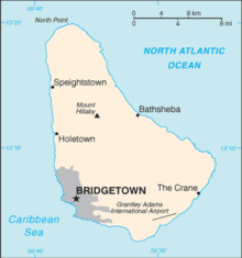
Map of Barbados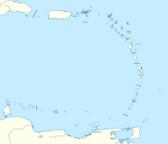
 Geography of Barbados (Lesser Antilles)
Geography Location Caribbean Sea Coordinates 13°10′N 59°32′W / 13.167°N 59.533°WCoordinates: 13°10′N 59°32′W / 13.167°N 59.533°W Area 430 km2 (166 sq mi) Length 34 km (21.1 mi) Width 24 km (14.9 mi) Coastline 97 km (60.3 mi) Highest elevation 340 m (1,120 ft) Highest point Mount Hillaby Country BarbadosLargest city Bridgetown (pop. 96,578) Demographics Population 279,000 (as of 2006) Density 648.84 /km2 (1,680.49 /sq mi) Ethnic groups 90% Afro-Caribbean,
4% European,
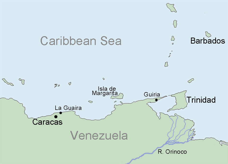
6% Asian and MultiracialBarbados is an Continental Island in the North Atlantic Ocean; and is located at 13°10' north of the equator, and 59°32' west of the Prime Meridian. As the easternmost isle of the Lesser Antilles in the West Indies, Barbados lies 100 kilometres (62 mi) east of the Windward Islands and Caribbean Sea.[1] The maritime claim for Barbados is a territorial sea of 12 nmi (22.2 km; 13.8 mi), with an exclusive economic zone of 200 nmi (370.4 km; 230.2 mi), this gives Barbados a total maritime area of 183,436 km2.[2] Of the total EEZ area 70,000 km2, is already set aside for offshore oil exploration.[3] A pending application to UNCLOS has placed for consideration a continental shelf 200 nmi (370.4 km; 230.2 mi) to the east and south (or to the edge of the continental margin). To the west, however, most of Barbados' maritime consist of a median lines with neighbours. These neighbours include: Martinique, and Saint Lucia to the northwest, Saint Vincent and the Grenadines to the west, Trinidad and Tobago and Venezuela to the southwest, and Guyana to the southeast.
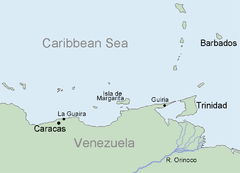 The coast of Venezuela, South America and Barbados
Barbados' total land area is 430 km2 (166.0 sq mi), and it has a coastline of 97 km (60 mi) length.[4] Sometimes compared to a pear[5] or leg of mutton for its physical shape. Along the north-south axis Barbados has a maximum length of 34 kilometres (21 mi), and east-west maximum breadth of 23 kilometres (14 mi).
The physical characteristics of Barbados are its lowlands or gently sloping, terraced plains, separated by rolling hills that generally parallel the coasts. Elevations in the interior range from 180 to 240 meters above sea level. Mount Hillaby is the highest point at 340 meters above sea level. Farther south, at Christ Church Ridge, elevations range from sixty to ninety meters. Eighty-five percent of the island's surface consists of coralline limestone twenty-four to thirty meters thick; Scotland District contains outcroppings of oceanic formations at the surface, however. Sugarcane is planted on almost 80 percent of the island's limestone surface. The soils vary in fertility; erosion is a problem, with crop loss resulting from landslides, washouts, and falling rocks. Most of the small streams are in Scotland District. The rest of the island has few surface streams; nevertheless, rainwater saturates the soil to produce underground channels such as the famous Coles Cave.
In 2009[6] and 2010, members of the upscale real estate industry in Barbados propose the creation of artificial islands to be placed off the west coast. According to Paul Altman of Altman Realty the envisioned plan, would consist of two islands, one measuring 250 acres (1.0 km2) in size, and would house new tourism based developments and upscale boutique shops; while the second island would be 50 acres (200,000 m2) in size, and would serve as an open national park. Both proposed islands would be a short distance from the Deep Water Harbour in Bridgetown.[7][8]
The south-eastern part of the island has undergone small scale oil and gas capturing from possibly as early as 1919 when the British Union Oil Company acquired over 75% of the drilling rights in Barbados.[9] Similar to Trinidad and Tobago to the southwest, the territorial Atlantic Ocean surrounding Barbados has been found to contain fossil fuels, however ongoing research is being conducted to give estimates of actual quantities.[10][11]
In 2006 a local Barbadian group has hinted that it may seek to form its own nation on Culpepper Island. At present the group is not currently recognized by any nations. It is not known how this new nation could impact on the overall eastern EEZ of Barbados.[2]Contents
DST
Barbados in the western Atlantic no longer observes Daylight Saving Time, like many Caribbean nations. The last observance of the DST related time clock adjustment was between Sunday, 20 April 1980 at 2:00 AM – Thursday, 25 September 1980 at 2:00 AM. On 25 September of that year the clock was shifted from -3:00 –> -4:00 where it has remained since.
Statistics
Location
- Barbados is Caribbean: an island between the Caribbean Sea and the North Atlantic Ocean, northeast of Venezuela
- Geographic coordinates
- 13°10′N 59°32′W / 13.167°N 59.533°W
- Map references
- Central America and the Caribbean
Area
-
- Total: 70 000 km²
- Land: 431 km²
- Water: 69 569 km²
Area comparative
-
- Australia comparative: 5.5 times smaller than the Australian Capital Territory
- Canada comparative: slightly larger than London in the Province of Ontario
- United Kingdom comparative: slightly larger than the Isle of Wight or Saint Helena
- United States comparative: 2.5 times the size of Washington, DC, about the size of San Antonio, Texas, or half the size of New York City
Land boundaries
- 0 km
- Coastline
- 97 km
- Maritime claims
-
- Exclusive economic zone: 200 nmi (370.4 km; 230.2 mi)
- Territorial sea: 12 nmi (22.2 km; 13.8 mi)
Climate
- Tropical; rainy season (June to October)
Terrain
- Relatively flat; rises gently to central highland region
- Elevation extremes
-
- Lowest point: Atlantic Ocean 0 m
- Highest point: Mount Hillaby 336 m
Natural resources
- Petroleum, fish, natural gas
Land use
-
- Arable land: 37.21%
- Permanent crops: 2.33%
- Other: 60.46% (2005)
- Irrigated land
- 50 km² (2003)
- Total renewable water sources
- 0.1 cu km (2003)
- Freshwater withdrawal (domestic/industrial/agricultural)
- total: 0.09 cu km/yr (33%/44%/22%)
- per capita: 333 cu m/yr (2000)
Natural hazards
- Infrequent hurricanes; periodic landslides
Environment - current issues
- Pollution of coastal waters from waste disposal by ships; soil erosion; illegal solid waste disposal threatens contamination of aquifers
- Environment - international agreements
-
- Party to: Biodiversity, Climate Change, Climate Change-Kyoto Protocol, Desertification, Endangered Species, Hazardous Wastes, Law of the Sea, Marine Dumping, Ozone Layer Protection, Ship Pollution, Wetlands
- Signed, but not ratified: none of the selected agreements
- Geography - note
- Easternmost Caribbean island
Climate
Barbados lies within the tropics. Its generally pleasant maritime climate is influenced by northeast trade winds, which moderate the tropical temperature. Cool, northeasterly trade winds are prevalent during the December to June dry season. The overall annual temperature ranges from 24 to 28 °C (75.2 to 82.4 °F); slightly lower temperatures prevail at higher elevations. Humidity levels are between 71 percent and 76 percent year round. Rainfall occurs primarily between July and December and varies considerably with elevation. Rainfall may average 1,875 millimeters (73.8 in) per year in the higher central area as compared with 1,275 millimeters (50.2 in) in the coastal zone.
Notes
- ^ "Windward Islands". Encyclopaedia Britannica. http://www.britannica.com/EBchecked/topic/645259/Windward-Islands. ""a line of West Indian islands constituting the southern arc of the Lesser Antilles, at the eastern end of the Caribbean Sea, between latitudes 12° and 16° N and longitudes 60° and 62° W. They include, from north to south, the English-speaking island of Dominica; the French département of Martinique; the English-speaking islands of Saint Lucia, Saint Vincent, and Grenada; and, between Saint Vincent and Grenada, the chain of small islands known as the Grenadines. Though near the general area, Trinidad and Tobago (at the south end of the group) and Barbados (just east) are usually not considered part of the Windward Islands. ""
- ^ Joseph, Cedric "Border Controversies and their Implications for Stability and Security of the Caribbean Community" UWI-CARICOM Project http://uwicaricom.org/papers-and-articles/articles/182-border-controversies-and-their-implications-for-stability-and-security-of-the-caribbean-.html?showall=1 "The Bahamas, one of six CARICOM States to claim archipelago status, with a total coastline of 11,238 km, is reported to have the largest claim to EEZ of 369,149 sq km. Barbados, with a total coastline of some 97 km and a relatively small continental shelf of 213 sq km, reportedly has a claim to some 183,436 sq km of exclusive economic zone."
- ^ Staff writer (8 August 2007) "BID Blocks carrying local names" Government of Barbados http://www.gov.bb/portal/page/portal/GISMEDIA%20CENTRENEWS%20MANAGEMENT/News%20Archive/BID%20Blocks%20carrying%20local%20names1. Retrieved 20 December 2010 "Barbados is 341(TYPO?) square kilometres in size and 70,000 sq km of its marine territorial space has been made available for the offshore hydrocarbon exploration. This means that the acreage on the market is about 162 times the size of the island’s land space."
- ^ [1]
- ^ Pariser, Harry S. (October 2000) Explore Barbados 3 Manatee Press ISBN 1893643514 http://search.barnesandnoble.com/Explore-Barbados/Harry-S-Pariser/e/9781893643512. Retrieved 2009-12-29 "Forewords & Introductions: "Just 21 mi. long by a "smile" wide, Barbados is an island of dramatic contrasts and offers many picture-postcard terrains. The island's shape has been compared to that of a ham, a leg of mutton, a pear-shaped emerald, or a lopsided pear with the stem end pointing north."
- ^ Thorne, Peter (25 February 2009). "An island north of the harbour". Caribbean Broadcasting Corporation (CBC). http://www.cbc.bb/index.pl/article?id=3392924. Retrieved 10 March 2010.[dead link]
- ^ Riley-Thornhill, Janelle (10 March 2010). "Artificial islands a viable option?". Barbados Advocate. http://www.barbadosadvocate.com/newsitem.asp?more=columnists&NewsID=9376. Retrieved 10 March 2010.
- ^ E., G. (2 March 2010). "2 man-made islands to add value to tourism product". Nation Newspaper. http://www.nationnews.com/story/LEAD-Paul-Altman-on-islands-copy-for-web. Retrieved 10 March 2010.[dead link]
- ^ BRITISH COMMERCIAL INTERESTS IN BARBADOS, HL Deb 18 April 1951 vol 171 cc376-404
- ^ B., J. (2 August 2010). "Business Monday: Boyce speaks on Barbados’ search for oil". Barbados Advocate. http://www.barbadosadvocate.com/newsitem.asp?more=business&NewsID=11778. Retrieved 2 August 2010.
- ^ 2D Long Offset Seismic
 This article incorporates public domain material from websites or documents of the Library of Congress Country Studies.
- This article incorporates public domain material from websites or documents of the CIA World Factbook.
References
- Schomburgk, Sir Robert Hermann (2001) [1848] The history of Barbados (6th ed. ed.) Frank Cass Publishers ISBN 0714619485 http://books.google.com/books?id=fUhSFjUBpVoC&lpg=PA225&ots=-Hf4ie8GyD&pg=PP1#v=onepage&q&f=false. Retrieved 12 July 2010
- Bensley, Jessica (2009) Skyviews Atlas Barbados (Ed. 1, ed.) Skyviews Caribbean ISBN 978-976-95231-0-4 http://www.atlasbarbados.com/. Retrieved 19 December 2010
- Evans, Chris (2009) "Land slides and tourist development: The slow slide of eastern Barbados into the sea" (in Eng.) Earthwise (British Geological Survey) (14.) ISSN 0967-9669 http://www.bgs.ac.uk/downloads/directDownload.cfm?id=253&noexcl=true&t=Earthwise%20Issue%2014%2C%20Geohazards
- Caves and landslips in Barbados - September 16, 2007: Barbados Advocate
- Geography & Climate of Barbados - Barbados Government
- Earthwise Issue 14, Landslides and tourist development - The slow slide of eastern Barbados into the sea, British Geological Survey
External links
- GEOnet Names Server
- BajanNAV - Free satellite navigation software for Barbados
Sovereign states Antigua and Barbuda · Bahamas · Barbados · Belize · Canada · Costa Rica · Cuba · Dominica · Dominican Republic · El Salvador · Grenada · Guatemala · Haiti · Honduras · Jamaica · Mexico · Nicaragua · Panama · Saint Kitts and Nevis · Saint Lucia · Saint Vincent and the Grenadines · Trinidad and Tobago · United States
Dependencies and
other territoriesAnguilla · Aruba · Bermuda · Bonaire · British Virgin Islands · Cayman Islands · Curaçao · Greenland · Guadeloupe · Martinique · Montserrat · Navassa Island · Puerto Rico · Saint Barthélemy · Saint Martin · Saint Pierre and Miquelon · Saba · Sint Eustatius · Sint Maarten · Turks and Caicos Islands · United States Virgin Islands
Climate of North America Sovereign states Antigua and Barbuda · Bahamas · Barbados · Belize · Canada · Costa Rica · Cuba · Dominica · Dominican Republic · El Salvador · Grenada · Guatemala · Haiti · Honduras · Jamaica · Mexico · Nicaragua · Panama · Saint Kitts and Nevis · Saint Lucia · Saint Vincent and the Grenadines · Trinidad and Tobago · United States
Dependencies and
other territoriesAnguilla · Aruba · Bermuda · Bonaire · British Virgin Islands · Cayman Islands · Curaçao · Greenland · Guadeloupe · Martinique · Montserrat · Puerto Rico · Saint Barthélemy · Saint Martin · Saint Pierre and Miquelon · Saba · Sint Eustatius · Sint Maarten · Turks and Caicos Islands · United States Virgin Islands
Template:Geography of Barbados
Categories:


Wikimedia Foundation. 2010.