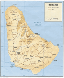
- Districts of Barbados
-
Barbados 
This article is part of the series:
Politics and government of
Barbados- Sovereign
- Elizabeth II
- The Crown
- Acting Governor-General
- Elliot Belgrave
- Prime Minister
- Freundel Stuart
- Cabinet
- The Privy Council
- Ministries
- Civil Service
- House of Assembly
- Speaker
- Michael Carrington MP
- Speaker
- Political Opposition
- Opposition Leader
- Senate
- President
- Deputy President
- Leader of the Senate
- Act of Parliament
Judiciary- Constitution
- Caribbean Court of Justice
- Supreme Court of Judicature
- Court of Appeal
- High Court
- Supreme Court of Judicature
- Magistrates Courts
- Law of Barbados
- Human rights
- Politics of Barbados
- Government
- Parliament
- Constituency Councils
- Local Government (Vestry)
- Mayor of Bridgetown
- Bridgetown City Council
- Parliament constituencies
- Political parties
- Last election
- Next election
Foreign Policy
In 1959 the country of Barbados was changed from the Vestry system, into a more modern system of local government patterned after that of the United Kingdom.[1] Two main sub-regions known as Districts were formed in Barbados, and the majority of the vestry parish councils, which acted as local government were consolidated and transferred into these larger areas and also the Bridgetown City Council.[2][3] Both were simply known as the Northern and Southern districts, and a third separate area consisted of the City of Bridgetown.[4] Each of these districts were run by Chairmen, and the city with a mayor affiliated with Barbados' political parties.[2]
Contents
Northern District
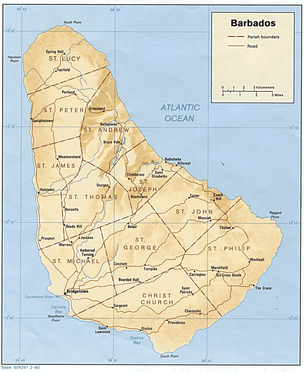
The Northern District contained all parishes northwards of the parishes of Saint Michael, Saint George and Saint John. This included:
Southern District
The Southern District contained all parishes to the south and east of Saint Michael, This included:
 Map of Barbados
City of Bridgetown
Besides the two districts, the greater Bridgetown area was devised into three city wards. These were known simply as:
- The City Ward
- The Carlisle Ward
- The Saint Michael Ward
Mayors
Mayors of Bridgetown included:
- Ernest Deighton ("E.D.") Mottley
- Louis Lynch
Local government
- The North and South districts each had their own Council. These councils were maintained by a Chairman, and was further supported by Aldermen and Councillors.[2][4]
- The City of Bridgetown as outlined in the Local Government Act, (1958); was governed by a Mayor, a Deputy Mayor, six City Aldermen(senior councillors), and twelve City Councillors (four Councillors went to each of the three wards.) [2][4]
Disestablishment
In between 1967-1969, the process of local government was phased out. At this time all local matters became transferred to the national level, to the Interim Commissioner of Local Government. The District councils and mayors were removed and constituents in each parish from then on depended on their Parliamentary representative or national government corporation, department, or statutory agencies to carry out the provision of services across Barbados' eleven parishes.[5]
Legacy
Although the districts have been abolished, the operational structure of the Royal Barbados Police Force (RBPF) still follows closely to the districting system that was once in Barbados.[6]
Within the police force:[7]
- Saint Michael is covered by District A,
- Both Christ Church and Saint George are covered by District B,
- Both Saint Philip and Saint John are covered by District C,
- Saint Thomas is covered by District D,
- Saint Peter is covered by District E,
- Saint Joseph is covered by District F.
There are additional operations located in: Holetown, Saint James; Belleplaine, Saint Andrew; and Crab Hill, Saint Lucy.
Constituency Councils
References
- ^ Parishes of Barbados, Statoids
- ^ a b c d Carrington, Sean; Fraser, Henry (2007) "Vestry" A~Z of Barbados Heritage Macmillan Caribbean - Macmillan Publishers Limited Press ISBN 0333920686
- ^ Alleyne, Warren (1978). Historic Bridgetown. Barbados: The Barbados National Trust.
- ^ a b c "The Barbados Parliament – Parliament History". Barbados Parliament website. http://www.barbadosparliament.com/history.php. Retrieved 2007-05-01.
- ^ Political and Constitutional History
- ^ "Royal Barbados Police Force - Divisions and Operations". Royal Barbados Police Force. http://www.barbadospolice.gov.bb/_sec.cfm?category=Operations. Retrieved 2009-08-05.
- ^ "POLICE CRIME DESK OPERATIONS". Barbados Government Information Service (BGIS). http://www.gisbarbados.gov.bb/index.php?categoryid=12&p2_articleid=1557. Retrieved 2009-08-05.
See also
Categories:- Subdivisions of Barbados
- History of Barbados
- Barbados-related lists
- Sovereign
Wikimedia Foundation. 2010.