- Mosquito Coast
-
This article is about the Central American area. For the film and novel, see The Mosquito Coast.
Mosquito Coast Protectorate of the United Kingdom ← 
1834–1894  →
→
 →
→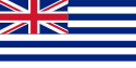
Flag
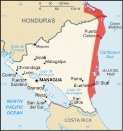
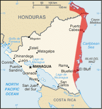
Capital Bluefields Language(s) English (official), Miskito (vernacular) Government Constitutional monarchy Monarch - 1834–1837 William IV - 1837–1894 Victoria History - Settled 1655 - Occupation 1834 - Incorporated to Nicaragua 1894 Currency British pound The Caribbean Mosquito Coast (or Miskito Coast) historically consisted of an area along the Atlantic coast of present-day Nicaragua and Honduras, and part of the Western Caribbean Zone. It was named after the local Miskito Indians and long dominated by British interests. The Mosquito Coast was incorporated into Nicaragua in 1894; however, in 1960 the northern part was granted to Honduras by the International Court of Justice.[1]
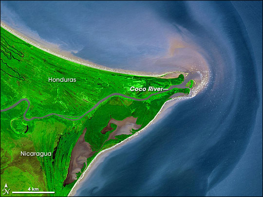
Although its name sometimes applies to the whole eastern seaboard of Nicaragua — and even to La Mosquitia in Honduras, i.e. the coast region as far west as the Río Negro or Tinto – the Mosquito Coast more accurately consisted of a narrow strip of territory, fronting the Caribbean Sea, and extending from about 11°45’ to 14°10’ N. It stretched inland for an average distance of 40 miles (64 km), and measured about 225 miles (362 km) from north to south. In the north, its boundary skirted the Wawa River; in the west, it corresponded with the eastern limit of the Nicaraguan highlands; in the south, it followed the Río Rama. The chief modern towns are Bluefields or Blewfields, the largest town and capital of Nicaragua's Región Autónoma del Atlántico Sur, Magdala on Pearl Cay, Prinzapolka on the river of that name, Wounta near the mouth of the Kukalaya, and Carata near the mouth of the coco River.
Contents
History
Before the arrival of Europeans in the region, the area was divided into a large number of small, egalitarian groups, possibly speaking languages related to Sumu and Paya. Columbus visited the coast briefly in his fourth voyage. Detailed Spanish accounts of the region, however, only relate to the late 16th and early 17th centuries. According to their understanding of the geography the region was divided between two "Provinces" Taguzgalpa and Tologalpa. Lists of "nations" left by Spanish missionaries include as many as 30 names, though careful analysis of them by Karl Offen suggests that many were duplicated and the regional geography included about a half dozen entities, speaking related by distinct dialects occupied the various river basins of the region.[2]
Attempted Spanish settlement
During the 16th century, Spanish authorities issued various licenses to conquer Taguzgalpa and Tologalpa in 1545, 1562, 1577 and 1594, but there is no evidence that any of these licenses resulted in even brief settlements or conquests. The Spanish were unable to conquer this region during the 16th century and in the 17th century sought to "reduce" the region through missionary efforts. These included several attempts by Franciscans between 1604 and 1612; another one led by Fray Cristóbal Martinez in 1622, and a third one between 1667 and 1675. None of these efforts resulted in any lasting success.[3]
Because the Spanish failed to have significant influence in the region, it was more or less independent of outside control. This allowed the indigenous people to continue as they were, and to receive visitors from other regions. As northern Europeans, particularly English and Dutch privateers entered the region, they found the Caribbean coast of Central America, particularly the Mosquito Coast, a good place to refit and rest, as well as serving for a base.
The Miskito Kingdom
Although the earliest accounts do not mention it, a political entity of uncertain organization, but probably not very stratified, which the English called the "Mosquito Kingdom" was present on the coast in the early seventeenth century. One of the kings of this polity visited England around 1638 at the behest of the Providence Island Company, and sealed an alliance with Great Britain.
In subsequent years, the kingdom stood strongly against any Spanish incursions in their region, and were prepared to offer rest and asylum to any anti-Spanish groups that might come to their shores. At the very least English and French privateers and pirates did visit there, taking in water and food. A detailed account of the kingdom written by a bucaneer known only as M. W. describes its organization as being fundamentally egalitarian, with the king, and some officials (usually called "Captains" in that period but later being more elaborate) were primarily military leaders, but only in time of war.
 Mosquito Coast, Honduras/Nicaragua
Early English alliance
The first European contacts with the Mosquito country started around 1630, when the agents of the English chartered Providence Island Company — of which the Earl of Warwick was chairman and John Pym treasurer — occupied two small cays and established friendly relations with the local inhabitants. Providence Island, the company's main base, and settlement entered into regular correspondence with the coast during the decade of company occupation, 1631-41.[4]
The Providence Island Company sponsored the Miskito's "King's Son" to visit England, during the reign of Charles I (1625–49). When his father died, this son returned home and placed his country under English protection.[5] Following the capture of Providence Island by Spain in 1641, England did not possess a base close to the coast. However, shortly after the English captured Jamaica in 1655, they recommenced relations with the coast, and Oldman went to visit England. According to the testimony of his son Jeremy, taken around 1699 was received in audience by "his brother king," Charles II and was given a "lac'd hat" and a commission "to kindly use and relieve such straggling Englishment as should chance to come that way." [6]
The Emergence of the Mosquitos Zambos (Miskito Sambu)
Main article: Miskito SambuWhile accounts vary, the Miskito Sambu originated from the survivors of a shipwrecked slave ship who arrived in the mid-seventeenth century. These survivors intermarried with the local Miskito people and produced mixed-race offspring. They also adopted the language and much of the culture of their hosts. The Miskito Sambu settled in the valley of the Wanks River, and by the late seventeenth century held the office of General with jurisdiction over the northern portions of the Miskito Kingdom. In the early eighteenth century, they managed to take over the office of King, which they held for at least the rest of the century.
In the late 17th and early 18th centuries, Miskitos Zambos began a series of raids that attacked Spanish held territories and still independent indigenous groups in the area. Miskito raiders reached as far north as the Yucatán, and as far south as Costa Rica. Many of the people they captured were sold as slaves to English merchants and carried to Jamaica.[7] This raiding gradually put the Zambos in the more dominant position and the king's domain was inhabited primarily by Zambos. They also assisted government of Jamaica in hunting down Maroons in the 1720s.[8]
Sociopolitical system
Although English accounts call the area a "kingdom'" it was loosely organized. A description of the kingdom written in 1699 shows that it was discontinuously spread out along the coast and probably did not include a number of settlements of English traders.[9] Although English accounts refer to the ruler as a "king" and subsequently to other noble titles, Miskito social structure does not appear to have been particularly stratified. The 1699 description noted that people holding titles such as "king" and "governor" were only empowered as war leaders, and did not have the last word in judicial disputes either. Otherwise, the author saw the population as living in an egalitarian state.[10]
M. W. mentioned titled officers in his account of 1699, but later sources define these superior offices to include the king, a Governor, and a General. In the early 18th century, the Miskitu kingdom became organized into four distinct clusters of population, centered on the banks of the navigable rivers, but integrated into a single, if loosely structured political entity. The northern portions were dominated by Sambus and the southern ones by Tawira Miskitos.[11] The King, whose domain lay from the Wanks River south to the Rio Kukakalaya, including the king's residence near Sandy Bay. was a Sambu, as was the General, who ruled the northern portions of the kingdom, from the Wanks River to nearly Trujillo. The Governor, who was a Tawira, controlled the southern regions, from the Cucalaya River to Pearl Key Lagoon. In the later 18th century, (post 1766) yet another title, Admiral appeared, also a Tawira, controlling a region on the extreme south from Pearl Key Lagoon down to around Bluefields.[12]
Spain, Great Britain and the Miskito Kingdom
The Miskito king and the British concluded a formal Treaty of Friendship and Alliance in 1740 and John Hodgson was appointed as Superintendent of the Shore.[13] A protectorate was established over the Miskito Nation, often called the Mosquito Coast.
Spain, which claimed the territory, objected to their presence, but did not act against them for many years. Finally, during the American Revolutionary War, Spanish forces attempted to eliminate the British presence, seizing the settlement at Black River, and driving British settlers from the isle of Roatán, however this ultimately failed when the Anglo Irish soldier Edward Despard with armed settlers retook the settlements.
Following the 1786 Convention of London, Britain evacuated settlers and their slaves from the Mosquito Coast to their colony in Belize, but continued to claim a protectorate over the Miskitos. Spain attempted to establish additional colonial outposts in the area, without much success. As Spain's former colonies in Central America gained their independence in 1821 and then began a series of wars to determine whether there would be a federalist, unitary union, or each former province would be independent, the potential of any regional power to threaten the Miskito kingdom declined. At the same time, the mahogany trade peaked in Europe, and Belize, a principal supplier of wood had deforested the easier stands of the wood. So the Miskito Kingdom, where there were still mahogany trees, became of interest to Britain which began to encourage British settlement there in 1837.[14]
British influence persisted until 1860, and was disputed by Central American nations and by the United States operating under the Monroe Doctrine. The opposition of the United States was due in large part to the fear that Britain would acquire a privileged position in regard to a proposed inter-oceanic canal. In 1848, the seizure of San Juan del Norte, subsequently renamed Greytown by the Miskito supported by a British warship, aroused great excitement in the United States, and even involved the risk of war. In 1854, the American ship USS Cyane bombarded Greytown after failing to receive compensation for violence which had been directed against Solon Borland, an American diplomat, and other US citizens. But through the Clayton-Bulwer Treaty of 1850, both powers pledged themselves not to fortify, colonise or exercise dominion over any part of Central America; in November 1859, Britain delegated its protectorate to Honduras.
This caused great dissatisfaction among the Miskito, who shortly afterwards revolted; and on 28 January 1860 Britain and Nicaragua concluded the treaty of Managua, which transferred to Nicaragua the suzerainty over the entire Caribbean coast from Cabo Gracias a Dios to Greytown but granted autonomy to the Miskito in the more limited Mosquito Reserve (the area described above). King George Augustus Fredric II accepted this change on condition that he should retain his local authority, and receive a yearly subvention of £1000 until 1870. On his death in 1865, Nicaragua refused to recognize his successor, William Henry Clarence.
The reserve nevertheless continued to be governed by an elected chief, aided by an administrative council, which met in Bluefields; and the Miskito denied that the suzerainty of Nicaragua connoted any right of interference with their internal affairs. The question was referred for arbitration to the Habsburg emperor of Austria, whose award (published in 1880) upheld the contention of the Indians, and affirmed that the suzerainty of Nicaragua was limited by the Miskitos' right of self-government.
Annexation to Nicaragua
When in 1894 Rigoberto Cabezas led a campaign to annex the reserve, natives responded with vigorous protest, an appeal to Britain to protect them, and more militant resistance [15] — to little avail. The situation was such that, from July 6 to August 7, the US occupied Bluefields to 'protect US interests'. After enjoying almost complete autonomy for fourteen years, on 20 November 1894 their territory formally became incorporated in that of the republic of Nicaragua by Nicaraguan president José Santos Zelaya. The former Mosquito Coast was established as the Nicaraguan department of Zelaya. During the 1980s, the department disappeared, substituted by RAAN (Región Autónoma del Atlántico Norte) and RAAS (región Autónoma del Atlántico Sur), autonomous regions with a certain degree of self-government.
The first version of the Mosquito Coast flag was adopted 1834. The second was adopted in 1860 when the Nicaraguan flag replaced the Union Flag in the canton.
In 1847 Moravian Church missionaries from Herrnhut, Kingdom of Saxony in what is today Germany, began mission work among the Miskito Indians and Creoles. By the end of the century, almost the entire native population had been converted.[citation needed]
Miskito Under Nicaragua
The Miskito continued to enjoy a certain autonomy under Nicaragua, and there was considerable tension between the claims of the government and that of the indigenous people. This tension was expressed quite openly during the Sandanista rule, which sought greater state control, and the Miskito were strong supporters of U. S. efforts to undermine the Sandanistas, as important supports of the Contras.
More recently dissident Miskito have created the Communitarian Nation of Moskitia.
Miskito Kings
- c 1650–c 1687 Oldman
- c 1687–1718 Jeremy I
- 1718–1729 H.M. Jeremy II
- 1729–1739 H.M. Peter I
- 1739–1755 H.M. Edward I
- 1755–1776 H.M. George I
- 1776–1801 H.M. George II Frederic
- 1801–1824 H.M. George Frederic Augustus I
- 1824–1842 H.M. Robert Charles Frederic
- 1842–1865 H.M. George Augustus Frederic II
- 1865–1879 H.E. William Henry Clarence, Hereditary Chief of Miskito
- 1879–1888 H.E. George William Albert Hendy, Hereditary Chief of Miskito
- 1888–1889 H.E. Andrew Hendy, Hereditary Chief of Miskito
- 1889–1890 H.E. Jonathan Charles Frederick, Hereditary Chief of Miskito
- 1890–1908 H.E. Robert Henry Clarence, Hereditary Chief of Miskito
Inhabitants
The Mosquito Coast of Nicaragua has a population of 118,000 inhabitants, consisting of 57% Miskito, 22% Creoles (Afro-Europeans) 15% Ladinos, 4% Sumu (Amerindian), 1% Garifuna (Afro-Indians), 0.5% Chinese and 0.5% Rama (Amerindian).[16]
Miskito Creole Ladino Sumo Garifuna Chinese Rama 57% 22% 15% 4% 1% .5% .5% See also
- Garifuna people
- Miskito
- La Mosquitia
- Nicaragua
Footnotes
- ^ "Mosquito Coast". Encyclopædia Britannica (Britannica Concise Encyclopedia). http://concise.britannica.com/ebc/article-9372678/Mosquito-Coast. Retrieved 2007-08-03.
- ^ Offen, Karl (2002). "The Sambo and Tawira Miskitu: The Colonial Origins and Geography of Intra-Miskitu Differentiation in Eastern Nicaragua and Honduras". Ethnohistory 49 (2): 319–372 [pp. 328–333]. doi:10.1215/00141801-49-2-319.
- ^ Añoveros, Jesus Maria Garcia (1988). "La presencia franciscana en la Taguzgalpa y la Tologalpa (La Mosquitia)". Mesoamérica 9: 58–63.
- ^ Karen Oldal Kupperman, Providence Island: The Other Puritan Colony, 1631-41 (Cambridge, 19xx), pp.
- ^ Hans Sloane, A Voyage to the Islands of Madera, Barbados, Nieves, St. Christophers and Jamaica... (2 vols., London, 1707), pp. lxxvi-lxxvii, according to a conversation held with Jeremy, the future king in about 1688
- ^ M. W. "The Mosqueto Indian and his Golden River," in Ansham Churchill, A Collection of Voyages and Travels (London, 1732), vol. 6, p.288.
- ^ Helms, Mary (1983). "Miskito Slaving and Culture Contact: Ethnicity and Opportunity in an Expanding Population". Journal of Anthropological Research 39 (2): 179–197. JSTOR 3629966.
- ^ German Romero Vargas, Las sociedades del Atlántico de Nicaragua en los siglos XVII y XVIII (Managua, 1995), p.165.
- ^ W. M. "The Mosqueto Indian and His Golden River," in Anshaw Churchill, A Collection of Voyages and Travels (6 vols., London, 1728) vol. 6 pp. 285-290.
- ^ M. W. "Mosketo Indian" p. 293.
- ^ Offen, Karl (2002). "The Sambo and Tawira Miskitu: The Colonial Origins and Geography of Intra-Miskitu Differentiation in Eastern Nicaragua and Honduras". Ethnohistory 49 (2): 319–372. doi:10.1215/00141801-49-2-319.
- ^ Olien, Michael (1998). "General, Governor and Admiral: Three Miskito Lines of Succession". Ethnohistory 45 (2): 278–318. JSTOR 483061.
- ^ Troy Floyd, The Anglo-Spanish Struggle for Mosquitia (Albuquerque, NM, 1967), pp. 68-69. The treaty itself, for in National Archives (UK) CO 123/3, fols 185-188 is undated and could be 1739.
- ^ Naylor, Robert A. (1967). "The Mahogany Trade as a Factor in the British Return to the Mosquito Shore in the Second Quarter of the Nineteenth Century". Jamaica Historical Journal 7: 63–64.
- ^ Charles Hale, 1994, p.37
- ^ Lenguas indigenas
Sources and references
- http://www.flag.de/FOTW/flags/ni-mc.html - Mosquito Coast flag
- RoyalArk-Mosquitos
- A Bibliography of the Mosquito Coast of Nicaragua by Courtney de Kalb, in Bulletin of the American Geographic Society., vol. xxvi. (1894)
- Studies of the Mosquito Shore in 1892 by the same author, and in the same publication, vol. xxv. (I893)
- A Forgotten Puritan Colony in No. 165 of Blackwood's Magazine (Edinburgh, 1898), described the attempt at colonization made in 1630.
- See also Der Streit um die Mosquito-Küste by J. Richter, in Zeitschrift f. Gesellschaft d. Erdkunde, No. 30 (Berlin, 1895).
- Mitla: A Narrative of Incidents and Personal Adventures on a Journey in Mexico, Guatemala and Salvador in the years 1853 to 1855 by G. F. Von Tempsky (London, 1858)
- Von Tempsky: Adventurer by W. T. Parham (Hodder & Stoughton, London, 1969) SBN 340 10798 7 (Chapters 2 & 6 are on the Mosquito Coast)
- The War in Nicaragua by W. Walker (New York, 1860)
- Charles Hale, 'Resistance and Contradiction: Miskitu Indians and the Nicaraguan State, 1894-1987'. Stanford University, 1994. 304 pgs.
 This article incorporates text from a publication now in the public domain: Chisholm, Hugh, ed (1911). Encyclopædia Britannica (11th ed.). Cambridge University Press.
Coordinates: 13°22′44″N 83°35′02″W / 13.379°N 83.584°W
Monarchies in the Americas Current Indigenous monarchiesSettled monarchiesFormer Indigenous monarchiesAraucania and Patagonia · Aztec · Brazil · Haiti (1804-1806) · Haiti (1811-1820) · Haiti (1849-1859) · Inca · Maya · Mexico (1822-1823) · Mexico (1864-1867) · Miskito · TaínoColonial monarchiesRelated List of monarchs in the Americas · List of the last monarchs in the AmericasCategories:- Former monarchies of North America
- Former countries in North America
- Former British protectorates
- States and territories established in 1834
- States and territories disestablished in 1894
- Miskito
- Geography of Nicaragua
- Former English colonies
- Regions of Central America

Wikimedia Foundation. 2010.