- Geography of Guam
-
Guam Native name: Guåhån 
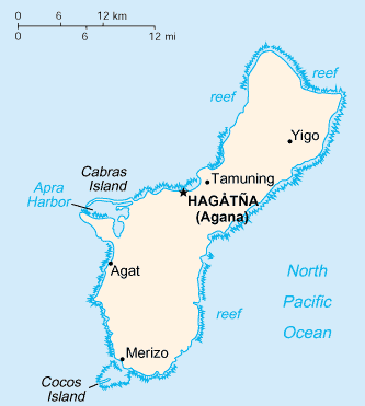
Map of Guam (See detailed map)
Geography Location Pacific Ocean Coordinates 13°26′31″N 144°46′35″E / 13.44194°N 144.77639°ECoordinates: 13°26′31″N 144°46′35″E / 13.44194°N 144.77639°E Archipelago Mariana Islands Area 541.3 km2 (209 sq mi) Length 51 km (31.7 mi) Width 15 km (9.3 mi) Highest elevation 406 m (1,332 ft) Highest point Mount Lamlam Country United StatesTerritory of the United States  Guam
GuamLargest city Dededo (pop. 46,000) Demographics Population 173,456 (as of 2007) Density 320.44 /km2 (829.94 /sq mi) Ethnic groups Native Chamorros (57%), Filipino (25.5%), White (10%), Chinese, Japanese and Korean ancestry Pass of the ISS over Mongolia, looking out west towards the Pacific Ocean, China, and Japan. As the video progresses, you can see major cities along the coast and the Japanese islands on the Philippine Sea. The island of Guam can be seen further down the pass into the Philippine Sea, and the pass ends just to the east of New Zealand. A lightning storm can be seen as light pulses near the end of the video.
This article describes the geography of Guam.
- Location
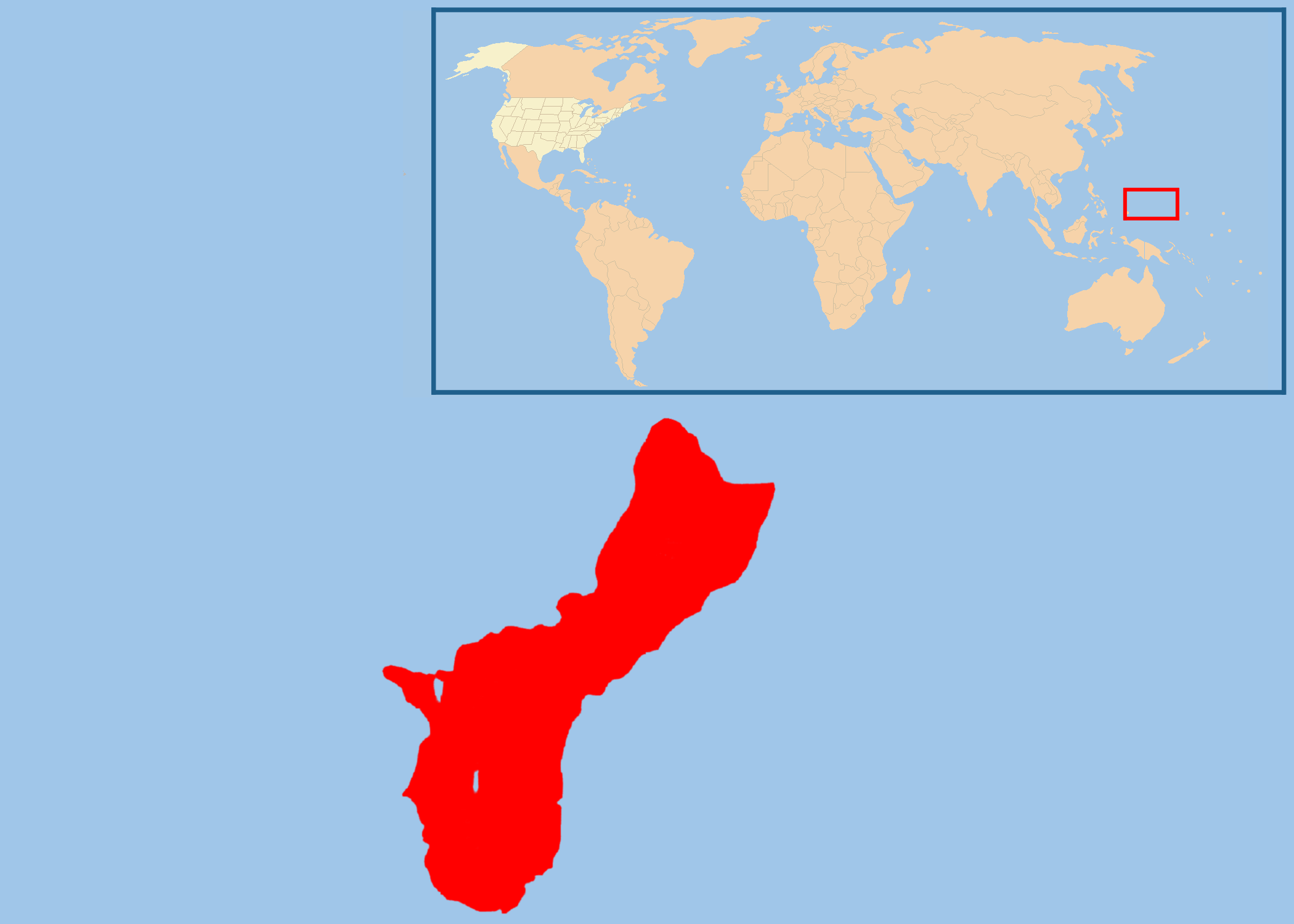
- Oceania, island in the North Pacific Ocean, about a quarter of the way from the Philippines to Hawaii, U.S.A.
- Geographic coordinates
- 13°26′31″N 144°46′35″E / 13.44194°N 144.77639°E
- Map references
- Oceania
- Area
-
- Total: 541.3 km²
- Land: 541.3 km²
- Water: 0 km²
- Area (comparative)
- Three times the size of Washington, D.C.
- Land boundaries
- Approximately 30 miles (51 km) long and 9 miles (15 km) wide, narrowing to 4 miles (7 km) at the center.
- Coastline
- 125.5 km (78.0 mi)
- Maritime claims
-
- Exclusive economic zone: 200 nm (370.4 km)
- Territorial sea: 12 nm (22.224 km)
- The southern maritime boundary of Guam forms a border with the Federated States of Micronesia, and the northern maritime boundary forms a border with the Commonwealth of the Northern Marianas Islands.
- Climate
- Tropical marine; generally warm and humid, moderated by northeast trade winds; dry season from January to June, wet season from July to December; little seasonal temperature variation.
- Terrain
- Volcanic origin, surrounded by coral reefs; relatively flat coralline limestone plateau (source of most freshwater), with steep coastal cliffs and narrow coastal plains in north, low-rising hills in center, mountains in south
- Elevation extremes
-
- Lowest point: Pacific Ocean, 0 metres (0 ft)[1]
- Highest point: Mount Lamlam, 406 metres (1,332 ft)[1]
- Natural resources
- Commercial fishing (mostly servicing and unloading of longline fleets and commercial vessels), recreational fishing of Indo-Pacific Blue Marlin (Makaira mazara), Wahoo (Acanthocybium solandri), Mahi-mahi (Coryphaena hippurus), Yellowfin tuna (Thunnus albacares), and deepwater reef fish, tourism (especially from Japan but increasingly from China and South Korea).
- Land use
-
- Arable land: 11%
- Permanent crops: 11%
- Permanent pastures: 15%
- Forests and woodland: 18%
- Other: 45% (1993 est.)
- Irrigated land
- N/A km²
- Natural hazards
- Frequent squalls during wet season; relatively rare, but potentially very destructive typhoons (typhoons are possible in any season but most common from August through December)
- Environment - current issues
- Extirpation of native bird population by the rapid proliferation of the Brown tree snake (Boiga irregularis), an exotic species. Island also supports feral populations of introduced deer, Pigs (Sus scrofa) and Carabao (Bubalus bubalis carabanesis).
- Geography - note
- Largest and southernmost island in the Mariana Islands archipelago; strategic location in western North Pacific Ocean.
Extreme points
This is a list of the extreme points of Guam, the points that are farther north, south, east or west than any other location.
- Northern-most point – Ritidian Point
- Eastern-most point – Pati Point
- Southern-most point – Cocos Island
- Southern-most point (mainland) – Aga Point
- Western-most point – Orote Point
References
- ^ a b "Elevations and Distances in the United States". U.S Geological Survey. 29 April 2005. http://erg.usgs.gov/isb/pubs/booklets/elvadist/elvadist.html#Highest. Retrieved November 9, 2006.
 Territory of Guam
Topics - History
- Geography
- Economy
- Demographics
- Communications
- Transportation
Islands Villages Geography of the United States by political division States - Alabama
- Alaska
- Arizona
- Arkansas
- California
- Colorado
- Connecticut
- Delaware
- Florida
- Georgia
- Hawaii
- Idaho
- Illinois
- Indiana
- Iowa
- Kansas
- Kentucky
- Louisiana
- Maine
- Maryland
- Massachusetts
- Michigan
- Minnesota
- Mississippi
- Missouri
- Montana
- Nebraska
- Nevada
- New Hampshire
- New Jersey
- New Mexico
- New York
- North Carolina
- North Dakota
- Ohio
- Oklahoma
- Oregon
- Pennsylvania
- Rhode Island
- South Carolina
- South Dakota
- Tennessee
- Texas
- Utah
- Vermont
- Virginia
- Washington
- West Virginia
- Wisconsin
- Wyoming
Federal district Insular areas - American Samoa
- Guam
- Northern Mariana Islands
- Puerto Rico
- U.S. Virgin Islands
Outlying islands - Bajo Nuevo Bank
- Baker Island
- Howland Island
- Jarvis Island
- Johnston Atoll
- Kingman Reef
- Midway Atoll
- Navassa Island
- Palmyra Atoll
- Serranilla Bank
- Wake Island
Geography of Oceania Sovereign states Dependencies and
other territories- American Samoa
- Christmas Island
- Cocos (Keeling) Islands
- Cook Islands
- Easter Island
- French Polynesia
- Guam
- Hawaii
- New Caledonia
- Niue
- Norfolk Island
- Northern Mariana Islands
- Pitcairn Islands
- Tokelau
- Wallis and Futuna
Categories:
Wikimedia Foundation. 2010.