Agana Heights, Guam

Agana Heights, Guam

Infobox Settlement

settlement_type = Village
subdivision_type = Country
subdivision_name = United States

subdivision_type1 = Territory
subdivision_name1 = Guam
subdivision_type2 =
subdivision_name2 =

timezone=ChST
utc_offset=+10

unit_pref=Imperial
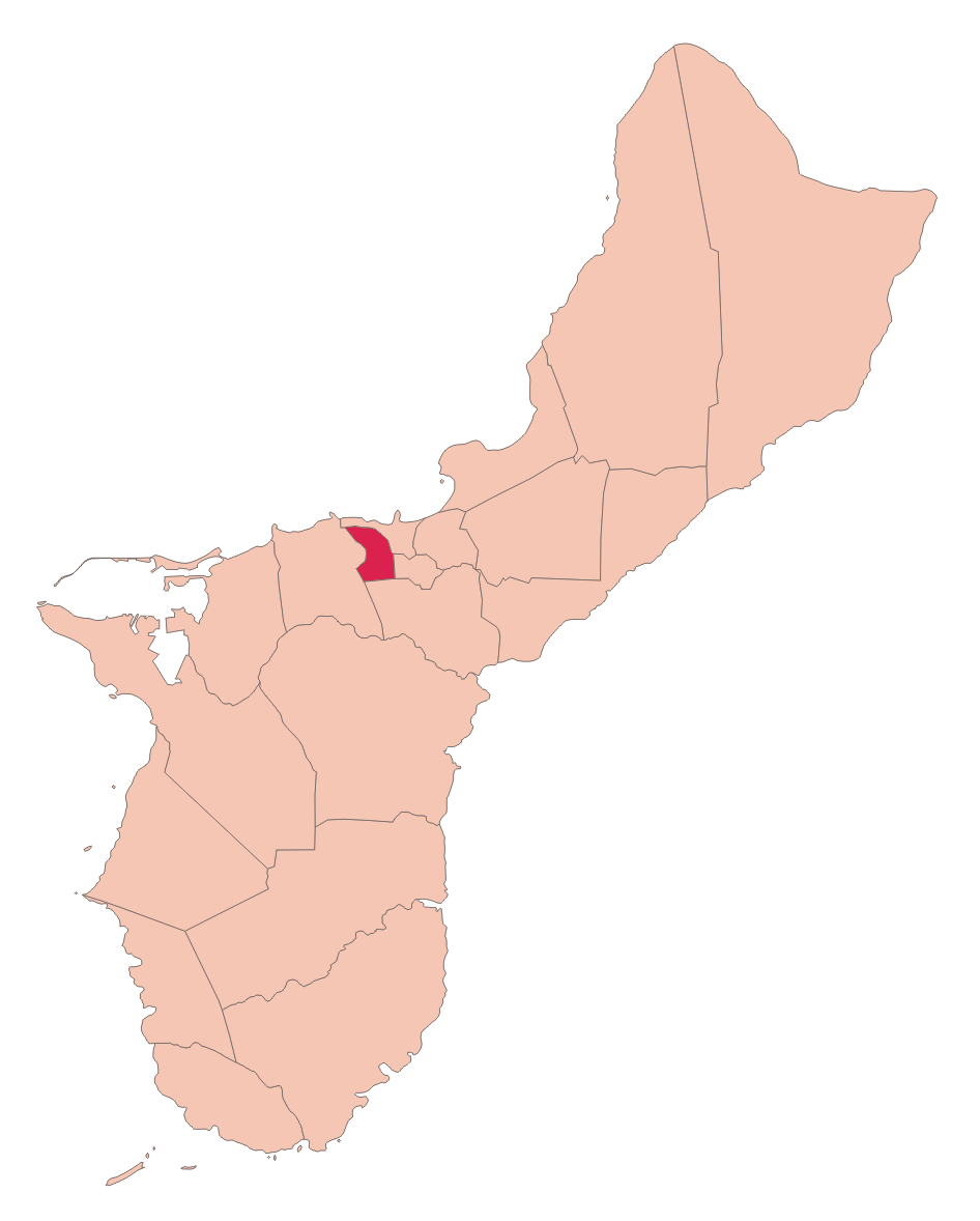
map_caption =Location of Agana Heights within the Territory of Guam.
latd= |latm= |lats= |latNS=
longd= |longm= |longs= |longEW=
elevation_ft =
official_name = Agana Heights


area_total_sq_mi =
population_total = 3940|population_footnotes=
population_as_of = 2000 [http://www.census.gov/Press-Release/www/2001/cb01cn174.html]
population_blank1 =
leader_title=Mayor
leader_name = Paul M. McDonald
Mayor_since =
leader_name1 =
blank_info = "Bougainvillea spectabilis"
Puti Tai Nobio
blank_name=Village Flower|

Agana Heights is one of the 19 villages of Guam. It lies in the hills south of Hagåtña (formerly Agana), in the central part of the island. The U.S. Naval Hospital is located in this largely residential village. [http://www.usnhguam.med.navy.mil/home.htm]

Education

The village is served by the Guam Public School System.

Agana Heights Elementary School is in Agana Heights. Jose Rios Middle School in Piti serves sections of Agana Heights south of Tutujan Drive. [http://web.archive.org/web/20060222192437/http://www.lk4kids.com/school+links.htm] George Washington High School in Mangilao serves the village." [http://www.gdoe.net/ci/high_sch_crse_desc/guam_PHS.pdf Guam's Public High Schools] ." "Guam Public School System". Accessed September 8, 2008.]

In addition, Department of Defense Education Activity operates Guam High School in Agana Heights.

References


Wikimedia Foundation. 2010.

Игры ⚽ Поможем решить контрольную работу

Look at other dictionaries:

  • Agana Heights Village — Original name in latin Agana Heights Village Name in other language Tutuhan State code GU Continent/City Pacific/Guam longitude 13.46559 latitude 144.74795 altitude 39 Population 3940 Date 2013 07 07 …   Cities with a population over 1000 database

  • Guam High School — is a U.S. military operated secondary school located at 401 Stitt Street in Agana Heights, Guam. [http://www.mwrguam.com/images/pdfs/80.pdf] The school, a part of the Department of Defense Education Activity, serves grades 9 through 12. The… …   Wikipedia

  • Agaña — Hagåtña Localización de Agaña en Guam …   Wikipedia Español

  • Guam Public School System — (GPSS, Chamorro: Sisteman Eskuelan Pupblekon Guåhan ), formerly the Guam Department of Education, is a school district that serves the entire island of Guam, a United States insular area. The school district can be thought of as analogous to the… …   Wikipedia

  • Guam — This article is about the United States island territory of Guam. For GUAM, an eastern European international organization, see GUAM Organization for Democracy and Economic Development. Guam Guåhan …   Wikipedia

  • Altos de Agaña — Agana Heights o Los altos de Agaña es una de las 19 localidades de Guam. Limita al sur con los montes de Agaña, de los cuales recibe su nombre. Un hospital naval del ejército de Estados Unidos se encuentra en este pueblo residencial. Historia Los …   Wikipedia Español

  • Wikiproyecto:Guam — Este wikiproyecto se encuentra inactivo Esto no significa que no puedas trabajar en los artículos de este tema por tu cuenta o que no haya otros haciendo lo mismo. También puedes animarte a buscar nuevos colaboradores, retirar esta plantilla y… …   Wikipedia Español

  • List of populated places in Guam — Guam This article is part of the series: Politics and government of Guam …   Wikipedia

  • Educación pública de Guam — Guam Public School System (en chamorro: Sisteman Eskuelan Pupblekon Guåhan), antiguamente el Departamento de educación de Guam, es un distrito escolar que sirve a la isla de Guam, una área insular perteneciente a los Estados Unidos de América. En …   Wikipedia Español

  • Geography of Guam — Guam Native name: Guåhån Map of Guam (See detailed map) …   Wikipedia

Share the article and excerpts

Direct link
Do a right-click on the link above
and select “Copy Link”