- Chickasaw National Recreation Area
-
Chickasaw National Recreation Area IUCN Category V (Protected Landscape/Seascape)

Location Murray County, Oklahoma, USA Nearest city Sulphur, OK Coordinates 34°30′2″N 96°58′20″W / 34.50056°N 96.97222°WCoordinates: 34°30′2″N 96°58′20″W / 34.50056°N 96.97222°W Area 9,888.83 acres (4,002 ha) Established July 1, 1902 Visitors 1,275,733 (in 2004) Governing body National Park Service Chickasaw National Recreation Areais a National Recreation Area situated in the foothills of the Arbuckle Mountains in south-central Oklahoma near Sulphur.
Contents
History
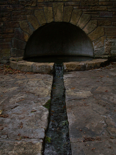
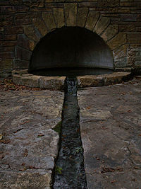 CCC stone work at Hillside Spring
Established as Sulphur Springs Reservation on July 1, 1902; renamed and redesignated Platt National Park on June 29, 1906; combined with the Arbuckle Recreation Area and additional lands and renamed and redesignated on 17 March 1976. Of the park's 9,888.83 acres (4,002 ha), water covers 2,409 acres (975 ha). The park contains many fine examples of 1930's Civilian Conservation Corps architecture. CCC workers created pavilions, park buildings, and enclosures for the park's many natural springs.[1]
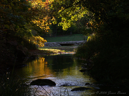
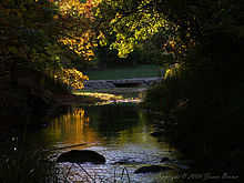 Travertine Creek, in the Chickasaw National Recreation Area, located in the foothills of the Arbuckles near Sulphur.
The Chickasaw National Recreation Area preserves partially forested hills of south-central Oklahoma near Sulphur. Named to honor the Chickasaw Indian Nation, who were relocated to the area from the Southeastern United States during the 1830s (and who later sold the original 640 acres (260 ha) of land for the park to the Federal government), the park's springs, streams, and lakes provide swimming, boating, fishing, picnicking, camping, and hiking. As part of the Chickasaw tribe's arrangement with the U.S. government, the park does not charge an admission fee.
Commemorative Coin
 This 2011 U.S. quarter features the Lincoln Bridge in the Chickasaw National Recreation Area.
In 2011, the United States Mint issued a quarter featuring the Chickasaw's Lincoln Bridge, a limestone bridge built in 1909 to commemorate the 100th birthday of Abraham Lincoln, as part of its America the Beautiful Quarters series.[2]
References
- ^ Chickasaw National Recreation Area - History & Culture (U.S. National Park Service)
- ^ Michael Overall, "Chickasaw quarter to debut as part of special coin series", Tulsa World, November 16, 2011.
- The National Parks: Index 2001-2003. Washington: U.S. Department of the Interior.
Further reading
- Hanson, R.L. and S.W. Cates. (1994). Hydrogeology of the Chickasaw National Recreation Area, Murray County, Oklahoma [Water-Resources Investigations Report 94-4102]. Oklahoma City: U.S. Department of the Interior, U.S. Geological Survey.
External links
- Official NPS website: Chickasaw National Recreation Area
- Encyclopedia of Oklahoma History and Culture - Chickasaw National Recreation Area
National Recreation Areas of the United States Administered by the
National Park ServiceAmistad • Big South Fork • Bighorn Canyon • Boston Harbor Islands • Chattahoochee River • Chickasaw • Curecanti • Delaware Water Gap • Gateway • Gauley River • Glen Canyon • Golden Gate • Lake Chelan • Lake Mead • Lake Meredith • Lake Roosevelt • Mississippi • Ross Lake • Santa Monica Mountains • Whiskeytown-Shasta-TrinityAdministered by
other agenciesAllegheny • Angel Peak • Arapaho • Datil Well • Flaming Gorge • Grand Island • Hells Canyon • Land Between The Lakes • Moosalamoo • Mount Baker • Mount Rogers • Oregon Dunes • Orilla Verde • Pine Ridge • Rattlesnake • Sawtooth • Smith River • Spring Mountains • Spruce Knob-Seneca Rocks • Valley of Fires • White Mountains • White Rocks • Wild Rivers • Winding Stair MountainFederal Chickasaw • Winding Stair MountainNational Forests:National Wildlife Refuges:Deep Fork • Little River • Optima • Ozark Plateau • Salt Plains • Sequoyah • Tishomingo • Washita • Wichita MountainsState Adair • Alabaster Caverns • Arrowhead • Beaver Dunes • Beavers Bend Resort Park • Bernice • Black Mesa • Boggy Depot • Boiling Springs • Boswell Lake • Brushy Lake • Cherokee • Cherokee Landing • Clayton Lake • Crowder Lake • Disney/Little Blue • Dripping Springs • Fort Cobb • Foss • Gloss Mountain • Great Plains • Great Salt Plains • Greenleaf • Heavener Runestone • Hochatown • Honey Creek • Hugo Lake • Keystone • Lake Eucha • Lake Eufaula • Lake Murray • Lake Texoma • Lake Wister • Lake Thunderbird • Little Sahara • McGee Creek • Natural Falls • Okmulgee • Osage Hills • Quartz Mountain • Raymond Gary • Red Rock Canyon • Robbers Cave • Roman Nose • Sequoyah Bay • Sequoyah/Western Hills • Snowdale • Spavinaw • Talimena • Tenkiller • Twin Bridges • Wah-Sha-She • Walnut CreekCategories:- IUCN Category V
- Protected areas of Murray County, Oklahoma
- United States National Park Service National Recreation Areas
- United States National Park Service areas in Oklahoma
- Civilian Conservation Corps in Oklahoma
- Oklahoma geography stubs
- United States National Park Service stubs


Wikimedia Foundation. 2010.