- Spruce Knob-Seneca Rocks National Recreation Area
Geobox|Protected Area
name = Spruce Knob-Seneca Rocks National Recreation Area
native_name =
other_name = Part ofMonongahela National Forest
other_name1 =
category =National Recreation Area
category_iucn =
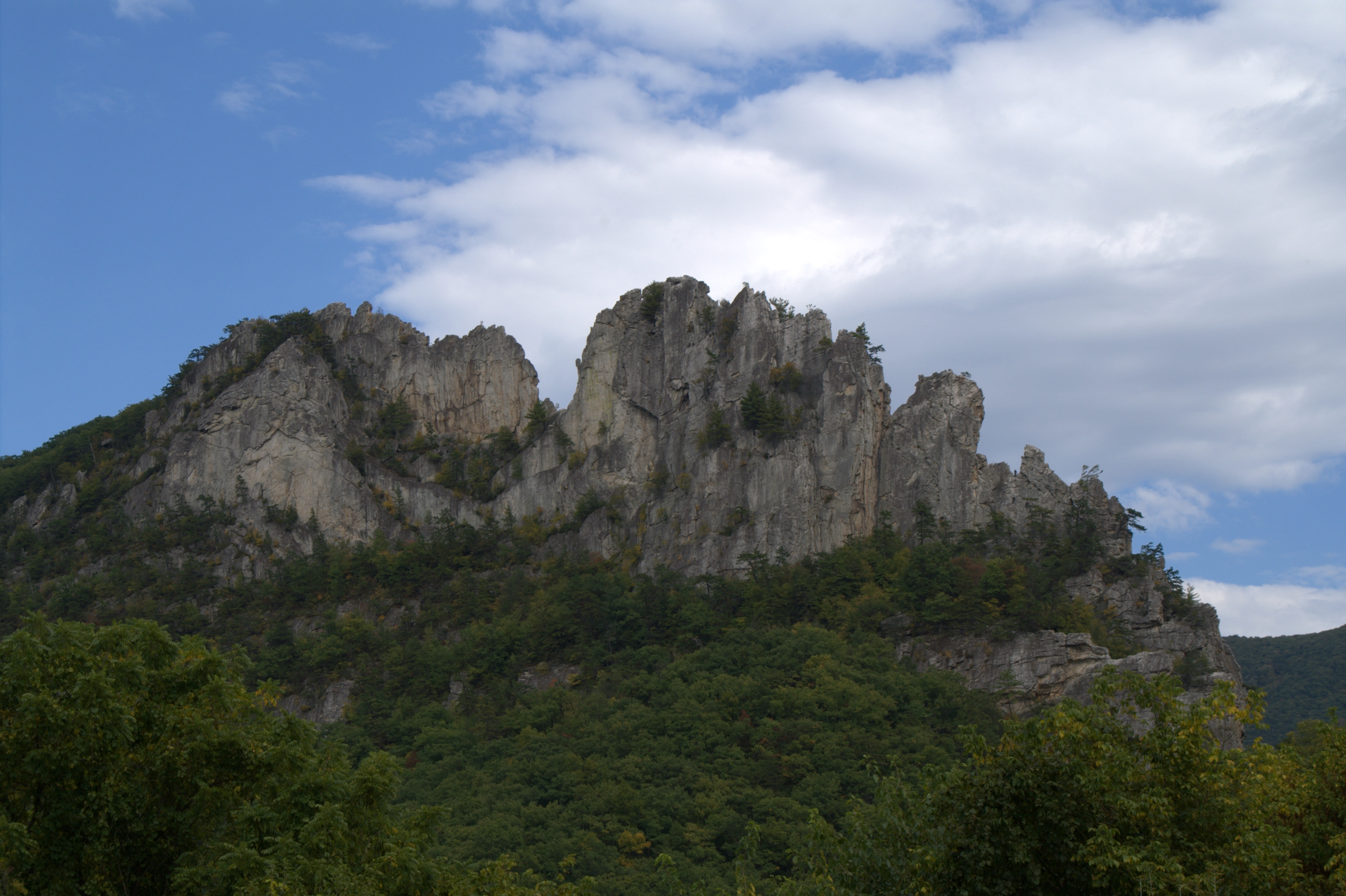
image_caption =Seneca Rocks
etymology_type =
etymology =
country = United States
country_
state = West Virginia
state_
region_type = Counties
region = Grant
region1 = Pendleton
district_type =
district =
district1 =
district2 =
city =
city1 =
location =Seneca Rocks
lat_d = 38
lat_m = 50
lat_s = 02
lat_NS = N
long_d = 79
long_m = 22
long_s = 04
long_EW = W
elevation_imperial = 1923
elevation_round = 1
area_unit = acre
area_imperial = 100000
area_note = [http://www.fs.fed.us/r9/mnf/sp/sksrnra.html Monongahela National Forest: Spruce Knob-Seneca Rocks National Recreation Area] , accessed April 12, 2008.]
area_round = 1
area1_imperial =
area1_type =
length_imperial =
length_orientation =
width_imperial =
width_orientation =
highest =Spruce Knob
highest_location = northwest of Circleville
highest_lat_d = 38
highest_lat_m = 41
highest_lat_s = 59
highest_lat_NS = N
highest_long_d = 79
highest_long_m = 31
highest_long_s = 58
highest_long_EW = W
highest_elevation_imperial = 4863
lowest =South Branch Potomac River
lowest_location = west of Petersburg
lowest_lat_d = 39
lowest_lat_m = 00
lowest_lat_s = 05
lowest_lat_NS = N
lowest_long_d = 79
lowest_long_m = 09
lowest_long_s = 46
lowest_long_EW = W
lowest_elevation_imperial = 968
biome =
biome_share =
biome1 =
biome1_share =
geology =
geology1 =
plant =
plant1 =
animal =
animal1 =
established_type = Established
established =1965-09-28
established1_type =
established1 =
owner =USDA Forest Service
management =Monongahela National Forest
management_location =
management_lat_d =
management_lat_m =
management_lat_s =
management_lat_NS =
management_long_d =
management_long_m =
management_long_s =
management_long_EW =
management_elevation =
visitation =
visitation_year =
free_type = Nearest city
free_label = Nearest city
free = Seneca Rocks,West Virginia
free1_type =
free1 =

map_caption = Location of Spruce Knob-Seneca Rocks National Recreation Area in West Virginia
map_locator = West Virginia
map_first =
website = [http://www.fs.fed.us/r9/mnf/sp/sksrnra.html Spruce Knob-Seneca Rocks National Recreation Area]Spruce Knob-Seneca Rocks National Recreation Area is a
U.S. National Recreation Area (NRA) located within theMonongahela National Forest of easternWest Virginia , USA.The NRA protects two prominent West Virginia landmarks:
Spruce Knob , the highest point in West Virginia (and the highest of theAllegheny Mountains ) with a summit elevation of 4,863 feet (1482 m), andSeneca Rocks , a 900 foot (270 m) highquartzite crag popular withrock climbers .Spruce Knob-Seneca Rocks NRA was established by an act of the
U.S. Congress on September 28, 1965 as the first National Recreation Area in aUnited States National Forest . It is therefore administered by theUS Forest Service rather than theNational Park Service , as most other National Recreation Areas are.External links
* [http://www.fs.fed.us/r9/mnf/sp/sksrnra.html Spruce Knob-Seneca Rocks National Recreation Area official site]

Wikimedia Foundation. 2010.