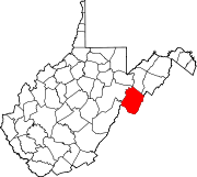
- Circleville, West Virginia
-
Circleville — Unincorporated community — Location within the state of West Virginia Coordinates: 38°40′15″N 79°29′28″W / 38.67083°N 79.49111°WCoordinates: 38°40′15″N 79°29′28″W / 38.67083°N 79.49111°W Country United States State West Virginia County Pendleton Time zone Eastern (EST) (UTC-5) – Summer (DST) EDT (UTC-4) ZIP codes FIPS code GNIS feature ID Circleville is an unincorporated community located in Pendleton County, West Virginia, USA. Circleville was named for a Mr. Zirkle who once kept a store here. The old Circleville School is listed on the National Register of Historic Places.[1]
Circleville is located on West Virginia Route 28 along the North Fork South Branch Potomac River at its confluence with Pike Gap and Bouses Runs.
References
- ^ "National Register Information System". National Register of Historic Places. National Park Service. 2010-07-09. http://nrhp.focus.nps.gov/natreg/docs/All_Data.html.
Municipalities and communities of Pendleton County, West Virginia Town CDP Unincorporated
communitiesBrushy Run | Cave | Cherry Grove | Circleville | Dahmer | Deer Run | Dry Run | Entry | Fame | Fort Seybert | Harper | Judy Gap | Ketterman | Kline | Macksville | Miles | Mitchell | Moatstown | Monkeytown | Moyers | Mozer | Oak Flat | Oak Grove | Onego | Propstburg | Riverton | Ruddle | Seneca Rocks | Simoda | Sugar Grove | Teterton | Upper Tract | Zigler
Categories:- Potomac Highlands geography stubs
- Populated places in Pendleton County, West Virginia
- Unincorporated communities in West Virginia
Wikimedia Foundation. 2010.


