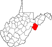
- Cherry Grove, West Virginia
-
Cherry Grove — Unincorporated community — Location within the state of West Virginia Coordinates: 38°38′26″N 79°31′22″W / 38.64056°N 79.52278°WCoordinates: 38°38′26″N 79°31′22″W / 38.64056°N 79.52278°W Country United States State West Virginia County Pendleton Time zone Eastern (EST) (UTC-5) – Summer (DST) EDT (UTC-4) ZIP codes FIPS code GNIS feature ID Cherry Grove is an unincorporated community located in Pendleton County, West Virginia, USA. Cherry Grove lies within the Monongahela National Forest at the confluence of Big Run with the North Fork South Branch Potomac River.
According to the Geographic Names Information System, Cherry Grove has also been known throughout its history as Big Run, Big Run School, Champe Rocks, Mullenax, Mullenun, and Mullenux.
Municipalities and communities of Pendleton County, West Virginia Town CDP Unincorporated
communitiesBrushy Run | Cave | Cherry Grove | Circleville | Dahmer | Deer Run | Dry Run | Entry | Fame | Fort Seybert | Harper | Judy Gap | Ketterman | Kline | Macksville | Miles | Mitchell | Moatstown | Monkeytown | Moyers | Mozer | Oak Flat | Oak Grove | Onego | Propstburg | Riverton | Ruddle | Seneca Rocks | Simoda | Sugar Grove | Teterton | Upper Tract | Zigler
Categories:- Potomac Highlands geography stubs
- Populated places in Pendleton County, West Virginia
- Unincorporated communities in West Virginia
Wikimedia Foundation. 2010.


