- Okmulgee County, Oklahoma
-
Okmulgee County, Oklahoma 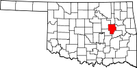
Location in the state of Oklahoma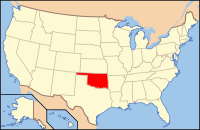
Oklahoma's location in the U.S.Founded information needed Seat Okmulgee Area
- Total
- Land
- Water
702 sq mi (1,818 km²)
697 sq mi (1,805 km²)
5 sq mi (13 km²), 0.76%Population
- (2000)
- Density
39,685
57/sq mi (22/km²)Okmulgee County is a county located in the U.S. state of Oklahoma. As of 2000, the population was 39,685. Its county seat is Okmulgee[1].
Contents
History
Okmulgee County was formed on July 16, 1907, from Muskogee land.
Geography
According to the U.S. Census Bureau, the county has a total area of 1,819 km² (702 mi²). 1,805 km² (697 mi²) of it is land and 14 km² (5 mi²) of it (0.76%) is water.
Adjacent counties
- Tulsa County (north)
- Wagoner County (northeast)
- Muskogee County (east)
- McIntosh County (southeast)
- Okfuskee County (southwest)
- Creek County (northwest)
Government
The county is governed by a three-person Board of Commissioners.
Demographics
As of the census[2] of 2000, there were 39,685 people, 15,300 households, and 10,694 families residing in the county. The population density was 22/km² (57/mi²). There were 17,316 housing units at an average density of 10/km² (25/mi²). The racial makeup of the county was 69.73% White, 10.20% Black or African American, 12.85% Native American, 0.19% Asian, 0.02% Pacific Islander, 0.61% from other races, and 6.40% from two or more races. 1.95% of the population were Hispanic or Latino of any race.
There were 15,300 households out of which 32.00% had children under the age of 18 living with them, 52.80% were married couples living together, 13.10% had a female householder with no husband present, and 30.10% were non-families. 27.10% of all households were made up of individuals and 12.60% had someone living alone who was 65 years of age or older. The average household size was 2.53 and the average family size was 3.06.
In the county, the population was spread out with 26.90% under the age of 18, 9.50% from 18 to 24, 25.30% from 25 to 44, 23.30% from 45 to 64, and 15.10% who were 65 years of age or older. The median age was 37 years. For every 100 females there were 95.20 males. For every 100 females age 18 and over, there were 90.80 males.
The median income for a household in the county was $27,652, and the median income for a family was $33,987. Males had a median income of $29,935 versus $20,861 for females. The per capita income for the county was $14,065. About 14.90% of families and 18.90% of the population were below the poverty line, including 24.90% of those under age 18 and 15.50% of those age 65 or over.
Cities and towns
NRHP Sites
The following sites in Okmulgee County are listed on the National Register of Historic Places:
- Creek National Capitol, Okmulgee
- Eastside Baptist Church, Okmulgee
- First Baptist Central Church, Okmulgee
- Harmon Athletic Field, Okmulgee
- Hugh Henry House, Henryetta
- Isparhecher House and Grave, Beggs
- Lake Okmulgee Dam Spillway Cascade, Okmulgee
- Nuyaka Mission, Okmulgee
- Okmulgee Armory, Okmulgee
- Okmulgee Black Hospital, Okmulgee
- Okmulgee County Courthouse, Okmulgee
- Okmulgee Downtown Historic District
- Okmulgee Public Library, Okmulgee
- Okmulgee Stock Pavilion, Okmulgee
- Severs Block, Okmulgee
- St. Anthony's Catholic Church, Okmulgee
- Wilson School, Henryetta
References
- ^ "Find a County". National Association of Counties. http://www.naco.org/Counties/Pages/FindACounty.aspx. Retrieved 2011-06-07.
- ^ "American FactFinder". United States Census Bureau. http://factfinder.census.gov. Retrieved 2008-01-31.
Municipalities and communities of Okmulgee County, Oklahoma Cities 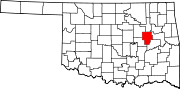
Towns Unincorporated
communitiesBaldhill | Bartlett | Bryant | Coalton | Dighton | Eram | Four Corners | Gulftown | Kusa | Natura | Nuyaka | Preston | Pumpkin Center | Spelter City | Wilson
Footnotes ‡This populated place also has portions in an adjacent county or counties
Categories:- Oklahoma counties
- Okmulgee County, Oklahoma
- 1907 establishments in the United States
- Populated places established in 1907
- Tulsa Metropolitan Area


Wikimedia Foundation. 2010.