- McCurtain County, Oklahoma
-
McCurtain County, Oklahoma 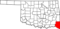
Location in the state of Oklahoma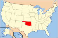
Oklahoma's location in the U.S.Founded 1907 Seat Idabel Area
- Total
- Land
- Water
1,901 sq mi (4,924 km²)
1,852 sq mi (4,797 km²)
49 sq mi (127 km²), 2.58%Population
- (2010)
- Density
33,151
18/sq mi (7/km²)McCurtain County is a county located in the U.S. state of Oklahoma. As of 2010, the population was 33,151. Its county seat is Idabel[1].
Contents
Geography
The county has a total area of 4,924 km² (1,901 mi²). 4,797 km² (1,852 mi²) of it is land and 127 km² (49 mi²) of it (2.58%) is water. The terrain of McCurtain county varies from the mountainous northern part of the county to the rich Red River bottoms of the southern part. Sections of the Mountain Fork and Little River drainages lie in McCurtain county. The Mountain Fork river is one of the two year round trout fisheries in the state. The lowest point in the state of Oklahoma is located on the Little River in McCurtain County, where it flows out of Oklahoma and into Arkansas.
Major highways
 U.S. Highway 70
 U.S. Highway 259
 State Highway 3
 State Highway 37
 State Highway 98
Adjacent counties
- Le Flore County, Oklahoma (north)
- Polk County, Arkansas (northeast)
- Sevier County, Arkansas (east)
- Little River County, Arkansas (southeast)
- Bowie County, Texas (south)
- Red River County, Texas (southwest)
- Choctaw County, Oklahoma (west)
- Pushmataha County, Oklahoma (northwest)
National protected areas
- Little River National Wildlife Refuge
- Ouachita National Forest (part)
Demographics
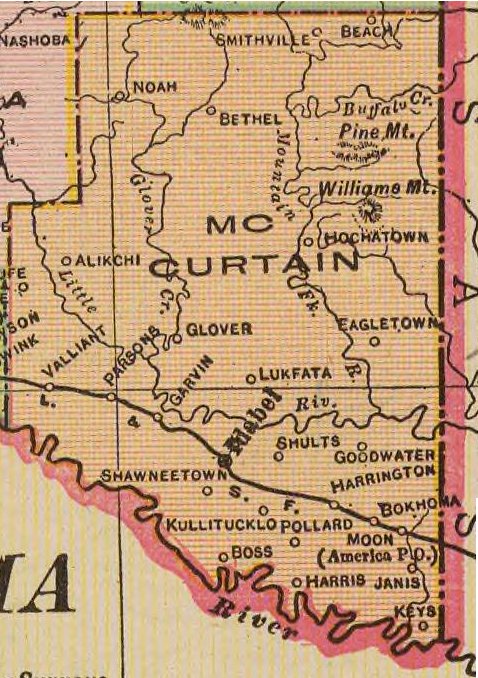
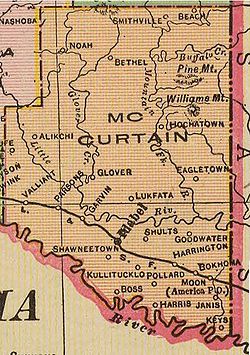 Map of McCurtain County, 1909
As of the census[2] of 2000, there were 34,402 people, 13,216 households, and 9,541 families residing in the county. The population density was 7/km² (19/mi²). There were 15,427 housing units at an average density of 3/km² (8/mi²). The racial makeup of the county was 70.54% White, 9.30% Black or African American, 13.57% Native American, 0.22% Asian, 0.01% Pacific Islander, 1.34% from other races, and 5.02% from two or more races. 3.09% of the population were Hispanic or Latino of any race. 28.6% were of American, 7.6% Irish and 5.9% English ancestry according to Census 2000. 94.4% spoke English, 2.9% Spanish and 2.6% Choctaw as their first language.
There were 13,216 households out of which 34.00% had children under the age of 18 living with them, 53.30% were married couples living together, 14.60% had a female householder with no husband present, and 27.80% were non-families. 25.40% of all households were made up of individuals and 11.00% had someone living alone who was 65 years of age or older. The average household size was 2.56 and the average family size was 3.06.
In the county, the population was spread out with 28.20% under the age of 18, 8.30% from 18 to 24, 26.20% from 25 to 44, 23.40% from 45 to 64, and 14.00% who were 65 years of age or older. The median age was 36 years. For every 100 females there were 92.80 males. For every 100 females age 18 and over, there were 89.10 males.
The median income for a household in the county was $24,162, and the median income for a family was $29,933. Males had a median income of $26,528 versus $17,869 for females. The per capita income for the county was $13,693. About 21.00% of families and 24.70% of the population were below the poverty line, including 32.40% of those under age 18 and 21.20% of those age 65 or over.
Cities and towns
- Battiest
- Broken Bow
- Eagletown
- Garvin
- Haworth
- Idabel
- Millerton
- Pickens
- Smithville
- Tom
- Valliant
- Watson
- Wright City
See also
References
- ^ "Find a County". National Association of Counties. http://www.naco.org/Counties/Pages/FindACounty.aspx. Retrieved 2011-06-07.
- ^ "American FactFinder". United States Census Bureau. http://factfinder.census.gov. Retrieved 2008-01-31.
External links
- McCurtain County OSU Extension Center
- Beavers Bend Cabins near Broken Bow Lake and Beavers Bend State Park
Municipalities and communities of McCurtain County, Oklahoma Cities 
Towns Garvin | Haworth | Millerton | Smithville | Valliant | Wright City
Unincorporated
communitiesBattiest | Beachton | Bethel | Bokhoma | Boss | Buffalo | Burwell | Cerrogordo | Cisco | Clebit | Eagletown | Farmers Hill | Felker | Glover | Golden | Goodwater | Harris | Holley Creek | Iron Stob Corner | Kulli/Kullituklo | Moon | Mound Grove | Mount Herman | Mount Zion | Pickens | Pleasant Hill | Plucketville | Pollard | Ringold | Rufe | Sherwood | Shinewell | Shults | Smithville | Steel Junction | Tablerville | Tiner | Tom | Ultima Thule | Watson
Ghost towns America | Slim | Miller Court House
Categories:- Oklahoma counties
- McCurtain County, Oklahoma
- 1907 establishments in the United States
- Populated places established in 1907


Wikimedia Foundation. 2010.