- Mountain Fork
-
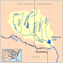
Mountain Fork, also known as the Mountain Fork of the Little River, is a 98-mile-long (158 km)[1] tributary of the Little River in western Arkansas and southeastern Oklahoma in the United States. Via the Little and Red rivers, it is part of the watershed of the Mississippi River.
Contents
Course
It rises in Le Flore County, Oklahoma, in the Ouachita Mountains, and flows southeastwardly into Polk County, Arkansas, then southwestwardly into McCurtain County, Oklahoma, where it turns southward for the remainder of its course. It joins the Little River in McCurtain County, 10 miles (16 km) southeast of Broken Bow.
In its upper course, the river flows through a portion of the Ouachita National Forest. In McCurtain County, the river is dammed to form Broken Bow Lake.
See also
- List of Arkansas rivers
- List of Oklahoma rivers
References
- ^ U.S. Geological Survey. National Hydrography Dataset high-resolution flowline data. The National Map, accessed June 3, 2011
- Columbia Gazetteer of North America
- DeLorme (2004). Arkansas Atlas & Gazetteer. Yarmouth, Maine: DeLorme. ISBN 0-89933-345-1.
- DeLorme (2003). Oklahoma Atlas & Gazetteer. Yarmouth, Maine: DeLorme. ISBN 0-89933-283-8.
- U.S. Geological Survey Geographic Names Information System: Mountain Fork
External links
Categories:- Rivers of Arkansas
- Rivers of Oklahoma
- Geography of Le Flore County, Oklahoma
- Geography of McCurtain County, Oklahoma
- Geography of Polk County, Arkansas
- Tributaries of the Red River (Mississippi River)
Wikimedia Foundation. 2010.

