- Custer County, Oklahoma
-
Custer County, Oklahoma 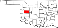
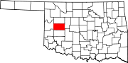
Location in the state of Oklahoma
Oklahoma's location in the U.S.Founded 1892 Named for General George A. Custer Seat Arapaho Largest city Weatherford Area
- Total
- Land
- Water
1,002 sq mi (2,595 km²)
987 sq mi (2,555 km²)
15 sq mi (40 km²), 1.55Population
- (2000)
- Density
26,142
26/sq mi (10/km²)Congressional district 3rd Time zone Central: UTC-6/-5 Website www.custercountyok.org/ Custer County is a county located in the U.S. state of Oklahoma. It was named in honor of General George Armstrong Custer. As of 2000, the population was 26,142. Its county seat is Arapaho[1].
Contents
Geography
According to the U.S. Census Bureau, the county has a total area of 1,002 square miles (2,595.2 km2), of which 987 square miles (2,556.3 km2) is land and 15 square miles (38.8 km2) (1.55%) is water.
Major highways
 Interstate 40
 U.S. Highway 183
 State Highway 33
 State Highway 44
 State Highway 47
 State Highway 54
 State Highway 73
Adjacent counties
- Dewey County (north)
- Blaine County (east)
- Caddo County (southeast)
- Washita County (south)
- Beckham County (southwest)
- Roger Mills County (west)
National protected area
- Washita National Wildlife Refuge
History
Custer County was formed on April 19, 1892 as an original county from Cheyenne land, and called G County. On November 6, 1896 it was renamed Custer County after General George Armstrong Custer, who was killed at the Battle of Little Bighorn. The county was settled by white settlers during the third official land run of April 19, 1892. On this day the first newspaper of the county appeared, the Arapaho Arrow.
Demographics
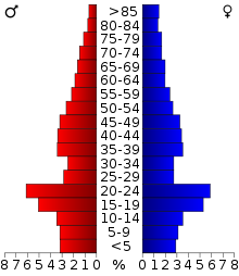 Age pyramid for Custer County, Oklahoma, based on census 2000 data.
As of the census[2] of 2000, there were 26,142 people, 10,136 households, and 6,578 families residing in the county. The population density was 26 people per square mile (10/km²). There were 11,675 housing units at an average density of 12 per square mile (5/km²). The racial makeup of the county was 81.41% White, 2.87% Black or African American, 5.81% Native American, 0.88% Asian, 0.04% Pacific Islander, 5.80% from other races, and 3.20% from two or more races. 9.03% of the population were Hispanic or Latino of any race.
There were 10,136 households out of which 30.20% had children under the age of 18 living with them, 51.60% were married couples living together, 9.50% had a female householder with no husband present, and 35.10% were non-families. 27.80% of all households were made up of individuals and 10.80% had someone living alone who was 65 years of age or older. The average household size was 2.45 and the average family size was 3.05.
In the county, the population was spread out with 24.30% under the age of 18, 17.40% from 18 to 24, 24.50% from 25 to 44, 20.10% from 45 to 64, and 13.70% who were 65 years of age or older. The median age was 33 years. For every 100 females there were 94.90 males. For every 100 females age 18 and over, there were 92.00 males.
The median income for a household in the county was $28,524, and the median income for a family was $37,247. Males had a median income of $27,066 versus $19,479 for females. The per capita income for the county was $15,584. About 12.40% of families and 18.50% of the population were below the poverty line, including 21.00% of those under age 18 and 10.50% of those age 65 or over.
Cities and towns
See also
References
- ^ "Find a County". National Association of Counties. http://www.naco.org/Counties/Pages/FindACounty.aspx. Retrieved 2011-06-07.
- ^ "American FactFinder". United States Census Bureau. http://factfinder.census.gov. Retrieved 2008-01-31.
External links
Municipalities and communities of Custer County, Oklahoma Cities Clinton‡ | Thomas | Weatherford
Towns Arapaho | Butler | Custer City | Hammon‡
Unincorporated
communitiesAnthon | Cody | Carpenter‡ | Dead Women Crossing | East Junction | Eastside | Ewing | Foley | Hammon Junction | McClure | Moorewood | Parkersburg | Ralph | Stafford | Sunset
Ghost town Independence | Osceola
Footnotes ‡This populated place also has portions in an adjacent county or counties
Categories:- Oklahoma counties
- Custer County, Oklahoma
- 1892 establishments


Wikimedia Foundation. 2010.