- Oklahoma County, Oklahoma
-
Oklahoma County, Oklahoma 
Seal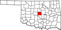
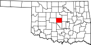
Location in the state of Oklahoma
Oklahoma's location in the U.S.Founded 1890 Seat Oklahoma City Area
- Total
- Land
- Water
718 sq mi (1,860 km²)
709 sq mi (1,836 km²)
9 sq mi (23 km²), 1.28%Population
- (2010)
- Density
718,633
1,013/sq mi (391/km²)Website www.oklahomacounty.org Oklahoma County is a county located in the central part of the U.S. state of Oklahoma. The population was 718,633 at the 2010 census. The county seat and principal city is Oklahoma City[1]. Oklahoma County is at the heart of the Oklahoma City Metropolitan Statistical Area and is the most populous county in the state.
Oklahoma County is one of seven US counties to share its name with its state (the others are Arkansas County, Hawaii County, Idaho County, Iowa County, New York County and Utah County).
Contents
History
Oklahoma County was originally called County Two and was one of seven counties established by the Organic Act of 1890.[2]
County business initially took place in a building at the intersection of California Avenue and Robinson Street until the construction of the first Oklahoma County Courthouse at 520 West Main Street in the 1900s. In 1937, the county government was moved to a building at 321 Park Avenue, which now serves only as the county courthouse.[3]
Geography
According to the U.S. Census Bureau, the county has a total area of 718 square miles (1,860 km2), of which 709 square miles (1,840 km2) is land and 9 square miles (23 km2) (1.28%) is water.
Major highways
 Interstate 35
 Interstate 40
 Interstate 44
 Interstate 235
 Interstate 240
 U.S. Highway 62
 U.S. Highway 77
 U.S. Highway 270
 State Highway 66
 State Highway 74
 State Highway 3
- Kilpatrick Turnpike
- Turner Turnpike
Adjacent counties
- Logan County (north)
- Lincoln County (east)
- Pottawatomie County (southeast)
- Cleveland County (south)
- Canadian County (west)
- Kingfisher County (northwest)
National protected area
Demographics
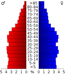 Age pyramid for Oklahoma County, Oklahoma, based on census 2000 data.
As of the census[4] of 2000, there were 660,448 people, 266,834 households, and 170,773 families residing in the county. The population density was 931 people per square mile (360/km²). There were 295,020 housing units at an average density of 416 per square mile (161/km²). The racial makeup of the county was 70.44% White, 15.03% Black or African American, 3.42% Native American, 2.81% Asian, 0.08% Pacific Islander, 4.36% from other races, and 3.87% from two or more races. 8.68% of the population were Hispanic or Latino of any race.
There were 266,834 households out of which 30.90% had children under the age of 18 living with them, 46.30% were married couples living together, 13.50% had a female householder with no husband present, and 36.00% were non-families. 30.20% of all households were made up of individuals and 9.20% had someone living alone who was 65 years of age or older. The average household size was 2.41 and the average family size was 3.02.
In the county, the population was spread out with 25.60% under the age of 18, 10.90% from 18 to 24, 30.00% from 25 to 44, 21.40% from 45 to 64, and 12.20% who were 65 years of age or older. The median age was 34 years. For every 100 females there were 94.20 males. For every 100 females age 18 and over, there were 90.80 males.
The median income for a household in the county was $35,063, and the median income for a family was $42,797. Males had a median income of $31,660 versus $24,279 for females. The per capita income for the county was $19,551. About 11.70% of families and 15.30% of the population were below the poverty line, including 21.70% of those under age 18 and 8.60% of those age 65 or over.
Cities and towns
- Arcadia
- Bethany
- Choctaw
- Del City
- Edmond
- Forest Park
- Harrah
- Jones
- Lake Aluma
- Luther
- Midwest City
- Nichols Hills
- Nicoma Park
- Oklahoma City
- Smith Village
- Spencer
- The Village
- Valley Brook
- Warr Acres
- Woodlawn Park
See also
References
- ^ "Find a County". National Association of Counties. http://www.naco.org/Counties/Pages/FindACounty.aspx. Retrieved 2011-06-07.
- ^ Wilson, Linda D. "Oklahoma County." Encyclopedia of Oklahoma History and Culture. Accessed 2009 September 17.
- ^ "A Brief History of Oklahoma County Government." OklahomaCounty.org. Accessed 2009 September 17.
- ^ "American FactFinder". United States Census Bureau. http://factfinder.census.gov. Retrieved 2008-01-31.
External links

Kingfisher County Logan County Canadian County 
Lincoln County  Oklahoma County, Oklahoma

Cleveland County Pottawatomie County Municipalities and communities of Oklahoma County, Oklahoma Cities Bethany | Choctaw | Del City | Edmond | Harrah | Midwest City | Nichols Hills | Nicoma Park | Oklahoma City‡ | Spencer | The Village | Warr Acres
Towns Arcadia | Forest Park | Jones | Lake Aluma | Luther | Smith Village | Valley Brook | Woodlawn Park
Unincorporated
communitiesLake Hiawasse | Newalla | Woods
Footnotes ‡This populated place also has portions in an adjacent county or counties
Municipalities of the Greater Oklahoma City Metropolitan Area Population over 500,000 Population over 100,000 Population over 50,000 Population over 20,000 Population over 10,000 Population over 5,000 Population over 2,000 Bethel Acres • Chandler • Harrah • Jones • Lexington • McLoud • Nichols Hills • Nicoma Park • Prague • Slaughterville • Spencer • StroudPopulation over 1,000 Crescent • Forest Park • Goldsby • Langston • Luther • Maud • Minco • Ninnekah • Okarche • Pink • Rush Springs • Union CityPopulation over 500 Population over 200 Population under 200 Bradley • Bridge Creek • Brooksville • Cimarron City • Etowah • Fallis • Kendrick • Lake Aluma • Macomb • Meridian • Norge • Rosedale • Smith Village • Sparks • Woodlawn ParkUnincorporated areas Regional Government Association of Central Oklahoma GovernmentsCategories:- Oklahoma counties
- Oklahoma City Metropolitan Area
- Oklahoma County, Oklahoma
- 1890 establishments


Wikimedia Foundation. 2010.