- Hawaii County, Hawaii
-
Hawaii County, Hawaii 
Seal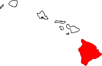
Location in the state of Hawaii
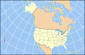
Hawaii's location in the U.S.Founded 1905 Seat Hilo Largest city Hilo Area
- Total
- Land
- Water
5,086.70 sq mi (13,174 km²)
4,028.02 sq mi (10,433 km²)
1,058.69 sq mi (2,742 km²), ?%Population
- (2010)
- Density
185,079
46/sq mi (17.7/km²)Congressional district 2nd Time zone Hawaii-Aleutian: UTC-10 Website co.hawaii.hi.us Hawaiʻi County is a county located in the U.S. state of Hawaii in the Hawaiian Islands. It is coterminous with the Island of Hawaiʻi, often called the "Big Island" to distinguish it from the state as a whole. As of the 2010 Census the population was 185,079. The county seat is Hilo. There are no incorporated cities in Hawaiʻi County (see Hawaii Counties). The Hilo Micropolitan Statistical Area includes all of Hawaiʻi County. Hawaiʻi County has a mayor-council form of government.
Hawaii County is one of seven US counties to share its name with its state (the others are Arkansas County, Idaho County, Iowa County, New York County, Oklahoma County, and Utah County).
Contents
Geography
Hawaiʻi County has a total area of 5,086.70 square miles (13,174.5 km2); 4,028.02 square miles (10,432.5 km2) is land and 1,058.69 square miles (2,742.0 km2) is water[1] (mostly all off the ocean shoreline but counted in the total area by the U.S. Census Bureau). The county's land area comprises 62.7 percent of the state's land area. It is the highest percentage by any county in the United States. (Delaware's Sussex County comes in second at 48.0 percent, while Rhode Island's Providence County is third at 39.55 percent.)
Adjacent counties
- Maui County - northwest
Government and infrastructure
County government
Executive authority is vested in the Mayor of Hawaii County who is elected for a four-year term. Since 2004, the election by the voters has been on a non-partisan basis. In 2008, William "Billy" Kenoi was elected Mayor, succeeding Harry Kim who had served a two-term limit.[2] Legislative authority is vested in a nine-member County Council. Each member represents a geographical region of the island, which closely correlates to one of the nine tax map districts of Hawaiʻi County. Members of the County Council are elected on a non-partisan basis to two-year terms, with the latest election occurring in November of 2010.
Administrative districts were originally based on the traditional land divisions called Moku of Ancient Hawaii. Some of the more heavily populated districts have since been split into North and South districts to make them more comparable on a population basis.
The number following each district is the Tax Map Key (TMK) number, used to locate state property information. They are assigned in a counter-clockwise order beginning on the eastern side of the island.[3]
Nr. District Area
mi²Population
2000moku 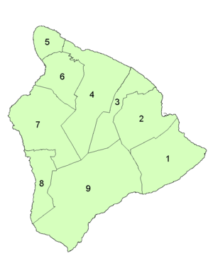 District subdivision of Hawaii County
1 Puna 499.45 31335 Puna 2 South Hilo 394.38 47386 Hilo 3 North Hilo 370.65 1720 Hilo 4 Hāmākua 580.50 6108 Hāmākua 5 North Kohala 132.92 6038 Kohala 6 South Kohala 351.72 13131 Kohala 7 North Kona 489.01 28543 Kona 8 South Kona 335.38 8589 Kona 9 edit] State government Hawaii Department of Public Safety previously operated the Kulani Correctional Facility in Hawaii County, on the Island of Hawaii.[6] In 2009, the Hawaii Department of Public Safety announced that Kulani Correctional Facility would close.[7]
Localities
Census-designated places
- Pahala
- Pahoa
- Papaikou
- Pepeekeo
- Paukaa
- Puako
- Volcano
- Waikoloa Village
- Waimea
- Wainaku
Other communities
National protected areas
- Ala Kahakai National Historic Trail
- Hakalau Forest National Wildlife Refuge
- Hawaiʻi Volcanoes National Park
- Honokōhau Settlement and Kaloko-Honokōhau National Historical Park
- Kona Forest National Wildlife Refuge
- Puʻuhonua o Hōnaunau National Historical Park
- Puʻukoholā Heiau National Historic Site
Economy
Top employers
According to the County's 2010 Comprehensive Annual Financial Report,[8] the top employers in the county are:
# Employer # of Employees 1 State of Hawaii 8,115 2 Hawaii County 2,745 3 United States Government 1,364 4 Hilton Waikoloa Village 984 5 Wal-Mart 852 6 KTA Super Stores 800 7 Mauna Loa Resort 685 8 The Fairmont Orchid 577 9 Four Seasons Resort Hualalai 562 10 Hapuna Beach Prince Hotel 487 Sister cities
Hawaii County has 10 sisters:[9]
- Hualien City, Taiwan (1971)
- La Serena, Chile (1994)
- Legazpi City, Philippines (1970)
- Nago City, Okinawa, Japan (1986)
- Oshima, Japan (1962)
- Sao Miguel Island, Portugal (1980)
- Shibukawa, Gunma Prefecture, Japan (1997)
- Sumoto, Japan (2000)
- Tasmania, Australia (1997)
- Yurihama, Tottori Prefecture, Japan (1996)
References
- ^ "Census 2000 U.S. Gazetteer Files: Counties". United States Census. http://www.census.gov/tiger/tms/gazetteer/county2k.txt. Retrieved 2011-02-13.
- ^ "Office of the Mayor". official web site. County of Hawaii. http://www.co.hawaii.hi.us/directory/dir_mayors.htm. Retrieved 2010-03-27.
- ^ Hawaii County: 2000
- ^ "Hawaiʻi County Council". official web site. http://www.co.hawaii.hi.us/council/districts.htm. Retrieved 2010-03-27.
- ^ "Office of Liquor Control". Hawaii County web site. http://www.hawaii-county.com/directory/dir_liquor.htm. Retrieved December 25, 2010.
- ^ "Kulani Correctional Facility." Hawaii Department of Public Safety. Retrieved on September 30, 2010.
- ^ "Closure of Kulani Saves $2.8M Annually; Facility to Help At-Risk Youth." Hawaii Department of Public Safety. July 2009. Retrieved on September 30, 2010.
- ^ County of Hawaii CAFR
- ^ State of Hawaii’s Sister States/Cities A Report to the Hawaii State Legislature 2006
External links
- County website
- Mayor's office
- Volcanoes National Park
- [www.co.hawaii.hi.us/general_plan_rev/revision/economic.doc Economic background from the Revision of the Hawaii County General Plan]
Municipalities and communities of Hawaii County, Hawaii CDPs Ainaloa | Captain Cook | Eden Roc | Fern Acres | Fern Forest | Halaula | Hawaiian Acres | Hawaiian Beaches | Hawaiian Ocean View | Hawaiian Paradise Park | Hawi | Hilo | Holualoa | Honalo | Honaunau-Napoopoo | Honokaa | Honomu | Kahaluu-Keauhou | Kailua | Kalaoa | Kapaau | Keaau | Kealakekua | Kukuihaele | Kurtistown | Laupāhoehoe | Leilani Estates | Mountain View | Naalehu | Nanawale Estates | Orchidlands Estates | Paauilo | Pahala | Pahoa | Papaikou | Pepeekeo | Paukaa | Puako | Volcano | Waikoloa Village | Waimea | Wainaku

Unincorporated
communitiesDistricts  State of Hawaii
Topics - Geography
- Government
- Delegations
- History
- Islands
- Music
- Language
- People
- Visitor Attractions
Society Main Islands Northwestern
IslandsCommunities Counties Coordinates: 19°35′N 155°30′W / 19.583°N 155.5°W
Categories:- Hawaii counties
- Hawaii County, Hawaii
Wikimedia Foundation. 2010.
Look at other dictionaries:
County police — are the police of a county in the United States, Sweden and England (formerly in Scotland and Wales). Contents 1 Sweden 2 United Kingdom 3 United States … Wikipedia
Hawaii Republican Party — Founded 1840s Headquarters Honolulu … Wikipedia
Hawaii's congressional districts — Hawaii has two congressional districts. Before statehood, it was represented by a non voting delegate.1st districtInfobox U.S. congressional district state = Hawaii district number = 1 representative = Neil Abercrombie party = Democratic english… … Wikipedia
Hawaii gubernatorial election, 2010 — 2006 ← November 2, 2010 → 2014 … Wikipedia
Hawaii (disambiguation) — Hawaii is a state of the United States, nearly coterminous with the Hawaiian Islands.Hawaii may also refer to:In Hawaiian history: * Ancient Hawaii * Kingdom of Hawaii * Republic of Hawaii * Territory of HawaiiIn Hawaiian geography: * Hawaii… … Wikipedia
County Line Bowstring — U.S. National Register of Historic Places … Wikipedia
County Road 557 — County Road 557–West Branch Escanaba River Bridge U.S. National Register of Historic Places … Wikipedia
County Road C117 — – Pike River Bridge U.S. National Register of Historic Places … Wikipedia
County Bridge No. 36 — U.S. National Register of Historic Places … Wikipedia
County Line Baptist Church — U.S. National Register of Historic Places … Wikipedia
 18+© Academic, 2000-2026
- Contact us: Technical Support, Advertising
Dictionaries export, created on PHP, Joomla, Drupal, WordPress, MODx.