- Maro Reef
-
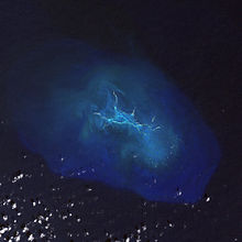
Coordinates: 25°24′54″N 170°35′24″W / 25.415°N 170.590°W Maro Reef (Hawaiian: Nalukākala - "surf that arrives in combers") is a largely submerged coral atoll located in the Northwestern Hawaiian Islands. It was discovered in 1820 by Captain Joseph Allen of the ship Maro, after whose ship the reef was named. With a total area of 747 square miles (1,935 km2), it is the largest coral reef in the Northwestern Hawaiian Islands. It contains 37 species of stony coral.
Unlike most atolls, the coral extends out from the center like spokes on a wheel. Located about 850 miles (740 nmi; 1,370 km) northwest of Honolulu, Hawaii, Maro Reef contains about 1 acre (4,000 m2) of dry land which itself can be submerged depending on the tides. Some scientists believe that it "may be on the verge of drowning" because the reefs are detached and are vulnerable to strong storm waves.[1]
References
- Maro Reef Northwestern Hawaiian Islands Coral Reef Ecosystem Reserve
- Quick Facts on Maro Reef from the PBS Ocean Adventures site
Links to related articles Northwestern Hawaiian Islands  State of Hawaii
Honolulu (capital) Topics Geography · Government · Delegations · History · Islands · Music · Language · People · Visitor Attractions
Society Main Islands Northwestern
IslandsFrench Frigate Shoals · Gardner · Kure · Laysan · Lisianski · Maro Reef · Necker · Nihoa · Pearl and Hermes
Communities Counties
Coordinates: 25°25′N 170°35′W / 25.417°N 170.583°WHawaiian volcanism topics (List) Windward
IslesLeeward
IslesNihoa · Necker Island · French Frigate Shoals · Gardner Pinnacles · Maro Reef · Laysan · Lisianski Island · Pearl and Hermes Atoll · Midway Atoll · Kure AtollEmperor
SeamountsTopics Hawaiian – Emperor seamount chain · Evolution of Hawaiian volcanoes · Hawaiian eruption · ʻAʻā (lava) · Pāhoehoe (lava) · Pele's hair · Limu o Pele · Pele's tears · Lava fountain · Hawaiian Volcano Observatory · Hawaii Volcanoes National Park · Haleakala National Park · 1955 Hawaiian submarine eruptionCategories:- Northwestern Hawaiian Islands
- Coral reefs of the United States
- Hawaii geography stubs
Wikimedia Foundation. 2010.


