- Kahului, Hawaii
Infobox Settlement
official_name = Kahului, Hawaii
other_name =
native_name =
nickname =
settlement_type = CDP
motto =
imagesize =
image_caption =
flag_size =
image_
seal_size =
image_shield =
shield_size =
image_blank_emblem =
blank_emblem_type =
blank_emblem_size =
imagesize =
image_caption =
flag_size =
image_
seal_size =
image_shield =
shield_size =
image_blank_emblem =
blank_emblem_type =
blank_emblem_size =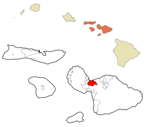
mapsize =
map_caption = Location in Maui County and the state ofHawaii
mapsize1 =
map_caption1 =
image_dot_
dot_mapsize =
dot_map_caption =
dot_x =
dot_y =
pushpin_
pushpin_label_position =
pushpin_map_caption =
pushpin_mapsize =
subdivision_type = Country
subdivision_name =United States
subdivision_type1 = State
subdivision_name1 =Hawaii
subdivision_type2 = County
subdivision_name2 = Maui
subdivision_type3 =
subdivision_name3 =
subdivision_type4 =
subdivision_name4 =
government_footnotes =
government_type =
leader_title =
leader_name =
leader_title1 =
leader_name1 =
leader_title2 =
leader_name2 =
leader_title3 =
leader_name3 =
leader_title4 =
leader_name4 =
established_title =
established_date =
established_title2 =
established_date2 =
established_title3 =
established_date3 =
area_magnitude =
unit_pref = Imperial
area_footnotes =
area_total_km2 = 42.3
area_land_km2 = 39.3
area_water_km2 = 3.0
area_total_sq_mi = 16.3
area_land_sq_mi = 15.2
area_water_sq_mi = 1.2
area_water_percent =
area_urban_km2 =
area_urban_sq_mi =
area_metro_km2 =
area_metro_sq_mi =
area_blank1_title =
area_blank1_km2 =
area_blank1_sq_mi =
population_as_of = 2000
population_footnotes =
population_note =
population_total = 20146
population_density_km2 = 513.0
population_density_sq_mi = 1328.7
population_metro =
population_density_metro_km2 =
population_density_metro_sq_mi =
population_urban =
population_density_urban_km2 =
population_density_urban_sq_mi =
population_blank1_title =
population_blank1 =
population_density_blank1_km2 =
population_density_blank1_sq_mi =
timezone = Hawaii-Aleutian
utc_offset = -10
timezone_DST =
utc_offset_DST =
latd = 20
latm = 52
lats = 54
latNS = N
longd = 156
longm = 28
longs = 3
longEW = W
elevation_footnotes =
elevation_m = 0
elevation_ft = 0
postal_code_type =ZIP code s
postal_code = 96732-96733
area_code = 808
blank_name = FIPS code
blank_info = 15-22700
blank1_name = GNIS feature ID
blank1_info = 0359843
website =
footnotes =Kahului is the largest town on the Hawaiian island of
Maui and is located along the north shore of central Maui. Kahului hosts Maui's main airport (Kahului Airport ), deep-draft harbor, light industrial areas, and commercial shopping centers. It is acensus-designated place (CDP) within Maui County, Hawaiokinai with a total population (as of the 2000 Census) of 20,146 persons.Kahului is the retail center for Maui residents and there are several malls and major stores (including department stores in the Queen Kaahumanu Center); other significant groupings of stores are in Lāhainā such as the Lahina Cannery Mall, the Happy Valley area of
Wailuku , Maui Market Place and Maui Mall, which are both also located in Kahului, and the Shops of Wailea in Kihei. Retailing changed greatly with the arrival of big-box retailers from the U.S. Mainland, includingWal-Mart andHome Depot .Kahului is not generally considered a tourist destination, but does feature the Alexander and Baldwin Sugar Museum, Kanaha Pond State Wildlife Sanctuary, Kanaha Beach County Park, and the Maui Arts and Cultural Center.
Geography and Climate
Kahului is located at 20°52'54" North, 156°28'3" West (20.881756, -156.467446)GR|1.
According to the
United States Census Bureau , the CDP has a total area of 16.3square mile s (42.3km² ), of which, 15.2 square miles (39.3 km²) of it is land and 1.2 square miles (3.0 km²) of it is water. The total area is 7.16% water.Kahului is directly adjacent to Wailuku located on the west side of town.
Demographics
As of the 2000 Census, there were 20,146 people, 5,880 households, and 4,421 families residing in the CDP. The
population density was 1,328.7 people per square mile (513.1/km²). There were 6,079 housing units at an average density of 400.9/sq mi (154.8/km²). The racial makeup of the CDP was 10.06% White, 0.24% Black or African American, 0.27% Native American, 53.62% Asian, 9.91% Pacific Islander, 1.47% from other races, and 24.42% from two or more races. 8.75% of the population were Hispanic or Latino of any race.There are 5,880 households out of which 34.9% had children under the age of 18 living with them, 51.9% were married couples living together, 16.6% had a female householder with no husband present, and 24.8% are non-families. 20.3% of all households were made up of individuals and 11.9% had someone living alone who was 65 years of age or older. The average household size was 3.29 and the average family size is 3.76.
In the CDP the population wes spread out with 25.8% under the age of 18, 9.2% from 18 to 24, 27.6% from 25 to 44, 20.7% from 45 to 64, and 16.7% who were 65 years of age or older. The median age was 36 years. For every 100 females there were 97.3 males. For every 100 females age 18 and over, there were 95.8 males.
The median income for a household in the CDP was $46,656, and the median income for a family was $52,610. Males had a median income of $30,659 versus $26,282 for females. The
per capita income for the CDP was $18,049. 11.8% of the population and 9.7% of families were below thepoverty line . Out of the total population, 14.8% of those under the age of 18 and 11.6% of those 65 and older were living below the poverty line.Education
Schools in Kahului include
Maui High School .Points of interest
* [http://www.mauiarts.org Maui Arts and Cultural Center]
*Maui Nui Botanical Gardens
* [http://kahului-travel.com Travel information]References
External links
Wikimedia Foundation. 2010.