- Kīlauea
-
For the town of Kilauea on Kauai, see Kilauea, Hawaii.
Kīlauea 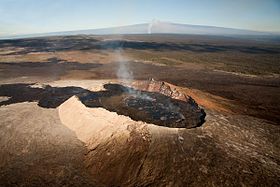
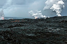
The Pu'u O'o cone, a subsidiary volcano of Kilauea. An ash column in the background rises from the peak of Kilauea. The volcano behind the ash column is Mauna Loa, which is separate from Kilauea.Elevation 4,190 ft (1,277 m) [1] Location Location Hawaiʻi, USA Range Hawaiian Islands Coordinates 19°24′26″N 155°17′00″W / 19.40722°N 155.2833333°WCoordinates: 19°24′26″N 155°17′00″W / 19.40722°N 155.2833333°W Geology Type Shield volcano Age of rock 23000 yrs (oldest dated samples)[1] Volcanic arc/belt Hawaiian-Emperor seamount chain Last eruption January 3, 1983–present Kīlauea[2] (
 /kiːlaʊˈeɪ.ə/; Hawaiian: [ˈkiːlɔuˈwɛjə]) is a volcano in the Hawaiian Islands, and one of five shield volcanoes that together form the island of Hawaiʻi. Kīlauea means "spewing" or "much spreading" in the Hawaiian language, referring to its frequent outpouring of lava. The Puʻu ʻŌʻō cone has been continuously erupting in the eastern rift-zone since 1983, making it the longest rift-zone eruption of the last 200 years. Thirty-five eruptions have taken place since 1952, not including the current episode. Lava less than 1000 years old covers 90% of Kīlauea,[3] and the volume of erupted material is large enough to pave a road around the world three times.
Kīlauea is one of the most active volcanoes on the planet[4] and an invaluable resource for volcanologists who are able to study it up close due to its exclusively non-violent effusive activity. Since 2008, rising emissions of sulphur dioxide from the Halemaʻumaʻu crater at Kīlauea's summit have led to increased levels of volcanic smog and air quality concerns. Located within Hawaiʻi Volcanoes National Park, Kīlauea is visited by millions of tourists each year, making it the most visited attraction in Hawaii and the most visited volcano in the world. Despite its relative safety for researchers and visitors alike,[5] Kīlauea is regarded by the USGS as the most dangerous volcano in the U.S.[6] In 2010 and early 2011, lava destroyed several houses in the Kalapana area.[7] According to the United States Geological Survey, the Volcanic-Alert Level for Kīlauea as of June 2011 is "Watch".[8] Since April 2011, Kīlauea surface volcanic activity remains confined inside or near two vents: one in the summit caldera, inside Halemaʻumaʻu, and the other on the east rift zone at Pu'u 'Ō'ō. [9] [10]
In the Hawaiian religion, Kīlauea is home to Pele, the goddess of volcanoes.
Contents
Description
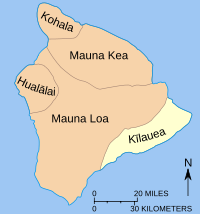 The five volcanoes that form the island of Hawaiʻi
The island of Hawaiʻi is built from five separate shield volcanoes that erupted somewhat sequentially, one overlapping the other. Listed from oldest to youngest, these are:
- Kohala (extinct);
- Mauna Kea (dormant);
- Hualālai (dormant);
- Mauna Loa (active, partly within Hawaiʻi Volcanoes National Park); and
- Kīlauea (very active; part of Hawaiʻi Volcanoes National Park).
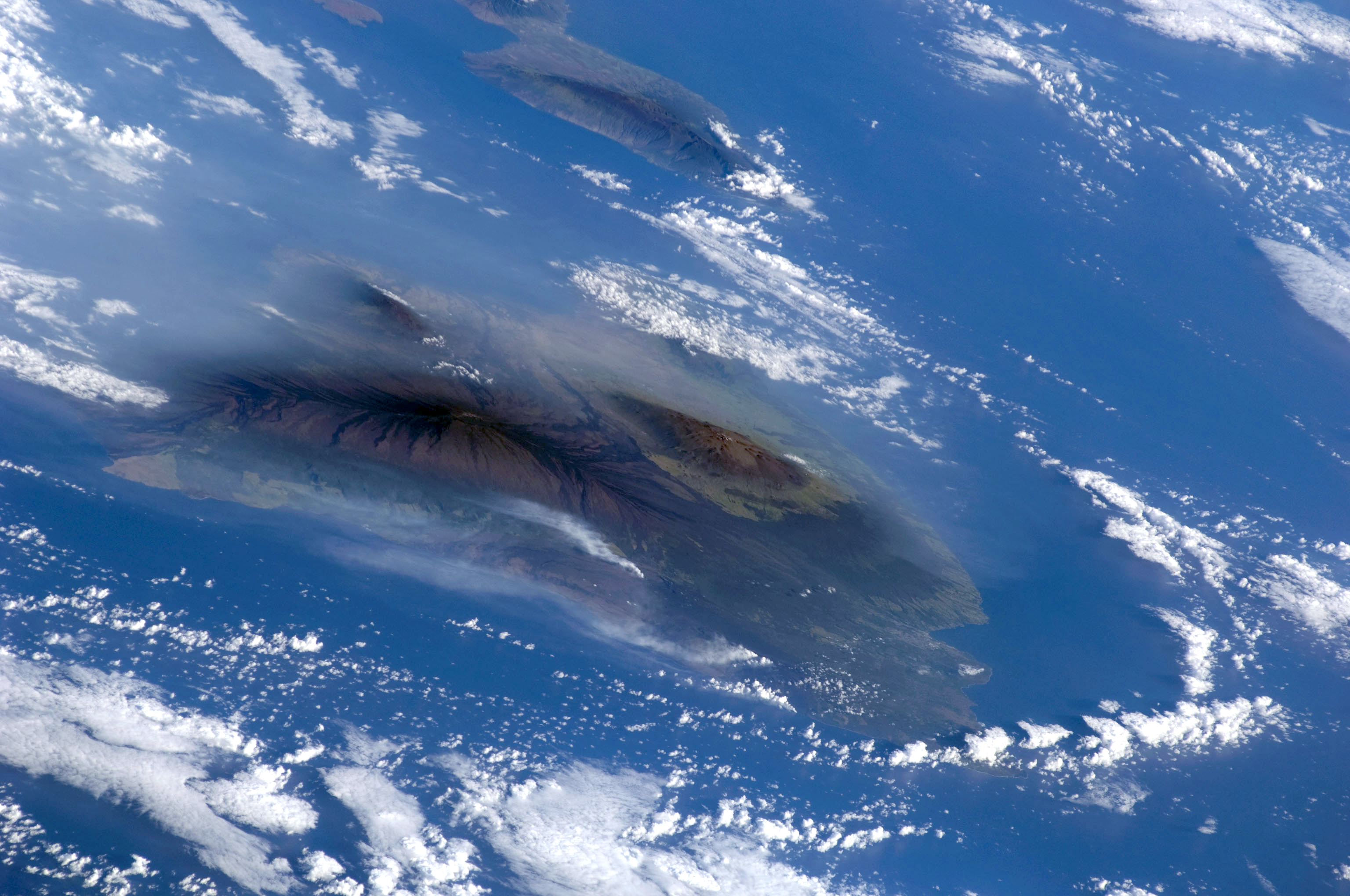
Kīlauea lies against the southeast flank of the much larger Mauna Loa volcano. Mauna Loa's massive size and elevation (13,677 feet or 4,169 m) is a stark contrast to Kīlauea, which rises only 4,091 feet (1,247 m) above sea level, and thus from the summit caldera appears as a broad shelf of uplands well beneath the long profile of occasionally snow-capped Mauna Loa, 15 miles (24 km) distant. Kīlauea is a very low, flat shield volcano — vastly different in profile from the high, sharply sloping peaks of stratovolcanoes like Mt. Fuji, Mount Hood, and Mount St. Helens.
Approaches
From Hilo, the Hawaii Belt Road, Route 11, heads south to Keaʻau, then turns westward to begin the climb to the Kīlauea caldera. For some 20 miles (32 km) the road runs relatively straight, making a very gradual 4,000-foot (1,200 m) ascent. However, most of this climb is actually on the heavily vegetated, cloud forest flank of Mauna Loa. The crossing onto lava flows issued from Kīlauea is not until about 1-mile (1.6 km) west of Glenwood, 18 miles (29 km) from Hilo. The verdant, forested Mauna Loa flows are several thousand years old, whereas the lightly vegetated Kīlauea flows are only 350 to 500 years old.
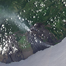 Volcanic activity at Kīlauea.
Driving south from Kailua-Kona on the west coast of Hawaiʻi, Kīlauea is 98 miles (158 km) distant along the Hawaii Belt Road, which passes through Kaʻū, the southernmost district of the island. After passing around the southern end of Mauna Loa's lengthy lower flank, the highway then turns northeast towards Kīlauea. The route through Kaʻū is different from the verdant forests seen when coming from Hilo: The route from the south approaches Kīlauea through the Kaʻū Desert, on the volcano's leeward slope. Kīlauea's height of 4,000 feet (1,200 m) is sufficient to force most of the moisture out of the impinging northeasterly trade winds, leaving much of Kaʻū in the rain shadow of the "low" mountain, creating a desert effect. The desert effect is also produced by the acid rain resulting from sulfur dioxide emitted by the volcano. This area is also the very active southwest rift zone of Kīlauea, a prolific ash producer. Winds redistribute the ash, causing dust storms and dunes barren of most vegetation.
As from the Hilo side, the long gradual climb from near sea level to the summit is actually all on the flank of Mauna Loa. Not until the Sulfur Bank scarp (the northwestern edge of Kīlauea Caldera), near the intersection of Crater Rim Drive in Hawaiʻi Volcanoes National Park, does the road cross over onto Kīlauea. From near Punaluʻu at the coast to the caldera at the summit, the highway parallels the line of contact between the two volcanoes — always less than 1-mile (1.6 km) southeast of that line.
Hawaiʻi Volcanoes National Park
Hawaiʻi Volcanoes National Park encompasses a portion of Kīlauea, and the Kīlauea Visitor Center is located near the margin of the summit caldera, overlooking a large pit crater called Halema`uma`u. The roughly circular caldera measures 3x5 km (or 6x6 km, including the outermost ring faults). The Visitor Center features exhibits about volcano, the plants and animals in the park, and the island's cultural history.
Activity
The volcano erupts frequently, with written records recording historical eruptions as early as 1820. In an earlier episode around 1790, an eruption killed a party of warriors and their families.[11] These soldiers were part of the army controlled by Keōua Kuahuʻula, the last chief on the island to resist Kamehameha I. In 1825, Admiral Lord Byron, cousin of the famous poet, visited the volcano.[12] His campsite, still known as "Byron's Ledge" is located at coordinates 19°24′54″N 155°15′23″W / 19.415°N 155.25639°W.
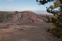 Kīlauea Iki, a subsidiary cone of Kīlauea
While Kīlauea is currently known for its largely non-explosive eruptions, it has had large explosive eruptions in the past.[13] The most recent of such explosive eruptions occurred in 1924, when magma interacted with groundwater as the long-standing lava lake in Halemaʻumaʻu Crater drained. Eruption columns are inferred to have risen at least as high as 9 km (5.6 mi) and possibly up to 15–20 km (9–12 miles)—much higher than the cruising altitude of airliners. One of the most spectacular episodes of Kīlauea lava fountaining occurred in 1959 during the Kīlauea Iki eruption. Lava sprayed nearly 580 meters (1900 ft) high. Eruptions from Kīlauea also are known for creating vog (volcanic smog), which usually affects parts of Hawaii, but can extend over many areas of the Hawaiian Islands whenever winds come out of the south or southeast.
Eruptions at Kīlauea occur primarily either from the summit caldera or along either of the East and Southwest rift zones that extend from the caldera and run approximately parallel to the coastline. In recent decades, eruptions have been continuous, with many of the lava flows reaching to the Pacific Ocean shore. About 90% of the surface of Kīlauea is lava flows less than 1,100 years old; 70% of the surface is younger than 600 years. There were 45 eruptions of Kīlauea in the 20th century.
Mauna Ulu eruption (1969–74)
The Mauna Ulu eruption of Kīlauea began on May 24, 1969, and ended on July 22, 1974. At the time, Mauna Ulu was the longest flank eruption of any Hawaiian volcano in recorded history. The eruption created a new vent, covered massive amounts of land with lava, and added new land to the island. The eruption first started as a fissure between two pit craters, ʻĀloʻi and ʻAlae, where the Mauna Ulu shield would eventually form. Both pāhoehoe and ʻaʻā lava erupted from the volcano. Early on, fountains of lava burst out as much as 540 meters (1772 ft) high. In early 1973, an earthquake occurred that caused Kīlauea to stop erupting near the original Mauna Ulu site and instead erupt near the craters Pauahi and Hiʻiaka. However, the eruption site soon returned to normal.
Summit crater explosion (2008)
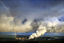
 Steam plume as Kīlauea red lava enters the ocean at three Waikupanaha and one Ki lava ocean entries. Some surface lava is seen too. The image was taken 04/16/08.For more details on this topic, see Halema`uma`u crater.
In the early morning of March 19, 2008, Halemaʻumaʻu experienced its first explosive event since 1924 and the first eruption in the Kīlauea caldera since September 1982. A steam vent that had recently opened near the overlook area exploded, generating a magnitude 3.7 earthquake, and scattering rocks over a 75-acre (300,000 m2) area. A small amount of ash was also reported at a nearby community. The explosion debris covered part of Crater Rim Drive and damaged Halemaʻumaʻu overlook. The explosion did not release any lava, which suggests to scientists that it was driven by hydrothermal or gas sources.[14]
This explosion event followed increased sulfur dioxide gas levels from the Halemaʻumaʻu crater. The dangerous increase of sulfur dioxide gas has prompted closures of Crater Rim Drive between Kīlauea Military Camp south/southeast to Chain of Craters Road, Crater Rim Trail from Kīlauea Military Camp southsoutheast to Chain of Craters Road, and all trails leading to Halemaʻumaʻu crater, including those from Byron Ledge, ʻIliahi (Sandalwood) Trail, and Kaʻū Desert Trail.[15]
Early in the morning of March 24, 2008, the white gas ejection changed to brown-gray ash, and lava particles were thrown from the vent, forming Pele's hair, Pele's tears, and 4-inch (100 mm) lava spatters around the vent. This is the first time fresh lava has been erupted in the crater since 1982.
Vent eruption and lava flows
1983-2011
Main article: Puʻu ʻŌʻō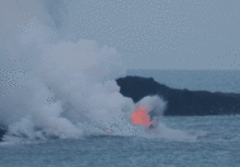 Lava explodes as it hits ocean waves
The current Kīlauea eruption began on January 3, 1983, along the East rift zone at the Pu'u 'Ō'ō vent, where vigorous fountaining built up Puʻu ʻŌʻō cone and sent lava flows downslope. In 1986, activity shifted downrift to a new vent, named Kupaianaha ("mysterious" or "astonishing" in Hawaiian), where it took on a more effusive character. Kupaianaha built into a low, broad shield rather than a cone, and tube-fed lava flows extended 11 to 12 km to the sea. In 1992, the eruption moved back to Puʻu ʻŌʻō, but continued in the same manner, covering nearly all of the 1983-86 lava flows and large areas of coastline.[16] This eruption has covered over 117 km² of land on the southern flank of Kīlauea and has built out into the sea 2 km² (230 hectares) of new land. Since 1983 more than 2.7 km³ of lava has been erupted, making the 1983-to-present eruption the largest historically known for Kīlauea. 189 structures have been destroyed.
Kamoamoa Fissure Eruption
At 1:42 p.m. on March 5, 2011, Puʻu ʻŌʻō began to rapidly deflate followed 18 minutes later by Kīlauea's summit. As magma began to drain from both, harmonic tremors substantially increased along the east rift zone. As the magma continued to drain away, Puʻu ʻŌʻō suffered several collapses as its crater floor continued to subside. At 5:15 p.m. a new eruption was observed to have begun from a fissure located between Napau Crater and Puʻu ʻŌʻō. [17] At the same time, the lava stream to the coastal flows turned sluggish, and by March 7, all activity at Kalapana had stopped.[18] The new eruption was given the name of the 'Kamoamoa Fissure Eruption' by volcanologists, and a National Park ranger stated that the volume of lava being produced by the vents was estimated to be five times that of the previous eruption on the East Rift, with the new vents generating about 2.5 million cubic meters of molten rock a day. About 120 acres were said to have been covered with lava by March 8, all within the National Park in a remote area. [19]
Property damage
Lava flows in 1987 buried much of the Royal Gardens subdivision, which was near the boundary of Hawaii Volcanoes National Park. The 1990 lava flows were notable for their destruction; the towns of Kalapana and Kaimū were totally destroyed, as were Kaimū Bay, Kalapana black sand beach, and a large section of Route 130, which now abruptly dead-ends at the lava flow.
Lava from Kīlauea destroyed three abandoned houses in the week of February 25, 2008, in a nearly deserted neighborhood.[20] On the night of March 5, 2008, lava from the flows again reached the ocean off the Puna coast, creating a spectacular show of light and color. Hawaiʻi County Civil Defense officials set up a viewing center nearby for the public to observe the phenomenon; however, the site was covered with lava July 17, 2010, by a flow that was heading east towards houses near the Kalapana Gardens subdivision built on the 1990 lava flows, with one home at that time being evacuated as a precaution.[21] The home was destroyed by lava July 25; it was reportedly the first occupied home to be claimed by the volcano in a decade, although 17 abandoned "structures" in the Royal Gardens subdivision had been overrun by lava in 2008-09. Lava also reached the ocean and again entered the water.[22]
On November 27, 2010, another home near Kalapana Gardens was destroyed as a result of a slow-moving Kilauea lava flow. The house had already been evacuated. The relocated public viewing area was closed as a precaution. Other lava flows were reported in the region but none directly threatened the remaining homes in the subdivision at that time. Lava continued to flow into the water at the Puhi o Kalaikini ocean entry.[7]
January 17, 2011, saw another Kalapana area home taken by the lava. The homeowner, who had worked for years to replant the three-acre lot that the home was built on, was quoted as saying "We'll probably be back to start over." [23][24]
Pele
For Native Hawaiians, Kīlauea is considered the "body" of Pele, the volcano goddess of ancient Hawaiian legend.[25] Several lava formations are named after her, including Pele's tears (small droplets of lava that cool in the air and retain their teardrop shapes) and Pele's hair (thin, brittle strands of volcanic glass that often form during the explosions that accompany a lava flow as it enters the ocean).[26]
In Hawaiian mythology, Kīlauea is where most of the conflict between Pele and the rain god Kamapuaʻa took place. Halemaʻumaʻu, "House of the ʻamaʻumaʻu fern", derives its name from the final struggle between the two gods: since it was the favorite residence of Pele, Kamapuaʻa, hard-pressed by Pele's ability to make lava spout from the ground at will, covered it with the fronds of the fern. Choking from the smoke which could not escape anymore, Pele emerged. Realizing that each could threaten the other with destruction, the gods had to call their fight a draw and divided the island between them: Kamapuaʻa got the windward northeastern side, and Pele got the drier Kona (or leeward) side. The rusty singed appearance of the young fronds of the ʻamaʻumaʻu was said to be a product of the legendary struggle.
References
- ^ a b "Introduction to Kilauea Volcano". Hawaii Volcano Observatory. USGS. http://hvo.wr.usgs.gov/kilauea/. Retrieved 2011-01-04.
- ^ Mary Kawena Pukui, Samuel Hoyt Elbert and Esther T. Mookini (2004). "lookup of Kīlauea". in Place Names of Hawai'i. Ulukau, the Hawaiian Electronic Library, University of Hawaii Press. http://wehewehe.org/gsdl2.5/cgi-bin/hdict?j=pp&l=en&q=K%C4%ABlauea&d=D48382.
- ^ Oracle ThinkQuest Library (2000). "Anger of Pele: Interesting Volcano Facts". Natural Disasters of Hawaii. Oracle ThinkQuest. http://library.thinkquest.org/J003007/Disasters2/volcano/interesting/interesting.htm. Retrieved 2010-08-07. Bibliography
- ^ Juvik, Sonia P.; James O. Juvik, Thomas R. Paradise (1998). Atlas of Hawaii. University of Hawaii Press. p. 45. ISBN 978-0824821258.
- ^ UXL Encyclopedia of Weather and Natural Disasters. (2008) "Volcano". Volume 4. pp. 587-615. "Kilauea also erupts nonexplosively, giving scientists an opportunity to make careful studies of its behavior in relative safety. The National Park Service provides a viewing area for tourists to observe Kilauea's activity from a safe distance, earning it the nickname of the "drive-in volcano."
- ^ Roach, John (2006-01-20). "18 Most Dangerous U.S. Volcanoes Include Erupting Alaska Peak". National Geographic News. http://news.nationalgeographic.com/news/2006/01/0120_060120_volcanoes.html. Retrieved 2010-08-21. "The overview ranks the United States' 169 volcanoes according to their threat levels and assesses the monitoring activity at each."
- ^ a b "Lava destroys house at Kalapana Gardens". Honolulu Star-Advertiser. November 27, 2010. http://www.staradvertiser.com/news/breaking/110929539.html. Retrieved November 28, 2010.
- ^ "Current Alerts for U.S. Volcanoes". USGS. http://volcanoes.usgs.gov/activity/status.php. A Watch status is used to designate escalating unrest or a minor eruption underway that poses limited hazards.
- ^ http://hawaiianlavadaily.blogspot.com/
- ^ http://volcanoes.usgs.gov/hvo/activity/kilaueastatus.php
- ^ Swanson, DA; Rausch, J (2008). Human Footprints in Relation to the 1790 Eruption of Kīlauea. 89. Eos Trans. AGU, Fall Meeting 2008, abstract #V11B-2022.
- ^ Bloxam, Rowland (1920). "Visit of H.M.S. Blonde to Hawaii in 1825". All about Hawaii: Thrum's Hawaiian Annual and Standard Guide. Honolulu: Thomas G. Thrum. pp. 66–82. http://books.google.com/books?id=4I8LAAAAIAAJ&pg=RA3-PA66.
- ^ Hawaiian Volcano Observatory (2005). "Kilauea: an explosive volcano in Hawaiʻi". USGS. http://hvo.wr.usgs.gov/hazards/explosivepast/. Retrieved 2010-08-08.
- ^ Hawaiian Volcano Observatory (2008-03-19). "Explosive eruption in Halemaʻumaʻu Crater, Kilauea Volcano, is first since 1924". USGS. http://hvo.wr.usgs.gov/pressreleases/pr03_19_08.html. Retrieved 2010-08-08.
- ^ National Park Service (2010). "Hawaiʻi Volcanoes National Park - Closed Areas and Advisories". National Park Service. http://www.nps.gov/havo/closed_areas.htm. Retrieved 2010-08-08.
- ^ Hawaiian Volcano Observatory (2010). "Surges Interspersed Among Steady-state Activity". USGS. http://hvo.wr.usgs.gov/kilauea/update/archive/update980417.html. Retrieved 2010-08-08.
- ^ http://hvo.wr.usgs.gov/pressreleases/pr03_05_11.html
- ^ "New eruption spews 2.5 million cubic meters of lava per day". 2011-03-08. http://www.staradvertiser.com/news/breaking/Each_day_of_new_eruption_brings_new_developments.html#. Retrieved 2011-03-09.
- ^ "Latest Kilauea eruption gets a name". 2011-03-08. http://www.staradvertiser.com/news/breaking/117630253.html. Retrieved 2011-03-09.
- ^ "Homeowner: "It's Very Easy to Outrun Lava"". Jamaica News-Bulletin. February 29, 2008. http://www.jamaicanewsbulletin.com/component/content/article/55-international-news/81--homeowner-its-very-easy-to-outrun-lava.html/.
- ^ Stewart, Colin M. (2010-07-20). "Lava river threatens homes". Hawaii Tribune-Herald. http://www.hawaiitribune-herald.com/articles/2010/07/20/local_news/local01.txt. Retrieved 2010-08-08.
- ^ Hirji, Zahra (2010-07-28). "Kilauea Lava Flows Claim 1 House, 2 More Threatened". Discovery News. http://news.discovery.com/earth/kilauea-lava-flows-claim-1-house-2-more-threatened.html. Retrieved 2010-08-08.
- ^ "Lava claims Kalapana oasis". 2011-01-19. http://www.hawaiitribune-herald.com/articles/2011/01/19/local_news/local01.txt. Retrieved 2011-01-19.
- ^ "Third home in Kalapana Gardens area lost to lava". 2011-01-18. http://hawaiianlavadaily.blogspot.com/2011/01/third-home-in-kalapana-gardens-area.html. Retrieved 2011-01-18.
- ^ Bernbaum, Edwin (Nov., 2006). "Sacred Mountains: Themes and Teachings". Mountain Research and Development (International Mountain Society) 26 (4, Religion and Sacredness in Mountains: A Historical Perspective): 306. doi:10.1659/0276-4741(2006)26[304:SMTAT]2.0.CO;2. http://www.bioone.org/doi/abs/10.1659/0276-4741%282006%2926%5B304:SMTAT%5D2.0.CO%3B2.
- ^ Bryan, William Alanson (1915). Natural History of Hawaii. Hawaiian Gazette Company. pp. 88–91. ISBN 1444678205. http://books.google.com/books?id=SfkJAAAAMAAJ.
Further reading
- United States Geological Survey (2003). Geologic map of the summit region of Kīlauea Volcano, Hawai (Map). 1:24,000. Geologic Investigations Series I-2759. http://pubs.usgs.gov/imap/i2759/. Retrieved 2010-08-09.
- United States Geological Survey (2006). Geologic map of the middle east rift geothermal subzone of Kīlauea Volcano, Hawaii (Map). 1:24,000. Geologic Investigations Series I-2614 (1.0 ed.). ISBN 1411306597. http://permanent.access.gpo.gov/LPS77789/2614map_508.pdf. Retrieved 2010-08-09.
External links
- Hawaiʻi Volcanoes National Park website
- Hawaiian Volcano Observatory's Kīlauea website
- Hawaiian Volcano Observatory's Kīlauea eruption update website (updated daily)
- "Kilauea". Global Volcanism Program, Smithsonian Institution. http://www.volcano.si.edu/world/volcano.cfm?vnum=1302-01-.
- Live webcam of Halema`uma`u Crater
- Live webcam of Puu OO vent
- Littoral lava fountains at ocean entry 18 and 21 Aug 2008
- Kilauea Visitor Center
- Hiking the Kilauea Iki
- Video footage of the March 2011 Kamoamoa Fissure Eruption and the collapse of Puʻu ʻŌʻō crater
Hawaiian volcanism topics (List) Windward
Isles
Leeward
IslesEmperor
SeamountsTopics Hawaiian – Emperor seamount chain · Evolution of Hawaiian volcanoes · Hawaiian eruption · ʻAʻā (lava) · Pāhoehoe (lava) · Pele's hair · Limu o Pele · Pele's tears · Lava fountain · Hawaiian Volcano Observatory · Hawaii Volcanoes National Park · Haleakala National Park · 1955 Hawaiian submarine eruptionNational Register of Historic Places in Hawaii Volcanoes National Park Historic districts Puna-Ka'u Historic District
NRHP properties 1790 Footprints | Ainahou Ranch | Ainapo Trail | Kilauea Crater | Old Volcano House No. 42 | Whitney Seismograph Vault No. 29 | Wilkes Campsite
Categories:- Active volcanoes
- Hotspot volcanoes
- Mountains of Hawaii
- Shield volcanoes
- VEI-1 volcanoes
- VEI-2 volcanoes
- Volcanic calderas of Hawaii
- Volcanoes of the Island of Hawaii
- Hawaiʻi Volcanoes National Park


Wikimedia Foundation. 2010.