- Kilauea, Hawaii
Infobox Settlement
official_name = Kilauea, Hawaii
other_name =
native_name =
nickname =
settlement_type = CDP
motto =
imagesize =
image_caption =
flag_size =
image_
seal_size =
image_shield =
shield_size =
image_blank_emblem =
blank_emblem_type =
blank_emblem_size =
imagesize =
image_caption =
flag_size =
image_
seal_size =
image_shield =
shield_size =
image_blank_emblem =
blank_emblem_type =
blank_emblem_size =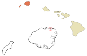
mapsize =
map_caption = Location in Kauai County and the state ofHawaii
mapsize1 =
map_caption1 =
image_dot_
dot_mapsize =
dot_map_caption =
dot_x =
dot_y =
pushpin_
pushpin_label_position =
pushpin_map_caption =
pushpin_mapsize =
subdivision_type = Country
subdivision_name =United States
subdivision_type1 = State
subdivision_name1 =Hawaii
subdivision_type2 = County
subdivision_name2 = Kauai
subdivision_type3 =
subdivision_name3 =
subdivision_type4 =
subdivision_name4 =
government_footnotes =
government_type =
leader_title =
leader_name =
leader_title1 =
leader_name1 =
leader_title2 =
leader_name2 =
leader_title3 =
leader_name3 =
leader_title4 =
leader_name4 =
established_title =
established_date =
established_title2 =
established_date2 =
established_title3 =
established_date3 =
area_magnitude =
unit_pref = Imperial
area_footnotes =
area_total_km2 = 3.9
area_land_km2 = 3.9
area_water_km2 = 0.0
area_total_sq_mi = 1.5
area_land_sq_mi = 1.5
area_water_sq_mi = 0.0
area_water_percent =
area_urban_km2 =
area_urban_sq_mi =
area_metro_km2 =
area_metro_sq_mi =
area_blank1_title =
area_blank1_km2 =
area_blank1_sq_mi =
population_as_of = 2000
population_footnotes =
population_note =
population_total = 2092
population_density_km2 = 538.6
population_density_sq_mi = 1395.0
population_metro =
population_density_metro_km2 =
population_density_metro_sq_mi =
population_urban =
population_density_urban_km2 =
population_density_urban_sq_mi =
population_blank1_title =
population_blank1 =
population_density_blank1_km2 =
population_density_blank1_sq_mi =
timezone = Hawaii-Aleutian
utc_offset = -10
timezone_DST =
utc_offset_DST =
latd = 22
latm = 12
lats = 40
latNS = N
longd = 159
longm = 24
longs = 35
longEW = W
elevation_footnotes =
elevation_m = 89
elevation_ft = 292
postal_code_type =ZIP code s
postal_code = 96722, 96754
area_code = 808
blank_name = FIPS code
blank_info = 15-36650
blank1_name = GNIS feature ID
blank1_info = 0361214
website =
footnotes = :"For information on thevolcano , see Kīlauea."Kīlauea (literally, "much spreading" in Hawaiian [Cite book | author=Pukui, Mary Kawena | authorlink= | coauthors= | title=Place Names of Hawaii | date= | publisher=University of Hawaii Press | location= | isbn=0-8248-0524-0 | pages=] ) is a
census-designated place (CDP) in Kauaokinai County, Hawaiokinai,United States . The population was 2,092 at the 2000 census.Geography
Kīlauea is located at coor dms|22|12|40|N|159|24|35|W|city (22.211103, -159.409609)GR|1.
According to the
United States Census Bureau , the CDP has a total area of 1.5square mile s (3.9km² ), of which, 1.5 square miles (3.9 km²) of it is land and 0.66% is water.Demographics
As of the
census GR|2 of 2000, there were 2,092 people, 692 households, and 519 families residing in the CDP. Thepopulation density was 1,395.0 people per square mile (538.5/km²). There were 743 housing units at an average density of 495.5/sq mi (191.2/km²). The racial makeup of the CDP was 47.80% White, 0.67% African American, 0.57% Native American, 26.58% Asian, 6.21% Pacific Islander, 1.05% from other races, and 17.11% from two or more races. Hispanic or Latino of any race were 7.12% of the population.There were 692 households out of which 43.8% had children under the age of 18 living with them, 53.2% were married couples living together, 16.0% had a female householder with no husband present, and 25.0% were non-families. 19.2% of all households were made up of individuals and 5.5% had someone living alone who was 65 years of age or older. The average household size was 3.02 and the average family size was 3.42.
In the CDP the population was spread out with 29.3% under the age of 18, 5.8% from 18 to 24, 29.4% from 25 to 44, 25.9% from 45 to 64, and 9.6% who were 65 years of age or older. The median age was 36 years. For every 100 females there were 102.7 males. For every 100 females age 18 and over, there were 96.7 males.
The median income for a household in the CDP was $41,313, and the median income for a family was $48,824. Males had a median income of $30,089 versus $24,107 for females. The
per capita income for the CDP was $19,184. About 10.1% of families and 12.4% of the population were below thepoverty line , including 16.0% of those under age 18 and 3.6% of those age 65 or over.Points of interest
* Na okinaĀina Kai Botanical Gardens
* Kīlauea LighthouseReferences
External links
Wikimedia Foundation. 2010.