- Mauna Loa
-
For other uses, see Mauna Loa (disambiguation).
Mauna Loa 
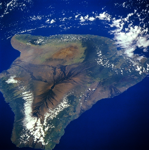
Mauna Loa is the dark volcano surrounded by clouds at the bottom of this satellite photograph of Hawai'iElevation 13,679 ft (4,169 m) [1] Prominence 7,079 ft (2,158 m) [1] Listing Ultra Location Hawaii, USA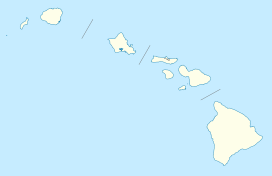
 Mauna Loa
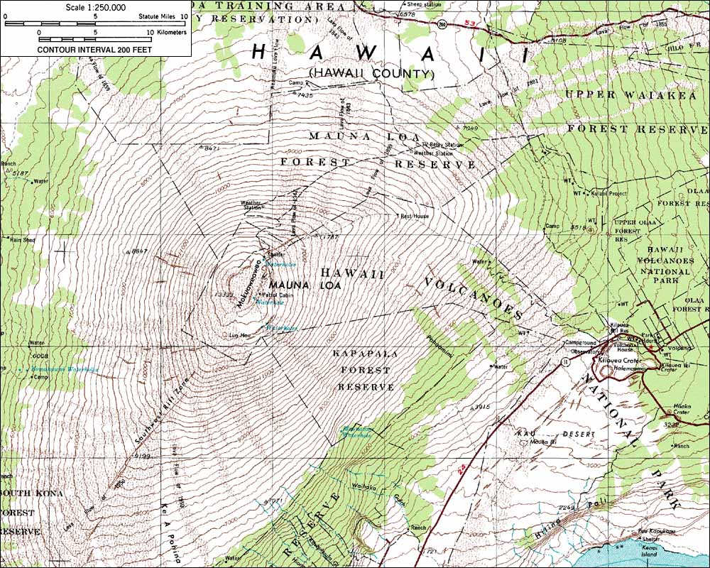
Range Hawaiian Islands Coordinates 19°28′46.3″N 155°36′09.6″W / 19.479528°N 155.602667°WCoordinates: 19°28′46.3″N 155°36′09.6″W / 19.479528°N 155.602667°W Topo map USGS Mauna Loa Geology Type Shield volcano Age of rock less than 200 thousand years Volcanic arc/belt Hawaiian-Emperor seamount chain Last eruption 1984 Climbing First ascent 1794 Easiest route Truck trail 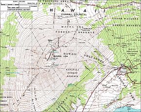 Topographical map of Mauna Loa
Mauna Loa (
 /ˌmɔːnə ˈloʊ.ə/ or /ˌmaʊnə ˈloʊ.ə/; Hawaiian: [ˈmɔunə ˈlowə]) is one of five volcanoes that form the Island of Hawaii in the U.S. state of Hawaiʻi in the Pacific Ocean, and the largest on Earth in terms of volume and area covered. It is an active shield volcano, with a volume estimated at approximately 18,000 cubic miles (75,000 km3),[2] although its peak is about 120 feet (37 m) lower than that of its neighbor, Mauna Kea. The Hawaiian name "Mauna Loa" means "Long Mountain".[3] Lava eruptions from Mauna Loa are silica-poor, and very fluid; eruptions tend to be non-explosive and the volcano has relatively shallow slopes.
Mauna Loa has probably been erupting for at least 700,000 years, and may have emerged above sea level about 400,000 years ago. The oldest-known dated rocks are not older than 200,000 years.[4] The volcano's magma comes from the Hawaii hotspot, which has been responsible for the creation of the Hawaiian island chain over tens of millions of years. The slow drift of the Pacific Plate will eventually carry Mauna Loa away from the hotspot within 500,000 to one million years from now, at which point it will become extinct.
Mauna Loa's most recent eruption occurred from March 24, 1984, through April 15, 1984. No recent eruptions of the volcano have caused fatalities, but eruptions in 1926 and 1950 destroyed villages, and the city of Hilo is partly built on lava flows from the late 19th century. In view of the hazards it poses to population centers, Mauna Loa is part of the Decade Volcanoes program, which encourages studies of the most dangerous volcanoes. Mauna Loa has been intensively monitored by the Hawaiian Volcano Observatory since 1912. Observations of the atmosphere are undertaken at the Mauna Loa Observatory, and of the Sun at the Mauna Loa Solar Observatory, both located near its summit. Hawaii Volcanoes National Park covers the summit and the southeastern flank of the volcano, including a separate volcano, Kīlauea.
Contents
Structure
 A cinder cone and surrounding flows on Mauna Loa.
Mauna Loa is the world's largest shield volcano in terms of area covered. Mauna Loa is shaped like a shield, because its lava is extremely fluid (it has low viscosity), and its slopes are not steep. Eruptions are rarely violent, and the most common form is in the Hawaiian style, which involves lava fountains feeding lava flows. Typically, at the start of an eruption, a rift up to several kilometers long opens, with lava fountains occurring along its length in a so-called "curtain of fire." After a few days, activity normally becomes concentrated at one vent.[5]
Eruptions generally occur in three regions on the mountain: at the summit and in two rift zones extending northeast and southwest of the summit. About 38% of eruptions in the last two hundred years have occurred at the summit, 31% in the northeast rift zone, and 25% in the southwest rift zone. The remaining 6% have occurred from vents to the northwest of the summit, away from the rift zones.[6] Its summit caldera is called Mokuʻāweoweo; it is 1.75 to 3 miles (3–5 km) in diameter. The caldera probably formed 1,000–1,500 years ago when a very large eruption from the northeast rift zone emptied out the shallow magma chamber beneath the summit, which then collapsed.[7]
Seismic data can reveal the locations of the magma chambers beneath the volcano which feed activity. Some types of seismic waves, known as "S-waves," cannot travel through liquid rock, so magma chambers cast 'shadows' in seismic data. Seismic shadows reveal a magma chamber about 1.75 miles (3 km) beneath the summit and smaller magma bodies beneath the rift zones.[8]
Trade winds blow from east to west across the Hawaiian islands, and the presence of Mauna Loa strongly affects the local climate. At low elevations, the eastern (windward) side of the volcano receives heavy rain, and the city of Hilo is the wettest in the United States. The rainfall supports extensive forestation. The western (leeward) side has a much drier climate. At higher elevations, the amount of precipitation decreases, and skies are very often clear. Very low temperatures mean that precipitation often occurs in the form of snow, and the summit of Mauna Loa is described as a periglacial region, where freezing and thawing play a significant role in shaping the landscape.[9]
Mokuʻāweoweo
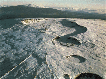
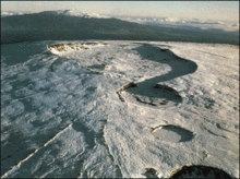 The summit covered in snow.
Mokuʻāweoweo is the summit crater (caldera) of Mauna Loa. Although a trail was developed in ancient times, Mokuaweoweo proved a difficult goal for the first outsiders who underestimated the difficulty of the journey. An American visit in 1840 turned into a trip of almost a month. Historically very active, Mokuʻāweoweo has been quiet since 1984.
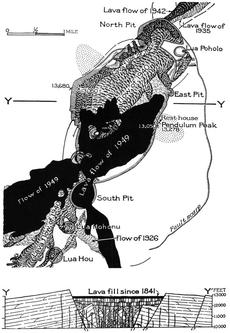
The name of the summit crater is derived from the ʻāweoweo, a red Hawaiian big-eyed fish, Priacanthus meeki, purportedly due to resemblance of the eruptive fires to the color of the fish.[10] The main oval depression is about 3 miles (4,800 m) long and 1.5 miles (2,400 m) wide. Two side craters, partially fused with the main one, are known as North Pit and South Pit. Southwest of the summit caldera are two smaller pit craters, Lua Hou (New Pit) and Lua Hohonu (Deep Pit).[11]
Mokuʻāweoweo is now part of the Hawaii Volcanoes Wilderness area, in the U.S. National Wilderness Preservation System.[12]
Geology and history
Origins
Mauna Loa began erupting between 700,000 and 1,000,000 years ago and has grown steadily since then. Like all of the Hawaiian islands, Mauna Loa has its origins in the Hawaii hotspot—a plume of magma rising from deep in the Earth's mantle. The hotspot remains in a fixed position, while the Pacific Plate drifts over it at a rate of about 4 inches (10 cm) per year. The upwelling of the hot magma creates volcanoes, and each individual volcano erupts for a few million years before the movement of the plate carries it away from the rising magma.
The hotspot has existed for at least 80 million years, and the Emperor Seamounts chain of old volcanoes stretches almost 3,600 miles (5,800 km) away from the hotspot. Currently, the hotspot feeds activity at five volcanoes: Mauna Loa, Kīlauea, and Hualālai on the Big Island, Haleakalā on Maui, and Loʻihi, a submarine volcano south of the Big Island and the youngest Hawaiian volcano. Mauna Loa is the largest of these, although Kīlauea is currently the site of the most intense volcanic activity.[13]
Prehistoric eruptions
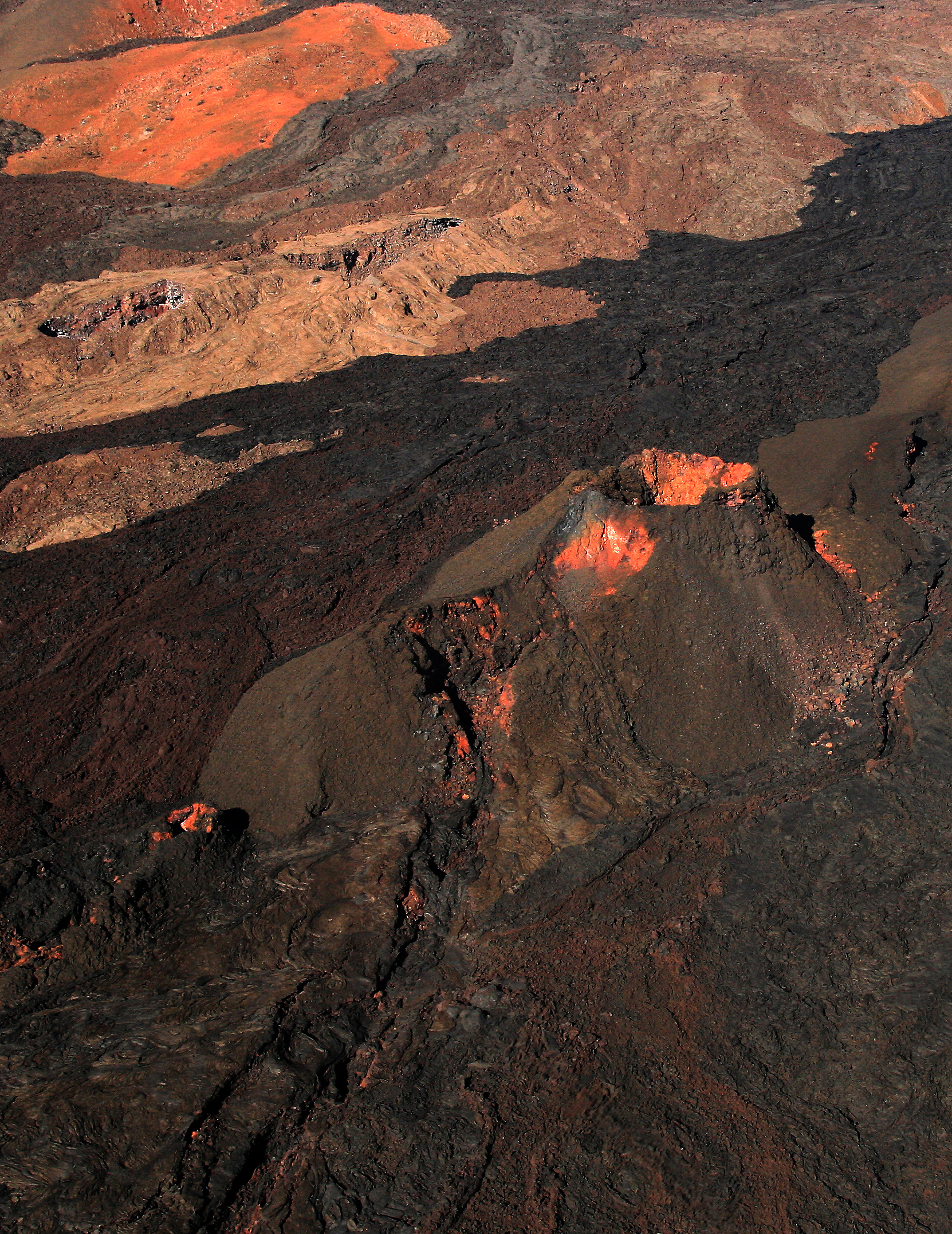
 Mauna Loa erupting in 1984
Prehistoric eruptions of Mauna Loa have been extensively analyzed by carrying out radiocarbon dating on fragments of charcoal found beneath lava flows. The mountain's prehistoric activity is probably the best known of any volcano. Studies have shown that a cycle occurs in which volcanic activity at the summit is dominant for several hundred years, after which activity shifts to the rift zones for several more centuries, and then back to the summit again. Two cycles have been clearly identified, each lasting 1,500–2,000 years. This cyclical behavior is unique to Mauna Loa among the Hawaiian volcanoes.[14]
Records show that between about 7,000 and 6,000 years ago Mauna Loa was largely inactive. The cause of this cessation in activity is not known, and no known similar hiatus has been found at other Hawaiian volcanoes except for those currently in the post-shield stage. Between 11,000 and 8,000 years ago, activity was more intense than it is today.[6] However, Mauna Loa's overall rate of growth has probably begun to slow over the last 100,000 years,[15] and the volcano may in fact be nearing the end of its tholeiitic basalt shield-building phase.[16]
Climate
Mauna Loa has a tropical highland climate with cool to cold temperatures all year long. Below is the table for the slope obsevatory , not for the peak. The highest recorded temperature was 85F (29.4C) and the lowest was 18F (-7.7C) on February 18, 2003 and February 20, 1962, respectively.[17]
Climate data for Mauna Loa slope observatory (1961-1990) Month Jan Feb Mar Apr May Jun Jul Aug Sep Oct Nov Dec Year Average high °F (°C) 49.8
(9.9)49.6
(9.8)50.2
(10.1)51.8
(11.0)53.9
(12.2)57.2
(14.0)56.4
(13.6)56.3
(13.5)55.8
(13.2)54.7
(12.6)52.6
(11.4)50.6
(10.3)53.24
(11.80)Average low °F (°C) 33.3
(0.7)32.9
(0.5)33.2
(0.7)34.6
(1.4)36.6
(2.6)39.4
(4.1)38.8
(3.8)38.9
(3.8)38.5
(3.6)37.8
(3.2)36.2
(2.3)34.3
(1.3)36.21
(2.34)Precipitation inches (mm) 2.3
(58)1.5
(38)1.7
(43)1.3
(33)1.0
(25)0.5
(13)1.1
(28)1.5
(38)1.3
(33)1.1
(28)1.7
(43)2.0
(51)17
(432)Snowfall inches (cm) 0.0
(0)1.0
(2.5)0.3
(0.8)1.3
(3.3)0.0
(0)0.0
(0)0.0
(0)0.0
(0)0.0
(0)0.0
(0)0.0
(0)1.0
(2.5)3.6
(9.1)Source: NOAA,[18] Ascents
Prehistoric
The ʻAinapō Trail was established in prehistoric times, rising from the village of Kapāpala over 11,200 feet (3,400 m) in about 35 miles (56 km). Although the more active and accessible Kīlauea caldera was the usual site to honor the fire goddess Pele, offerings and prayers were also made on Mokuʻāweoweo during its eruptions. Journeys up the trail extended over many days and required many porters. Several established camps along the way supplied water and food.[19]
John Ledyard
John Ledyard led a team to attempt an ascent on the third voyage of Captain James Cook in January 1779. They struggled to go directly up from Kealakekua Bay, but turned back after an estimated 24 miles (39 km), thinking they had about 11 miles (18 km) more to go.[20] The summit was actually only a total of 20 miles (32 km) from the coast.[21]
Archibald Menzies
Archibald Menzies led a party from the Vancouver Expedition in the first successful ascent to Mokuʻāweoweo with a written record. He also first tried a direct route from the west and turned back in February 1793. After arriving again the next year, he climbed to the summit of Hualālai, on the northwest part of the island. He then tried to cross the interior plateau to Mauna Loa, but had to turn back. He consulted King Kamehameha I and was astonished to learn he could take canoes to the south and follow the route established by Ancient Hawaiians known as the ʻAinapō Trail.[21]
On his third attempt on February 16, 1794, Menzies reached the summit and used a barometer to estimate the height as 13,634 feet (4,156 m) compared to its currently known height of 13,679 feet (4,169 m).[22] He was surprised to find heavy snow and morning temperatures of 26 °F (−3 °C). He again underestimated the length of the climb and exhausted food rations, arriving with only three coconuts left for the summit party. The sheer mass of Mauna Loa is deceptive. Slopes are generally not very steep (always less than 12°[11]) which makes it very hard to judge progress on the trail.
Others
On January 29, 1834, 40 years later, another European, David Douglas, reached the summit, also using the ʻAinapō Trail.[22]
It is sometimes reported that missionary Joseph Goodrich reached the summit around this time, but he never claimed this himself. He climbed Mauna Kea, and described the sight of Mokuʻāweoweo from Mauna Kea through a telescope.
Isidor Löwenstern successfully climbed Mauna Loa in February 1839, only the third successful climb in 60 years.[21]
Wilkes expedition
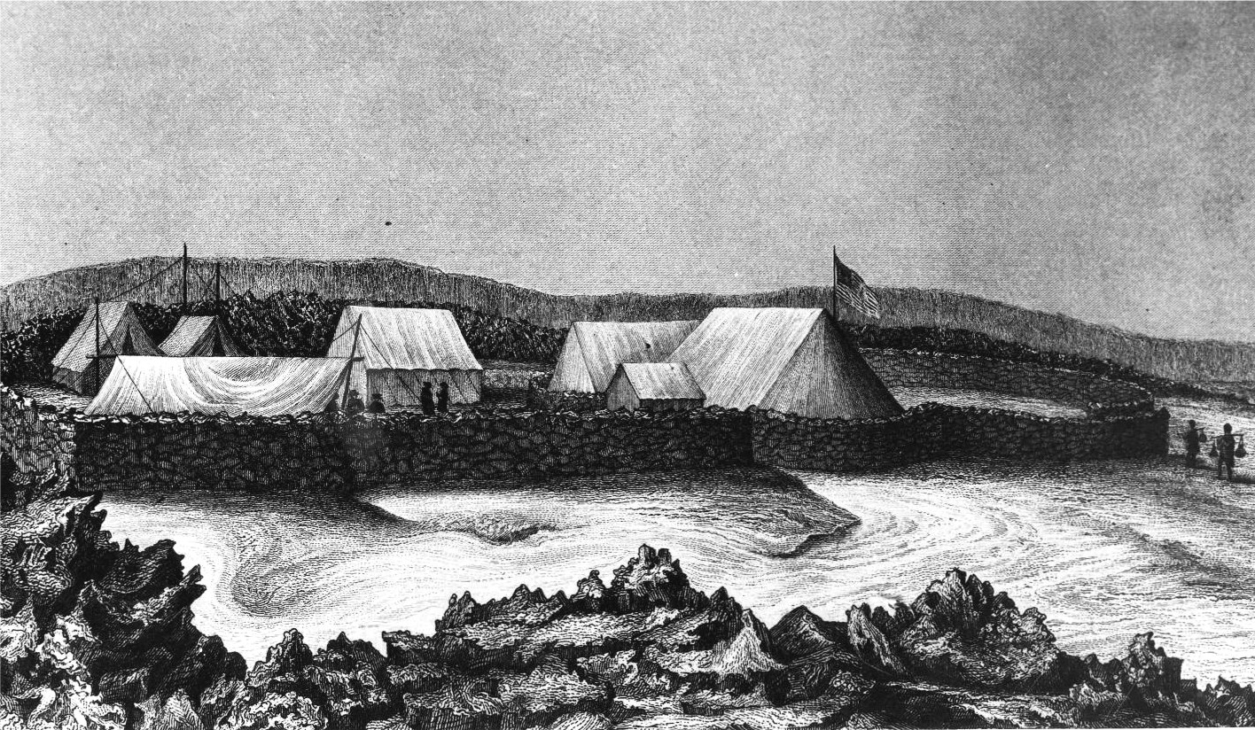
Wilkes Campsite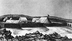 Sketch by ship's artist Alfred Thomas Agate

Nearest city: Hilo, Hawaii Coordinates: 19°27′59″N 155°34′54″W / 19.46639°N 155.58167°W Area: 4 acres (16,000 m2) Built: 1840 Architect: Charles Wilkes Architectural style: Stone shelter Governing body: National Park Service NRHP Reference#: 74000295[23] Added to NRHP: July 24, 1974 The United States Exploring Expedition led by Lieutenant Charles Wilkes was tasked with a vast survey of the Pacific Ocean starting in 1838.[24] In September 1840 they arrived in Honolulu, where repairs to the ships took longer than expected. He decided to spend the winter in Hawaii and take the opportunity to explore its volcanoes while waiting for better weather to continue the expedition. King Kamehameha III assigned American medical missionary Dr. Gerrit P. Judd to the expedition as translator.[20]
Wilkes sailed to Hilo on the island of Hawaiʻi and decided to climb Mauna Loa first, since it looked easier than Mauna Kea. On December 14 he hired about 200 porters, but after he left he realized only about half the equipment had been taken, so had to hire more Hawaiians at higher pay. When they reached Kīlauea after two days, their guide Puhano headed off to the established ʻAinapō Trail. Wilkes did not want to head back downhill so he blazed his own way through dense forest directed by a compass. The Hawaiians were offended by the waste of sacred trees, which did not help morale. At about 6,000 feet (1,800 m) elevation they established a camp called "Sunday Station" at the edge of the forest.
Two guides joined them at Sunday Station: Keaweehu, "the bird-catcher" and another whose Hawaiian name is not recorded, called "ragsdale". Although Wilkes thought he was almost to the summit, the guides knew they were less than half way up. Since there was no water at Sunday Station, porters had to be sent back ten miles (16 km) to a lava tube on ʻAinapō Trail which had a known supply. After an entire day replenishing stocks, they continued up to a second camp they called "Recruiting Station" at about 9,000 feet (2,700 m) elevation. After another full day's hike they established "Flag Station" on December 22, and by this time were on the ʻAinapō Trail. Most of the porters were sent back down to get another load.
At the Flag Station Wilkes and his eight remaining men built a circular wall of lava rocks and covered the shelter with a canvas tent. A snowstorm was in progress and several suffered from altitude sickness. That night (December 23), the snow on the canvas roof caused it to collapse. At daylight some of the group went down the trail to retrieve firewood and the gear abandoned on the trail the day before. After another day's climb, nine men reached the rim of Mokuʻāweoweo. They could not find a way down its steep sides so chose a smooth place on the rim for the camp site, at coordinates 19°27′59″N 155°34′54″W / 19.46639°N 155.58167°W. Their tent was pitched within 60 feet (18 m) of the crater's edge, secured by lava blocks.[25]
The next morning they were unable to start a fire using friction due to the thin air at that altitude, and sent for matches. By this time, the naval officers and Hawaiians could not agree on terms to continue hiring porters, so sailors and marines were ordered from the ships. Dr. Judd traveled between the summit and the Recruiting Station to tend the many who suffered from altitude sickness or had worn out their shoes on the rough rock. Christmas Day was spent building rock walls around the camp to give some protection from the high winds and blowing snow. It took another week to bring all the equipment to the summit, including a pendulum designed for measuring slight variations in gravity.[25]
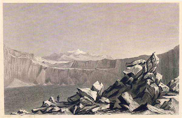
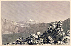 Sketch of Mokuʻāweoweo from Wilkes' journal
On December 31, 1840 the pre-fabricated pendulum house was assembled. Axes and chisels cut away the rock surface for the pendulum's base. It took another three days to adjust the clock to the point where the experiments could begin. However, the high winds made so much noise that the ticks could often not be heard, and varied the temperature to make measurements inaccurate. Grass had to be painstakingly brought from the lowest elevations for insulation to get accurate measurements.
On Monday, January 11, Wilkes hiked around the summit crater. Using an optical method, he estimated Mauna Kea was only 193 feet (59 m) higher (modern measurements are 104 feet (32 m) feet). On January 13, 1841, he had "Pendulum Peak, January 1841 U.S. Ex, Ex." cut into a rock at the site. The tents were dismantled and Hawaiians carried the gear down over the next three days, while Wilkes enjoyed a lomilomi Hawaiian massage. He continued his measurements at lower elevations and left the island on March 5. For all the effort he did not obtain any significant results, attributing gravity discrepancies to "the tides".[20]
The Wilkes expedition's camp site's ruins are the only known physical evidence in the Pacific of the U. S. Exploring Expedition.[25] The camp site was listed on the National Register of Historic Places on July 24, 1974 as site 74000295,[23] and is state historic site 10-52-5507.[26]
Today
A summit shelter was built with some of the stones from Wilkes' camp site and mortar in 1934. In 1916 Mokuʻāweoweo was included in Hawaii Volcanoes National Park, and a new trail was built directly from park headquarters at Kīlauea, an even more direct route than the one taken by Wilkes.[19] This trail, arriving at the summit from the east via Red Hill, became the preferred route due to its easier access and gentler slope. After falling into disuse, the historic ʻAinapō Trail was reopened in the 1990s. A third modern route to the summit is from the Saddle Road, up to the Mauna Loa Observatory which is located at the elevation of 11,135 feet (3,394 m) a few miles north of Mokuʻāweoweo, and the North Pit trail.[27]
Historic eruptions
 Lava flows 1926 - 1950 (from H. T. Stears and G. A. Macdonald, Hawaiian Volcano Observatory)
Although Ancient Hawaiians had witnessed eruptions for many centuries, written records exist only for eruptions that have occurred since the early 19th century. The first historical eruption occurred in 1832, and since then 32 eruptions have been documented.
The typical pattern is for an eruption to start at Mokuʻāweoweo, then move to a focal vent lower on one of the rift zones. Often, a major rift eruption is preceded by a smaller event that is limited to Mokuʻāweoweo, a year or more before the larger one. The latter occurred in 1880, 1940, and 1949, before the massive flank eruptions of 1881, 1942, and 1950. In total, these eruptions have covered over 310 square miles (800 km2) of the volcano's flanks with lava flows. Typically, eruptions have been brief but intense, with 0.06 to 0.12 cubic miles (0.25–0.5 km³) of lava erupted over a few weeks.[28]
The most prominent historic eruptions of Mauna Loa, with extensive lava flows in forest and agricultural areas, were in 1855, 1881, 1935, 1942, and 1950 on the northeast rift zone; 1887, 1907, 1916, 1919, 1926, and 1950 on the southwest rift zone; and the 1859 radial vent eruption.[28]
An eruption in 1935 that headed toward the city of Hilo led to an unusual employment of air power. Five bombers of the 23d and 72d Bombardment Squadrons of the United States Air Force dropped bombs in the path of the lava in order to divert it away from Hilo.[29][30][31] The eruption stopped six days later.[32] The first flow extended 24 kilometers (15 mi) from the vent at 2,800 meters (9,200 ft) elevation to the ocean in only three hours during the night, and a second flow before dawn cut off the escape route for people in the village of Hoʻokena.[33] The eruption eventually focused on a flow further to the south, which also reached the ocean.
On March 25, 1984 an eruption started: a small summit eruption was followed by a larger flank lava flow that threatened Hilo.[34] Fissures opened to the northwest and southeast, from the summit down to 9,500 feet (2,900 m) above sea level. Flows from this eruption headed rapidly towards Hilo again, but stopped about 2.5 miles (4.0 km) from the outskirts when the eruption ended after three weeks.[13]
As of 2009, Mauna Loa has been inactive for over 25 years, its longest quiet period in recorded history.[11][28]
Current activity
In 2002 seismic activity, which had been low, increased, and inflation suddenly started, and the caldera walls started to move apart at 2 inches (5 cm) per year. This is thought to indicate that magma is filling a reservoir about 3.1 miles (5.0 km) beneath the summit. The inflation has been intermittent, sometimes slowing, and sometimes stopping for several weeks. Thus far, though, it has always restarted, and this is likely to indicate an increased probability of an eruption in the next few years.
In July 2004 a swarm of deep earthquakes began, and continued until the end of the year. Earthquakes were detected at a rate of one per day for the first three weeks, increasing steadily over subsequent months to 15 or so per day by the end of the year. The swarm ended in December 2004, and earthquake levels have been only moderately elevated since then.[35]
Relationship with Kīlauea
 Diagram showing the volcanoes that form the Big Island of Hawaiʻi
Kīlauea lies on the southern flank of Mauna Loa and was originally thought to be a satellite vent of Mauna Loa. However, chemical differences between the lavas from the two volcanoes show that they have separate shallow magma chambers. They are now considered separate volcanoes. Nevertheless, activity patterns at the two volcanoes do appear to be correlated.
The most apparent relation between the two mountains is that, generally, periods of frequent activity at one volcano coincide with periods of low activity at the other. For example, between 1934 and 1952, Kīlauea was dormant and only Mauna Loa was active, while from 1952 to 1974, only Kīlauea was active while Mauna Loa lay dormant.[36]
The 1984 eruption of Mauna Loa started during an eruption at Kīlauea, but had no discernible effect on the Kīlauea eruption. Occasionally, though, eruptions at one volcano do seem to influence activity at the other. The recent inflation of Mauna Loa's summit began on the same day as a new large lava flow broke out at Kīlauea's Puʻu Ōʻō crater. Geologists have suggested that a "pulse" of magma entering Mauna Loa's deep plumbing system could have increased pressure inside Kīlauea and triggered the eruption.[36]
Hazards
Volcanic eruptions in Hawaiʻi rarely cause casualties: the only fatality due to volcanic activity there in the last century occurred at Kīlauea in 1924, when an unusually explosive eruption hurled rocks at onlookers, killing one.[37] However, property damage is common. Mauna Loa is a Decade Volcano, which means it has been identified as worthy of particular research in light of its frequent eruptions and proximity to populated areas. Many towns and villages near the volcano are built on lava which has erupted in the last two hundred years, and there is a very strong likelihood that future eruptions will cause damage to populated areas.
Areas of the volcano have been classified into different Lava Flow Hazard Zones. There are two classifications. One classification is based upon historical flows and uses a 1-9 numbering system. The second classification was created to account for present flow activity and uses the numbers 11, 12 and 13.
Lava flows
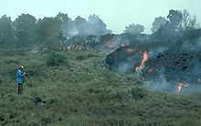 An ʻaʻā lava flow overruns vegetation during the 1984 eruption
The main volcanic hazard at Mauna Loa is lava flows. Most flows advance at about walking pace and present little danger to human life, but eruptions at Mauna Loa can be more intense than those at Kīlauea; for example, the 1984 eruption emitted as much lava in three weeks as Kīlauea's current eruption produces in three years.[33] Such high emission rates can generate comparatively fast-moving flows.
Two eruptions of Mauna Loa have destroyed villages. In 1926, the village of Hoʻōpūloa Makai was overrun by lava flows. In 1950, the most voluminous eruption ever seen at Mauna Loa sent lava flows racing towards the sea. The village of Hoʻokena Mauka was destroyed on June 2, 1950 by the advancing flows.[38] Hilo is partly built on lava from the 1880-81 eruption and is at risk from further lava flows. The brief but intense 1984 eruption saw lava flow towards Hilo, but it had not reached any buildings when the eruption stopped.[39]
Flank collapse
A rarer but potentially greater hazard at Mauna Loa is the possibility of a sudden massive collapse of the volcano's flanks. Deep faults allow large portions of the sides of Hawaiian mountains to slide gradually downwards, the best known example being the Hilina Slump. (There is also the more ancient example of the Ninole Hills.) Occasionally, a large earthquake can trigger a collapse of the flank, creating a massive landslide which may trigger a tsunami. Kealakekua Bay, on the western slope of Mauna Loa, was created by such an event. Undersea surveying has revealed numerous landslides along the Hawaiian chain and two giant tsunamis are known to have occurred: 200,000 years ago, Molokaʻi experienced a 246-foot (75 m) tsunami, and 100,000 years ago a megatsunami 1,066 feet (325 m) high struck Lānaʻi.[13]
A recent example of the risks associated with slumps occurred in 1975, when the Hilina Slump suddenly moved forward by several yards. A magnitude 7.2 earthquake resulted which triggered a small tsunami with a wave height of a few yards, killing two campers at Halape.[40]
Monitoring
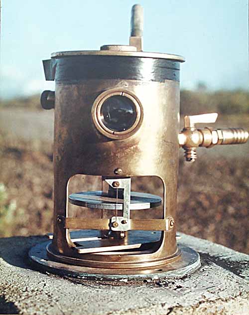
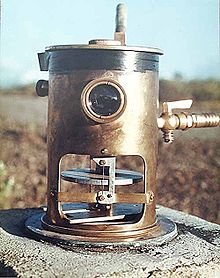 A tiltmeter on Mauna Loa, used to predict eruptions by measuring very small changes in the profile of the mountain.
Mauna Loa is an intensively monitored volcano. The Hawaiian Volcano Observatory (HVO) was established in 1912 to observe the Hawaiian volcanoes, and the HVO has developed many techniques to help predict when eruptions at Mauna Loa and other volcanoes are imminent.
One of the most important tools is seismometry. More than 60 seismometers around the Big Island enable scientists to measure the intensities and locations of hundreds of small earthquakes every week. Earthquakes can begin to increase years before an eruption actually starts: The 1975 and 1984 eruptions were both preceded by one to two years of increased seismic activity at depths of less than 8 miles (13 km).
Another type of seismic activity occurs in the hours preceding an eruption. So-called harmonic tremor is a continuous "rumble" which contrasts with the normal seismic activity of sudden shocks and is believed to be caused by the rapid movement of magma underground. Volcanic tremor normally indicates an imminent eruption, although it may also be caused by shallow intrusions of magma which do not reach the surface.
Another important indicator of what is happening underground is the shape of the mountain. Tiltmeters measure very small changes in the profile of the mountain, and sensitive equipment measures distances between points on the mountain. As magma fills the shallow reservoirs below the summit and rift zones, the mountain inflates. A survey line across the caldera measured a 3-inch (76 mm) increase in its width over the year preceding the 1975 eruption and a similar increase before the 1984 eruption.[13]
Observatories
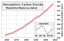
The location of Mauna Loa has made it an important location for atmospheric monitoring by the Global Atmosphere Watch and other scientific observations. The Mauna Loa Solar Observatory (MLSO), located at 11,155 feet (3,400 m) on the northern slope of the mountain, has long been prominent in observations of the Sun. The NOAA Mauna Loa Observatory (MLO) is located close by. From its location well above local human-generated influences, the MLO monitors the global atmosphere, including the greenhouse gas carbon dioxide. Measurements are adjusted to account for local degassing of CO2 from the volcano.[41]
Since October 2006, the Array for Microwave Background Anisotropy (AMIBA) has been exploring the origin of the universe.
The Hawaiian Volcano Observatory maintains seismic sensors and a web cam on Mokuʻāweoweo.[42]
See also
References
- ^ a b "Mauna Loa, Hawaii". Peakbagger.com. http://www.peakbagger.com/peak.aspx?pid=11915. Retrieved 2008-05-17.
- ^ Kaye, G.D. (2002). "Using GIS to estimate the total volume of Mauna Loa Volcano, Hawaii". 98th Annual Meeting. Geological Society of America. http://gsa.confex.com/gsa/2002CD/finalprogram/abstract_34712.htm.
- ^ Biggest Mountain - Mauna Loa
- ^ "Mauna Loa: Earth's Largest Volcano". United States Geological Survey. February 2, 2006. http://hvo.wr.usgs.gov/maunaloa/. Retrieved 2007-07-28.
- ^ MacDonald G, Hubbard DG (1974). Volcanoes of the National Parks of Hawaii. Hawaii Natural History Association Ltd. Retrieved on 2007-07-28.
- ^ a b Rubin, Ken; Rochelle Minicola (2004). "Mauna Loa eruption history". Hawaii Center for Volcanology. http://www.soest.hawaii.edu/GG/HCV/mloa-eruptions.html. Retrieved 2007-07-28.
- ^ When did the summit caldera of Mauna Loa form? United States Geological Survey, Hawaiian Volcano Observatory. March 22, 2001. Retrieved on 2007-07-28.
- ^ What's up with Mauna Loa? United States Geological Survey, Hawaiian Volcano Observatory. October 18, 2001. Retrieved on 2007-07-28.
- ^ Rubin, Ken; Rochelle Minicola (2004). "Mauna Loa Flora and Climate". Hawaii Center for Volcanology. http://www.soest.hawaii.edu/GG/HCV/mloa-flora.html. Retrieved 2007-07-28.
- ^ "lookup of "Mokuaweoweo"". Place Names of Hawaii web site. http://www.wehewehe.org/gsdl2.5/cgi-bin/hdict?a=q&r=1&hs=1&e=q-0hdict--00-0-0--010---4----den--0-000lpm--1haw-Zz-1---Zz-1-home---00031-0000escapewin-00&q=mokuaweoweo&j=pp&hdid=0&hdds=0. Retrieved 2009-10-20.
- ^ a b c Gordon A. Macdonald, Douglass H. Hubbard (Original 1951, revised 1974). Volcanoes of the National Parks of Hawaii. National Park Service web site. http://www.nps.gov/history/history/online_books/hawaii-notes/vol4-2-7d.htm.
- ^ "Hawaii Volcanoes Wilderness Area". Recreation.gov. http://www.recreation.gov/recAreaDetails.do?contractCode=NRSO&recAreaId=5068&agencyCode=145. Retrieved 2009-07-04.
- ^ a b c d Decker R, Decker B (1997). Volcanoes, W.H. Freeman & Co, Ltd, ISBN 0-7167-3174-6
- ^ Lockwood J.P. (1995), "Mauna Loa eruptive history - the preliminary radiocarbon record", in Rhodes, J.M. and Lockwood, J.P. (eds.), Mauna Loa revealed: structure, composition, history, and hazards, Washington D.C., American Geophysical Union Monograph 92, p. 81–94.
- ^ "Eruption History of Mauna Loa Volcano". United States Geological Survey, Hawaiian Volcano Observatory. http://hvo.wr.usgs.gov/maunaloa/history/main.html. Retrieved 2007-07-28.
- ^ "Eruption History: A Cyclic Eruption Model is Proposed". United States Geological Survey, Hawaiian Volcano Observatory. March 16, 1998. http://hvo.wr.usgs.gov/maunaloa/history/model.html. Retrieved 2007-07-28.
- ^ "MAUNA LOA SLOPE OBS, HAWAII". NOAA. http://www.wrcc.dri.edu/cgi-bin/cliMAIN.pl?hi6198.
- ^ "STANLEY, IDAHO- Climate Summary". NOAA. http://www.wrcc.dri.edu/cgi-bin/cliMAIN.pl?hi6198.
- ^ a b Russell A. Apple (July 18, 1973). Ainapo Trail Nomination formPDF (637 KB). National Register of Historic Places, National Park Service.
- ^ a b c Roberta A. Sprague (1991). "Measuring the Mountain: the United States Exploring Expedition on Mauna Loa, 1840-1841". Hawaiian Journal of History (Hawaiian Historical Society, Honolulu) 25. hdl:10524/359.
- ^ a b c Walther M. Barnard (1991). "Earliest Ascents of Mauna Loa Volcano, Hawai'i". Hawaiian Journal of History (Hawaiian Historical Society, Honolulu) 25. hdl:10524/599.
- ^ a b Archibald Menzies (1920). William Frederick Wilson. ed. Hawaii Nei 128 Years Ago: Journal of Archibald Menzies, kept during his three visits to the Sandwich or Hawaiian Islands in the years 1792-1794. s.n.. p. 197. http://books.google.com/?id=11zisSCCOKEC. Retrieved 2009-07-04.
- ^ a b "National Register Information System". National Register of Historic Places. National Park Service. 2009-03-13. http://nrhp.focus.nps.gov/natreg/docs/All_Data.html.
- ^ Charles Wilkes (1849). Narrative of the United States Exploring Expedition. Volume IV. G. P. Putnam. p. Pages 111–162. http://books.google.com/?id=lbMNAAAAQAAJ.
- ^ a b c Russell A. Apple (1973). "Wilkes Campsite Nomination form". National Register of Historic Places. National Park Service. http://pdfhost.focus.nps.gov/docs/NRHP/Text/74000295.pdf.
- ^ Historic Places in Hawaii County on official state web site
- ^ "NOAA Mauna Loa Observatory". National Oceanic and Atmospheric Administration web site. http://www.mlo.noaa.gov. Retrieved 2009-07-04.
- ^ a b c Eruption History of Mauna Loa from the USGS
- ^ USAF history page (PDF). 27 Dec 1935 Five Keystone LB-5 bombers of the 23d and 72d Bombardment Squadrons at Luke Field dropped twenty 600-pound bombs in the path of a lava flow from the Mauna Loa volcano on the Big Island.
- ^ 23rd Bomb Squadron history from Minot Air Force Base website.
- ^ "TERRITORIES: Mauna Loa Erupts". Time. April 22, 1940. http://www.time.com/time/magazine/article/0,9171,763845,00.html.
- ^ "50th Anniversary of Mauna Loa's Most Spectacular Eruption". USGS Hawaii Volcano Observatory. 2000. http://hvo.wr.usgs.gov/maunaloa/history/50_06_01. Retrieved 2009-07-04.
- ^ a b "The 1950 eruption of Mauna Loa: a nightmare that could reoccur". USGS, Hawaiian Volcano Observatory. May 10, 2001. http://hvo.wr.usgs.gov/volcanowatch/2001/01_05_10.html. Retrieved 2007-07-28.
- ^ "1984 Eruption of Mauna Loa". USGS Hawaiian Volcano Observatory. 1987. http://hvo.wr.usgs.gov/maunaloa/history/1984.html. Retrieved 2009-07-04.
- ^ "Mauna Loa: Summary of monitoring data (1970 – May 2005)". United States Geological Survey, Hawaiian Volcano Observatory. June 22, 2005. http://hvo.wr.usgs.gov/maunaloa/current/longterm.html. Retrieved 2007-07-28.
- ^ a b "Inflation of Mauna Loa Volcano slows". USGS, Hawaiian Volcano Observatory. January 23, 2003. http://hvo.wr.usgs.gov/volcanowatch/2003/03_01_23.html. Retrieved 2007-07-28.
- ^ Heliker CC (July 18, 1997). "Volcanic and seismic hazards on the island of Hawaii". US Geological Survey General Interest Publication. http://pubs.usgs.gov/gip/hazards/hazards.html. Retrieved 2007-07-28.
- ^ Finch R.H., Macdonald G.A. (1950), The June 1950 eruption of Mauna Loa, Part I, Volcano Letter, v.508, p12
- ^ "Lava flow hazards on Mauna Loa volcano". USGS, Hawaiian Volcano Observatory. February 2, 2006. http://hvo.wr.usgs.gov/maunaloa/hazards/main.html. Retrieved 2007-07-28.
- ^ Cannon EC, Bürgmann R, Owen SE (2001), Shallow Normal Faulting and Block Rotation Associated with the 1975 Kalapana Earthquake, Kilauea, Bulletin of the Seismological Society of America
- ^ Rhodes, J.M. and Lockwood, J. P. (editors), (1995) Mauna Loa Revealed: Structure, Composition, History, and Hazards, Washington D.C., American Geophysical Union Monograph 92, page 95
- ^ "Live panorama of Mokuaweoweo". United States Geological Survey, Hawaii Volcanoes Observatory web site. http://hvo.wr.usgs.gov/cam2. Retrieved 2009-07-04.
External links
- United States Geological Survey information page
- VolcanoWorld information
- Hawaii Center for Volcanology pages
- Global Volcanism Program entry
- Mauna Loa Observatory (MLO) – NOAA
- Mauna Loa Solar Observatory (MLSO)
- 1934 USGS color video (silent) of Mauna Loa erupting
Hawaiian volcanism topics (List) Windward
Isles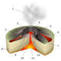
Leeward
IslesEmperor
SeamountsTopics Hawaiian – Emperor seamount chain · Evolution of Hawaiian volcanoes · Hawaiian eruption · ʻAʻā (lava) · Pāhoehoe (lava) · Pele's hair · Limu o Pele · Pele's tears · Lava fountain · Hawaiian Volcano Observatory · Hawaii Volcanoes National Park · Haleakala National Park · 1955 Hawaiian submarine eruptionDecade Volcanoes Avachinsky · Colima · Etna · Galeras · Koryaksky · Mauna Loa · Merapi · Nyiragongo · Rainier · Sakurajima · Santa María · Taal · Teide · Ulawun · Unzen · VesuviusU.S. National Register of Historic Places Topics Lists by states Alabama • Alaska • Arizona • Arkansas • California • Colorado • Connecticut • Delaware • Florida • Georgia • Hawaii • Idaho • Illinois • Indiana • Iowa • Kansas • Kentucky • Louisiana • Maine • Maryland • Massachusetts • Michigan • Minnesota • Mississippi • Missouri • Montana • Nebraska • Nevada • New Hampshire • New Jersey • New Mexico • New York • North Carolina • North Dakota • Ohio • Oklahoma • Oregon • Pennsylvania • Rhode Island • South Carolina • South Dakota • Tennessee • Texas • Utah • Vermont • Virginia • Washington • West Virginia • Wisconsin • WyomingLists by territories Lists by associated states Other Categories:- Active volcanoes
- Decade Volcanoes
- Extreme points of Earth
- Mountains of Hawaii
- United States National Park high points
- Shield volcanoes
- Volcanic calderas of Hawaii
- Volcanoes of the Island of Hawaii
- Hotspot volcanoes
- VEI-2 volcanoes
- Hawaiʻi Volcanoes National Park
- National Register of Historic Places in Hawaii
- Pleistocene volcanoes


Wikimedia Foundation. 2010.