- Daikakuji Guyot
-
Daikakuji Seamount 
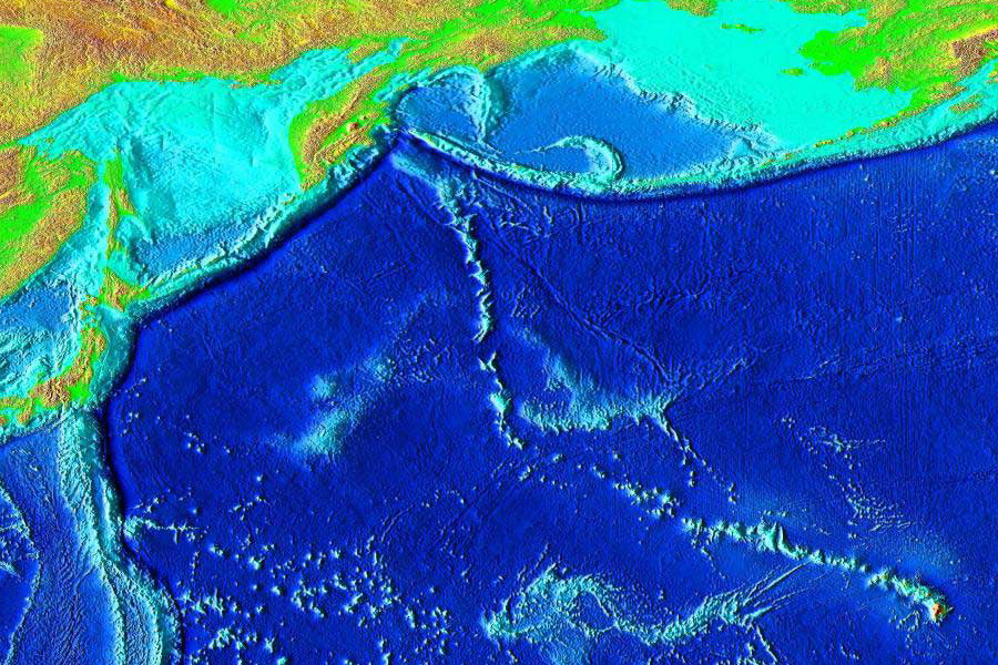
Elevation of the Pacific seafloor, showing the Hawaiian-Emperor seamount chain, including Daikakuji Seamount near the prominent "V"-shaped bend, which separates the Hawaiian Ridge from the older Emporer Seamount portion of the chain.Summit depth 1,000 m (3,281 ft) Height 4,000 m (157,480 in) Summit area 30 km (19 mi) diameter Location Location Central Pacific Ocean Group Emporer seamounts Coordinates 32°5.00′N 172°18′E / 32.083°N 172.3°ECoordinates: 32°5.00′N 172°18′E / 32.083°N 172.3°E Geology Type Guyot Volcanic arc/chain Hawaiian-Emperor seamount chain Age of rock 43 million years History First visit GLORIA program, USGS[1][2] Daikakuji Seamount is a seamount (underwater volcano) and the southwesternmost volcanic feature in the Hawaiian Emperor chain bend area. The seamount is very close to the "V"-shaped bend in the Hawaiian-Emperor seamount chain, and thus would be useful in understanding the exact age of the bend. Although few dredge samples are available, they have all been reliably dated at 43 million years.
During the cruise SO112 of the R/V SONNE, high resolution bathymetric mapping was conducted, showing that Daikakuji is nearly 30 km (19 mi) in diameter and nearly 4,000 m (157,480 in) in height, with a summit lying 1,000 m (3,281 ft) underwater. Because of its flat capped top, Daikakuji is considered a guyot. A smaller, younger, secondary guyot just east of the main mass overlaps its slope. The western site suffered a large collapse sometime in its history, evident by a large slump, that likely carried away a significant part of the volcano's caldera. Daikakuji Seamount has some well developed rift zones oriented towards the Emperor portion of the chain, whereas the younger, secondary cone has rift flanks in the direction of the Hawaiian ridge.
References
- ^ "Siesmic stratigraphy of Detroit Seamount, Hawaiian-Emporer Seamount chain". Scientific Publication. Stanford University. 12 July 2005. http://pangea.stanford.edu/research/groups/crustal/docs/Kerr.DetroitSeamount.G3.2005.pdf. Retrieved 2009-04-03.
- ^ "DRILLING STRATEGY". OCean Drilling Program. http://www-odp.tamu.edu/publications/prosp/197_prs/197drill.html. Retrieved 2009-04-04.
Hawaiian volcanism topics (List) Windward
Isles
Leeward
IslesEmperor
SeamountsTopics Hawaiian – Emperor seamount chain · Evolution of Hawaiian volcanoes · Hawaiian eruption · ʻAʻā (lava) · Pāhoehoe (lava) · Pele's hair · Limu o Pele · Pele's tears · Lava fountain · Hawaiian Volcano Observatory · Hawaii Volcanoes National Park · Haleakala National Park · 1955 Hawaiian submarine eruptionCategories:- Hotspot volcanoes
- Guyots
- Seamounts of the Pacific Ocean

Wikimedia Foundation. 2010.