- Okmulgee, Oklahoma
-
Okmulgee, Oklahoma — City — Location of Okmulgee, Oklahoma
Coordinates: 35°37′28″N 95°57′48″W / 35.62444°N 95.96333°WCoordinates: 35°37′28″N 95°57′48″W / 35.62444°N 95.96333°W Country United States State Oklahoma County Okmulgee Government - Type Council-Manager Area - Total 12.8 sq mi (33.2 km2) - Land 12.8 sq mi (33.2 km2) - Water 0.0 sq mi (0.0 km2) Elevation 686 ft (209 m) Population (2009) - Total 12,558 - Density 981.1/sq mi (378.3/km2) Time zone Central (CST) (UTC-6) - Summer (DST) CDT (UTC-5) ZIP code 74447 Area code(s) 539/918 FIPS code 40-55150[1] GNIS feature ID 1096218[2] Website www.okmulgeeonline.com Okmulgee is a city in Okmulgee County, Oklahoma, United States. The population at the 2010 census was 12,321 a loss of 5.4 percent since the 2000 census figure of 13,022.[3] It has been the capital of the Muscogee (Creek) Nation since the United States Civil War. Okmulgee means "boiling waters" in the Creek language. The site was chosen because of the nearby rivers and springs.[4]
Contents
Geography
Okmulgee is located at 35°37′28″N 95°57′48″W / 35.62444°N 95.96333°W (35.624558, -95.963254)[5].
According to the United States Census Bureau, the city has a total area of 33.8 square miles (33.2 km²), all of it land. Actually, Okmulgee means "babbling brook", it is also translated as 'Effluvium'. It's located in the heart of Oklahoma's "Green Country", in the North East Quadrant of Oklahoma. It is also home to Oklahoma State University Institute of Technology.
Demographics
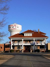 Elks Lodge and Water Tower in Okmulgee, Oklahoma
As of the census[1] of 2000, there were 13,022 people, 5,135 households, and 3,291 families residing in the city. The population density was 1,015.7 people per square mile (392.2/km²). There were 5,948 housing units at an average density of 463.9 per square mile (179.1/km²). The racial makeup of the city was 58.85% White, 21.29% African American, 13.61% Native American, 0.29% Asian, 0.02% Pacific Islander, 0.53% from other races, and 5.41% from two or more races. Hispanic or Latino of any race were 1.83% of the population.
There were 5,135 households out of which 30.0% had children under the age of 18 living with them, 42.7% were married couples living together, 17.6% had a female householder with no husband present, and 35.9% were non-families. 32.1% of all households were made up of individuals and 14.0% had someone living alone who was 65 years of age or older. The average household size was 2.38 and the average family size was 3.00.
In the city the population was spread out with 25.4% under the age of 18, 12.7% from 18 to 24, 24.3% from 25 to 44, 21.1% from 45 to 64, and 16.5% who were 65 years of age or older. The median age was 36 years. For every 100 females there were 93.3 males. For every 100 females age 18 and over, there were 87.5 males.
The median income for a household in the city was $24,344, and the median income for a family was $31,015. Males had a median income of $26,105 versus $19,722 for females. The per capita income for the city was $13,633. About 19.6% of families and 54.1% of the population were below the poverty line, including 33.0% of those under age 18 and 14.1% of those age 65 or over.
Education
CareerTech
- Green Country Technology Center is located in Okmulgee
Post Secondary
- College of the Muscogee Nation[6]
- Oklahoma State University-Okmulgee
Transportation
Okmulgee is served by U.S. Route 75, a major national north/south artery for much of its length, currently running from the Canadian border at Noyes Minnesota to Dallas, Texas.[7]
Okmulgee is in the 10-county region served by the KI BOIS Area Transit System ("KATS"), a low-cost public bus/van service established in 1983 to help poorer communities, primarily in southeast Oklahoma, by providing access to Senior Citizen centers, groceries, medical services, and jobs. [8]
The city is served by the Okmulgee Regional Airport (originally called the Okmulgee Municipal Airport), designated OKM by IATA Code and KOKM by ICAO Code.[9] Construction of this airport was authorized in 1942 as a national defense project, and was completed on September 7, 1943. The main runway (18-36) is concrete-surfaced, 100' wide and 5,150' long.[10]
Parks and Recreation
Recreational opportunities include Okmulgee and Dripping Springs State Parks, which offer RV and camping facilities.[11][12] The parks also offer swimming, fishing and boating opportunities through the adjacent Dripping Springs Lake, which has 18 miles (29 km) of shoreline and 1,150 acres (4,700,000 m2) of water, and the separate Okmulgee Lake. The end of Okmulgee Lake features the Okmulgee Lake Spillway, which on occasions of heavy rains and high lake levels, creates an intense man-made waterfall. Nearby to Okmulgee is the Deep Fork National Wildlife Refuge.[13] Established in 1993, this approximately 9,000 acres (36 km2) habitat for waterfowl along the Deep Fork River features opportunities for wildlife viewing such as along the Cussetah Bottoms Boardwalk, as well as fishing and certain archery, muzzle-loading, and small-game hunting opportunities.[14]
Events
Okmulgee is known for its annual Okmulgee Invitational Rodeo and Festival, which is the nation's oldest African-American rodeo and one of the state's longest running rodeos.[15]
Native American government
The Muscogee (Creek) Nation, one of the historical Five Civilized Tribes, is headquartered in Okmulgee. [16] Okmulgee is also the site of the original Creek Council House. Built by the Muscogee (Creek) Nation as a capitol building in 1878, the Council House was eventually sold to the City of Okmulgee where it served various purposes over the years, including a Sheriff's office, a YMCA, and more recently, a Creek Council House Museum. The City agreed in August of 2010 to resell the building to the Creek Nation, and the ceremony commemorating the repossession of the building was held in November of 2010.[17]
Notable residents
- Patrick Collins, NFL player
- Ron Gardenhire, manager of the MLB team the Minnesota Twins
- Mel McDaniel, country musician
- David Obey, US Congressman, birthplace
- Oscar Pettiford, jazz bass player
- Will Sampson, actor
- Bill Self, college basketball coach, birthplace
References
- ^ a b "American FactFinder". United States Census Bureau. http://factfinder.census.gov. Retrieved 2008-01-31.
- ^ "US Board on Geographic Names". United States Geological Survey. 2007-10-25. http://geonames.usgs.gov. Retrieved 2008-01-31.
- ^ [ttp://www.muninetguide.com/states/oklahoma/okmulgee/]
- ^ Oklahoma Almanac pp. 468-469. Accessed January 15, 2007.
- ^ "US Gazetteer files: 2010, 2000, and 1990". United States Census Bureau. 2011-02-12. http://www.census.gov/geo/www/gazetteer/gazette.html. Retrieved 2011-04-23.
- ^ "FAQ." College of the Muscogee Nation. (retrieved 27 Dec 2010)
- ^ "U.S. Highway 75 Endpoints". http://www.usends.com/70-79/075/075.html. Retrieved 2011-06-15.
- ^ "Oklahoma Department of Transportation Website-- KI BOIS Area Transit System". http://www.okladot.state.ok.us/transit/s5311/kibois.htm. Retrieved 2011-06-15.
- ^ "List of Airports by IATA Code-- Letter O". http://en.wikipedia.org/wiki/List_of_airports_by_IATA_code:_O. Retrieved 2011-06-15.
- ^ "Okmulgee Airport website, History". http://www.okmulgeeairport.org/history.html. Retrieved 2011-06-15.
- ^ "TravelOK Website--Dripping Springs". http://www.travelok.com/listings/view.profile/id.2368. Retrieved 2011-06-15.
- ^ "TravelOK Website--Okmulgee State Park". http://www.travelok.com/listings/view.profile/id.5520. Retrieved 2011-06-15.
- ^ "U.S. Fish and Wildlife Service website, Deep Fork". http://www.fws.gov/southwest/refuges/oklahoma/Deep%20Fork/. Retrieved 2011-06-15.
- ^ "TravelOK--Deep Fork". http://www.travelok.com/listings/view.profile/id.2157. Retrieved 2011-06-15.
- ^ "TravelOK Website-- Okmulgee Invitational Rodeo and Festival". http://www.travelok.com/listings/view.profile/id.13871. Retrieved 2011-06-15.
- ^ "Muscogee (Creek) Nation Website". http://www.muscogeenation-nsn.gov/. Retrieved 2011-06-15.
- ^ "Tulsa World, November 15, 2010". http://www.tulsaworld.com/news/article.aspx?subjectid=11&articleid=20101115_11_A13_CUTLIN80706&archive=yes. Retrieved 2011-06-15.
External links
- Memoirs of Jeremiah Curtin in the Indian Territory ethnographer's notes of 1883 visits to Muskogee and Okmulgee; electronic record maintained by Library of Congress, accessed January 15, 2007.
Municipalities and communities of Okmulgee County, Oklahoma Cities 
Towns Unincorporated
communitiesBaldhill | Bartlett | Bryant | Coalton | Dighton | Eram | Four Corners | Gulftown | Kusa | Natura | Nuyaka | Preston | Pumpkin Center | Spelter City | Wilson
Footnotes ‡This populated place also has portions in an adjacent county or counties
County seats in Oklahoma Ada • Altus • Alva • Anadarko • Antlers • Arapaho • Ardmore • Arnett • Atoka • Bartlesville • Beaver • Boise City • Buffalo • Chandler • Chelsea • Cherokee • Cheyenne • Chickasha • Claremore • Coalgate • Duncan • Durant • El Reno • Enid • Eufaula • Fairview • Frederick • Guthrie • Guymon • Hobart • Holdenville • Hollis • Hugo • Idabel • Jay • Kingfisher • Lawton • Madill • Mangum • Marietta • McAlester • Medford • Miami • Muskogee • New Cordell • Newkirk • Nowata • Okemah • Oklahoma City • Okmulgee • Pauls Valley • Pawhuska • Pawnee • Perry • Poteau • Pryor • Purcell • Sallisaw • Sapulpa • Sayre • Shawnee • Stigler • Stillwater • Stilwell • Sulphur • Tahlequah • Taloga • Tishomingo • Tulsa • Vinita • Wagoner • Walters • Watonga • Waurika • Wewoka • Wilberton •
WoodwardCategories:- Cities in Oklahoma
- County seats in Oklahoma
- Populated places in Okmulgee County, Oklahoma
- United States colonial and territorial capitals


Wikimedia Foundation. 2010.