- Okemah, Oklahoma
-
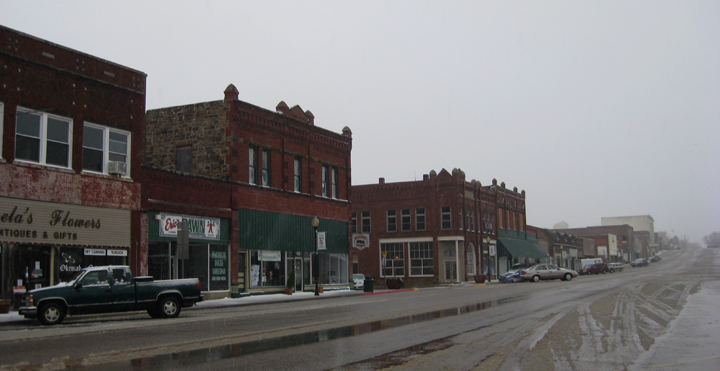
Okemah, Oklahoma — City — West Broadway, Downtown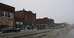 Location of Okemah, Oklahoma
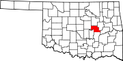
Coordinates: 35°25′52″N 96°18′20″W / 35.43111°N 96.30556°WCoordinates: 35°25′52″N 96°18′20″W / 35.43111°N 96.30556°W Country United States State Oklahoma County Okfuskee Area - Total 2.7 sq mi (6.9 km2) - Land 2.6 sq mi (6.7 km2) - Water 0.1 sq mi (0.2 km2) Elevation 909 ft (277 m) Population (2000) - Total 3,038 - Density 1,170.5/sq mi (451.9/km2) Time zone Central (CST) (UTC-6) - Summer (DST) CDT (UTC-5) ZIP code 74859 Area code(s) 539/918 FIPS code 40-54200[1] GNIS feature ID 1096198[2] Okemah is a city in Okfuskee County, Oklahoma, United States. It is the county seat of Okfuskee County.[3] It is the birthplace of folk music legend Woody Guthrie. Thlopthlocco Tribal Town, a federally recognized Muscogee Indian tribe, is headquartered in Okemah. The population was 3,038 at the 2000 census and about 23 percent of the residents identified as American Indian.
Contents
History
Historically occupied by the Osage and Quapaw, who ceded their lands to the United States by 1825, after Indian Removal of tribes from the Southeast United States in the 1830s, this area was assigned to the Creek Nation and specifically, the Thlopthlocco Tribal Town.
Okemah was named after a Kickapoo Indian chief named Chief Okemah. In March 1902, Chief Okemah built a bark house in his tribe's traditional fashion. He had come to await the opening of the townsite which took his name April 22, 1902. In the Kickapoo language, okemah means "things up high," such as highly placed person or town or high ground. Okemah had the chief's name to live up to in leadership.
In preparation for Oklahoma's being admitted as a state, the Dawes Commission was authorized in 1896 to work with the Five Civilized Tribes to enroll their members for allotments of tribal land to individual households. Registration of tribal members lasted from 1898-1906. After allotment, the government was going to declare as "surplus" the remaining tribal lands, and sell them to European-American settlers.
Okemah was platted by a group of Shawnee residents in March 1902 on land belonging to Mahala and Nocus Fixico, full-blood Creek. The Fixicos had no legal right at the time to sell their holding, as enrollment of tribal members on the Dawes Roll continued until 1906, and no land sales were to take place by Indians until it was completed. That did not appear to affect the promoters or the development of the town.
On April 22, 1902 the formal opening launched the town. It was incorporated in 1903. In the spring of 1904, Commission restrictions on the sale of townsite lots were removed. The Department of Interior trustees of land held by American Indians paid the Fixicos $50 an acre for their land, and gave legal deeds to the purchasers who claimed title.
In the town's first week, the following stores were established: four general merchandise, two hardware, one 5 & 10 cent store, three drug stores, four grocery stores, three wagon yards, four lumber yards, three cafes, one bakery, two millinery stores, four livery barns, three blacksmiths, two dairies, two cotton gins and two weekly newspapers. Eight doctors settled there, four lawyers, two walnut log buyers, and one Chinese laundryman. Two hotels were quickly put up, including the three-story Broadway hotel which set the city apart as an important town in early-day Oklahoma.
Okfuskee County had been organized at the time of statehood in 1907. Okemah was chosen as county seat in a county election held August 27, 1908.
"Firsts" in various spheres
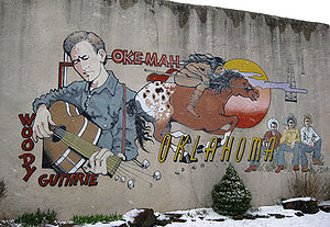 Mural by DeAnna Wilson, depicting Woody Guthrie and Okfuskee County history, 510 W. Broadway, Okemah
It was Perry Rodkey and H.R. Dexter who first surveyed the townsite.
The town's first state-chartered bank began business the day of the opening, April 22, 1903 in a tent on the northwest corner of the present Fifth and Broadway (now City Hall). C. J. Benson was president. W. H. Dill was vice president and served as cashier. It became the First National Bank in 1903, but was liquidated in 1939, having failed due to the Dust Bowl and the Great Depression.
J. E. Galloway was the first mayor; Perry Rodkey, first postman; E. D. Dexter, first hotel operator; W. H. Dill ran the first telephone company; John D. Richards had the first hardware store; McGee Brothers put in the first cotton gin and E. E. Shook established the first lumber yard. The first church in the city was the North Methodist, at Sixth and Ash, but the first church service Baptist, presided over by the Rev. Black. The editor Charles Barnclaw published the first newspaper.
Development of education
S. L. O'Bannon was the teacher in the first school, which was opened in 1902 with funds gained by subscribers. Classes were held in a store building. The first school building was built in 1902. It was later replaced by the Wilson School on the same site. The first public school was opened with Dr. Z. Cheatwood as superintendent in 1904.
A store building housed one of the first public schools, and the other was held in a building where the American Legion building now stands. Noble School, completed in 1907, was named for Miss Mae Noble. Okemah High School gained accreditation in 1912. It met in the old Noble School building until the building of 1918 was erected. In the high school complex, the band shop building was erected 1941 and a vocational building in 1948.
Vigilantes and lynching
Main article: Lynching of Laura and Lawrence NelsonThough a police force was organized in the town soon after its founding (a Mr. Franklin wore the first city policeman's badge), vigilantes were active during Okemah's early years. Law enforcement and justices of the peace were located some distance away. They appeared to have had almost complete freedom of action.
In 1911, a black woman, 35-year old Laura Nelson, and her 15-year-old son Lawrence were lynched by a mob of 40 white men. Accused of killing a police officer in an altercation at their home near Paden, they were kidnapped after being held at the jail and the county courthouse. They were hanged from a suspension bridge over the North Canadian River.[4]
Notable Okemahns
- Woody Guthrie - Folk singer
- Gwen Guthrie - R&B singer
- William Reid Pogue - astronaut
- Larry Coker - Football coach
- Deloss Mcgraw- Painter
Geography
Okemah is located at 35°25′52″N 96°18′20″W / 35.43111°N 96.30556°W (35.430987, -96.305500)[5].
According to the United States Census Bureau, the city has a total area of 2.7 square miles (7.0 km2), of which, 2.6 square miles (6.7 km2) of it is land and 0.1 square miles (0.26 km2) of it (2.63%) is water.
Demographics
As of the census[1] of 2000, there were 3,038 people, 1,242 households, and 763 families residing in the city. The population density was 1,170.5 people per square mile (451.1/km²). There were 1,506 housing units at an average density of 580.3 per square mile (223.6/km²). The racial makeup of the city was 69.09% White, 2.37% African American, 22.84% Native American, 0.10% Asian, 0.46% from other races, and 5.13% from two or more races. Hispanic or Latino of any race were 1.94% of the population.
There were 1,242 households out of which 29.5% had children under the age of 18 living with them, 41.8% were married couples living together, 15.0% had a female householder with no husband present, and 38.5% were non-families. 35.7% of all households were made up of individuals and 18.4% had someone living alone who was 65 years of age or older. The average household size was 2.35 and the average family size was 3.04.
In the city the population was spread out with 27.4% under the age of 18, 8.9% from 18 to 24, 23.3% from 25 to 44, 19.9% from 45 to 64, and 20.5% who were 65 years of age or older. The median age was 37 years. For every 100 females there were 82.2 males. For every 100 females age 18 and over, there were 76.8 males.
The median income for a household in the city was $21,306, and the median income for a family was $26,659. Males had a median income of $21,905 versus $15,375 for females. The per capita income for the city was $12,645. About 19.5% of families and 25.3% of the population were below the poverty line, including 38.6% of those under age 18 and 16.6% of those age 65 or over.
References
- ^ a b "American FactFinder". United States Census Bureau. http://factfinder.census.gov. Retrieved 2008-01-31.
- ^ "US Board on Geographic Names". United States Geological Survey. 2007-10-25. http://geonames.usgs.gov. Retrieved 2008-01-31.
- ^ "Find a County". National Association of Counties. http://www.naco.org/Counties/Pages/FindACounty.aspx. Retrieved 2011-06-07.
- ^ "Laura and Lawrence Nelson", Strange Fruit Website
- ^ "US Gazetteer files: 2010, 2000, and 1990". United States Census Bureau. 2011-02-12. http://www.census.gov/geo/www/gazetteer/gazette.html. Retrieved 2011-04-23.
Municipalities and communities of Okfuskee County, Oklahoma County seat: Okemah City Okemah
Towns Unincorporated
communitiesCounty seats in Oklahoma Ada • Altus • Alva • Anadarko • Antlers • Arapaho • Ardmore • Arnett • Atoka • Bartlesville • Beaver • Boise City • Buffalo • Chandler • Chelsea • Cherokee • Cheyenne • Chickasha • Claremore • Coalgate • Duncan • Durant • El Reno • Enid • Eufaula • Fairview • Frederick • Guthrie • Guymon • Hobart • Holdenville • Hollis • Hugo • Idabel • Jay • Kingfisher • Lawton • Madill • Mangum • Marietta • McAlester • Medford • Miami • Muskogee • New Cordell • Newkirk • Nowata • Okemah • Oklahoma City • Okmulgee • Pauls Valley • Pawhuska • Pawnee • Perry • Poteau • Pryor • Purcell • Sallisaw • Sapulpa • Sayre • Shawnee • Stigler • Stillwater • Stilwell • Sulphur • Tahlequah • Taloga • Tishomingo • Tulsa • Vinita • Wagoner • Walters • Watonga • Waurika • Wewoka • Wilberton •
WoodwardCategories:- Cities in Oklahoma
- Populated places in Okfuskee County, Oklahoma
- County seats in Oklahoma


Wikimedia Foundation. 2010.