- Duncan, Oklahoma
-
Duncan, Oklahoma — City —  Location of Duncan, Oklahoma
Coordinates: 34°31′0″N 97°56′58″W / 34.516667°N 97.94944°WCoordinates: 34°31′0″N 97°56′58″W / 34.516667°N 97.94944°W Country United States State Oklahoma County Stephens Area – Total 46.0 sq mi (119.1 km2) – Land 38.8 sq mi (100.5 km2) – Water 7.2 sq mi (18.7 km2) Elevation 1,122 ft (342 m) Population (2010) – Total 23,431 Time zone Central (CST) (UTC-6) – Summer (DST) CDT (UTC-5) ZIP codes 73533-73599 Area code(s) 580 FIPS code 40-21900[1] GNIS feature ID 1092291[2] Duncan is a city in Stephens County, Oklahoma, United States. The population was 23,431 at the 2010 census. It is the county seat of Stephens County.[3]
The official birthdate of the town is considered to be when the first train arrived there on June 27, 1892. Statehood in 1907 turned the town into the county seat and a number of oil wells in Stephens County led to Duncan's rapid development in 1918.[4]
Contents
History
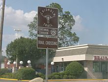
The Chisholm Trail passed to the east of Duncan prior to the town's founding.[4] An estimated 9,800,000 Longhorn cattle were herded up the trail between Texas and Abilene, Kansas during its existence. After learning that an extension of the Chicago, Rock Island and Pacific Railroad was being built from Kansas to Texas, Scotsman William Duncan brought his wife, parents, and other relatives and created a trading post situated at the intersection of the north-south Chisholm Trail and the east-west military passage between Fort Arbuckle and Fort Sill. The first train arrived on June 27, 1892; that date is considered the official birthdate of the town.
Many of the city's first buildings were woodframe, but were replaced by sandstone and brick structures after natural disasters destroyed them.[5] Four fires in 1901 burned down several buildings.[5]
Centrally located in Stephens County, Duncan became the county seat after Oklahoma achieved statehood in 1907.[4] As a compromise between residents of the northern and southern parts of the county, the county courthouse was located in the middle of Duncan's Main Street, half of it in the northern part of the city and county and half in the southern. Main Street made a wide circle around it on both ends.
Oil wells opened in Stephens County in 1918 and led to rapid development in Duncan.[4] Shacks were prohibited immediately following the opening of the wells and other regulations were also put in place to channel the growth in an organized manner.[4]
Several Tudor Revival style homes were built in the 1930s.[5] Works Progress Administration projects meant to rebuild the economy after the Great Depression resulted in a public library, a senior high school, a stadium, a pool, a school and auditorium for the black community, an armory, and numerous bridges and sidewalks.[5]
Duncan expanded its city limits during an economic surge brought on by World War II.[5] Towards the end of this period, the downtown area began to see a decline.[5]
Geography
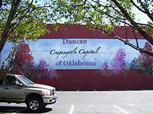 Crape Myrtle Capital of Oklahoma Painting on downtown Duncans theater
Duncan is located at 34°31′0″N 97°56′58″W / 34.516667°N 97.94944°W (34.516619, -97.949377).[6] The town is situated approximately 30 miles East of Lawton, Oklahoma and 90 miles Southwest of Oklahoma City, Oklahoma along US Highway 81.
According to the United States Census Bureau, the city has a total area of 46.0 square miles (119 km2). 38.8 square miles (100 km2) of it is land and 7.2 square miles (19 km2) of it (15.67%) is water.
Duncan is known for crapemyrtle trees, Oklahoma prairie and rich farmland.[7] State lawmakers designated the city as Oklahoma's official "Crapemyrtle Capital".[8] Oklahoma's grasslands are made up of shortgrass, mixed-grass and tallgrass prairie.[9] The city is part of the Great Plains and has multiple lakes.[10] The city has four lakes.[11]
Duncan receives 34 inches of rain per year, but only five inches of snowfall. The city also receives an average of 241 sunny days per year. It lies 1,128 feet above sea level.[12]
Duncan's buildings listed on the National Register of Historic Places include the Johnson Hotel and Boarding House, the Chrislip House, the Duncan Armory, the Patterson Hospital and the old Duncan library.[5] The downtown area lies between Walnut and Willow avenues, from the railroad tracks to State Highway 81.[5]
Climate
Climate data for Duncan, Oklahoma Month Jan Feb Mar Apr May Jun Jul Aug Sep Oct Nov Dec Year Record high °F (°C) 84
(29)88
(31)97
(36)96
(36)99
(37)106
(41)110
(43)110
(43)108
(42)101
(38)90
(32)88
(31)110
(43)Average high °F (°C) 52
(11)57
(14)65
(18)76
(24)82
(28)90
(32)95
(35)96
(36)89
(32)78
(26)64
(18)55
(13)75 Average low °F (°C) 29
(−2)33
(1)40
(4)51
(11)59
(15)68
(20)71
(22)71
(22)64
(18)53
(12)39
(4)32
(0)51 Record low °F (°C) −8
(−22)−3
(−19)2
(−17)26
(−3)34
(1)49
(9)55
(13)56
(13)36
(2)26
(−3)14
(−10)5
(−15)−8
(−22)Precipitation inches (mm) 1.4
(36)1.8
(46)2
(51)3
(76)6.4
(163)4.5
(114)2.7
(69)2.4
(61)2.5
(64)3.4
(86)1.5
(38)1.5
(38)33
(838)Snowfall inches (cm) 2
(5)2.2
(5.6)1
(3)0.3
(0.8)1.5
(3.8)7
(18)% humidity 70 67 61 60 68 65 63 58 58 63 63 66 64 Avg. rainy days 3.5 4.3 4.8 6.1 7.6 7.3 5.2 4.8 4.3 5.5 2.9 3.8 60.1 Source no. 1: weather.com Source no. 2: Weatherbase.com [13] Demographics
As of the census of 2000, there were 22,505 people, 9,406 households, and 6,424 families residing in the city. The population density was 580.2 inhabitants per square mile (224.0/km²). There were 10,795 housing units at an average density of 278.3 per square mile (107.4/km²). The racial makeup of the city was 90.48% White, 1.07% African American, 2.95% Native American, 0.47% Asian, 0.04% Pacific Islander, 2.36% from other races, and 2.63% from two or more races. Hispanic or Latino of any race were 5.99% of the population.
There were 9,406 households out of which 28.8% had children under the age of 18 living with them, 54.6% were married couples living together, 10.4% had a female householder with no husband present, and 31.7% were non-families. 28.9% of all households were made up of individuals and 14.7% had someone living alone who was 65 years of age or older. The average household size was 2.35 and the average family size was 2.88.
In the city the population was spread out with 24.1% under the age of 18, 8.3% from 18 to 24, 24.8% from 25 to 44, 22.6% from 45 to 64, and 20.2% who were 65 years of age or older. The median age was 40 years. For every 100 females there were 89.8 males. For every 100 females age 18 and over, there were 85.3 males.
The median income for a household in the city was $30,373, and the median income for a family was $37,080. Males had a median income of $31,173 versus $19,731 for females. The per capita income for the city was $17,643. About 28.7% of families and 27.4% of the population were below the poverty line, including 22.1% of those under age 18 and 42.8% of those age 65 or over.
Economy
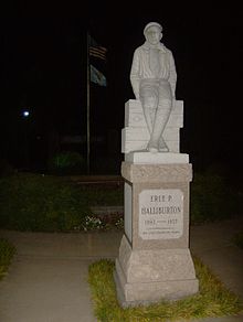
Duncan once adopted the slogan, "The Buckle on the Oil Belt". Its main claim to fame is as the birthplace of the Halliburton Corporation.[4] Erle P. Halliburton perfected a new method of cementing wells, making oil production much easier and more profitable, and established the New Method Oil Well Cementing Company in 1919. He died in 1957, at which time the company had 201 offices in 22 states and 20 foreign countries. Halliburton maintains seven different complexes in Duncan plus an employee recreational park, but the corporate offices relocated first to Dallas and later to Houston.
Halliburton operates the Halliburton Technology Center in Duncan. In 2010 Halliburton announced that 150 jobs in the center will move to Houston over the following two years.[14]
Agriculture has always played a part in Duncan's economy. Cotton was a dominant crop until the Dust Bowl brought about a reduction in its role.[5] Cattle remains an important part of Duncan's economy.[5]
The city has been home to a number of banks and doctors since its early settlement and both continue to be well-represented today.[5]
Arts and Culture
Duncan is home to the Chisholm Trail Heritage Center. The Stephens County Historical Museum contains displays and artifacts from the land run and early settlement in the area.[11]
The city holds an annual county fair and top-rated livestock events year round.[11] Other annual events include the Trail Dance Film Festival, Cruizin’ the Chisholm Trail Car and Motorcycle Show, the Chisholm Trail Stampede, Summerfest with the World’s Largest Garage Sale and the Western Spirit Celebration.[11]
Government
Duncan is governed by a city council composed of the city's mayor and four council members.
Education
- Duncan Public Schools is Duncan's school district
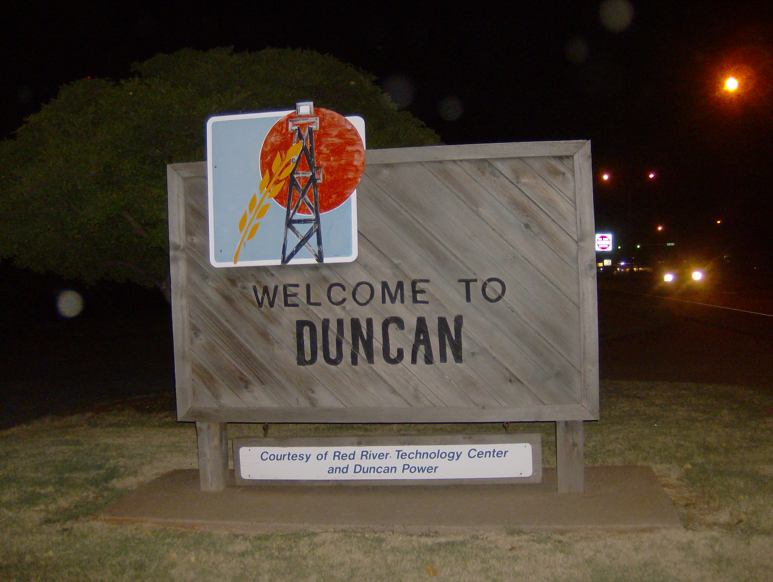
- Red River Technology Center is the city's vocational education institution.
- Cameron University also has a branch in Duncan.
Notable residents
- Jari Askins (1953– ) - Oklahoma State Representative; Lt. Governor of Oklahoma
- Hoyt Axton (1938–1999) - County Music Singer-Songwriter
- Erle P. Halliburton (1892–1957) - Founder, Halliburton Oil Well Cementing Company
- Jean Speegle Howard (1927–2000) - Actress
- Ron Howard (1954– ) - Actor, Director, Producer
- Jeane Kirkpatrick (1926–2006) - United States Ambassador to the United Nations
- Jackie Sherrill (1943- )- Former college football head coach
References
- ^ "American FactFinder". United States Census Bureau. http://factfinder.census.gov. Retrieved 2008-01-31.
- ^ "US Board on Geographic Names". United States Geological Survey. 2007-10-25. http://geonames.usgs.gov. Retrieved 2008-01-31.
- ^ "Find a County". National Association of Counties. http://www.naco.org/Counties/Pages/FindACounty.aspx. Retrieved 2011-06-07.
- ^ a b c d e f Savage, Cynthia. "Duncan" at Oklahoma Historical Society, Encyclopedia of Oklahoma History and Culture (accessed February 18, 2010).
- ^ a b c d e f g h i j k "2000 Reconnaissance Level Survey of Duncan" at Oklahoma Historical Society (accessed May 10, 2010)
- ^ "US Gazetteer files: 2010, 2000, and 1990". United States Census Bureau. 2011-02-12. http://www.census.gov/geo/www/gazetteer/gazette.html. Retrieved 2011-04-23.
- ^ "Best Places: Duncan, Oklahoma", U.S. News and World Report (accessed March 4, 2010).
- ^ "Attractions" at [http://www.duncanok.org/ Duncan, Oklahoma Convention Center and Visitor's Bureau[ (accessed February 18, 2010).
- ^ "Geography of Oklahoma" Wikipedia.org
- ^ "Climate and Geography at Duncan Chamber of Commerce and Industry Website (accessed March 22, 2010)
- ^ a b c d "Duncan," Travelok.com (accessed May 10, 2010).
- ^ "Duncan, Oklahoma" at www.bestplaces.net (accessed March 22, 2010)
- ^ "Historical Weather for Duncan, Oklahoma, United States". http://www.weatherbase.com/weather/weatherall.php3?s=27837&refer=.
- ^ "Halliburton to move jobs from Duncan to Houston." Associated Press at Tulsa World. February 18, 2010. Retrieved on April 5, 2010.
External links
- City of Duncan website
- Duncan Convention and Visitors Bureau website
- Encyclopedia of Oklahoma History and Culture - Duncan
Municipalities and communities of Stephens County, Oklahoma Cities 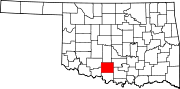
Towns Bray | Central High | Empire City | Loco | Velma
CDP Unincorporated
communitiesGhost town Arthur
County seats in Oklahoma Ada • Altus • Alva • Anadarko • Antlers • Arapaho • Ardmore • Arnett • Atoka • Bartlesville • Beaver • Boise City • Buffalo • Chandler • Chelsea • Cherokee • Cheyenne • Chickasha • Claremore • Coalgate • Duncan • Durant • El Reno • Enid • Eufaula • Fairview • Frederick • Guthrie • Guymon • Hobart • Holdenville • Hollis • Hugo • Idabel • Jay • Kingfisher • Lawton • Madill • Mangum • Marietta • McAlester • Medford • Miami • Muskogee • New Cordell • Newkirk • Nowata • Okemah • Oklahoma City • Okmulgee • Pauls Valley • Pawhuska • Pawnee • Perry • Poteau • Pryor • Purcell • Sallisaw • Sapulpa • Sayre • Shawnee • Stigler • Stillwater • Stilwell • Sulphur • Tahlequah • Taloga • Tishomingo • Tulsa • Vinita • Wagoner • Walters • Watonga • Waurika • Wewoka • Wilberton •
WoodwardCategories:- Cities in Oklahoma
- Populated places in Stephens County, Oklahoma
- County seats in Oklahoma
- Micropolitan areas of Oklahoma


Wikimedia Foundation. 2010.