- Turnpikes of Oklahoma
-
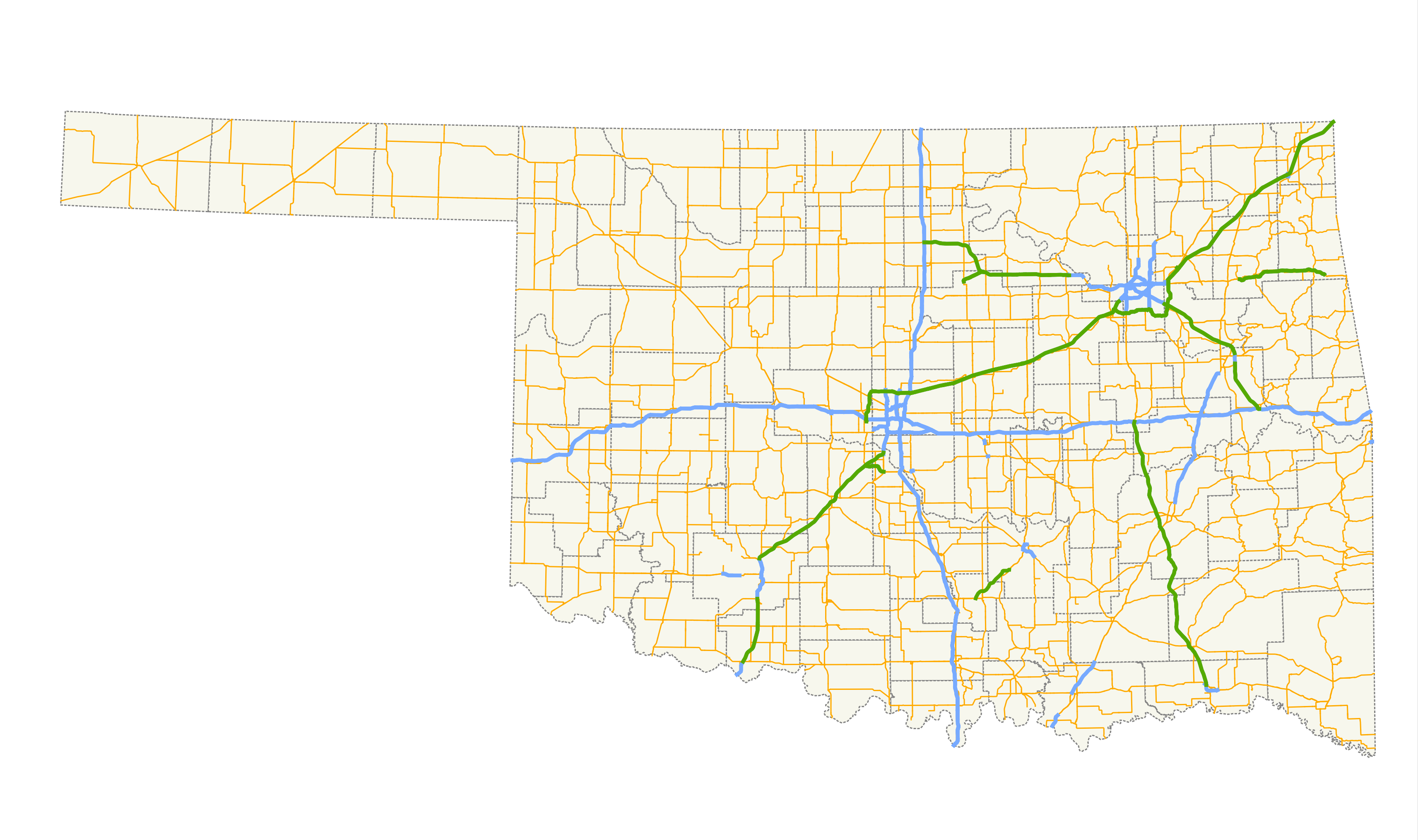
 Oklahoma highway system, with turnpikes shown in green
Oklahoma has an extensive turnpike system, maintained by the state government through the Oklahoma Turnpike Authority. All of Oklahoma's turnpikes are controlled-access. The majority have at least four lanes, though the Chickasaw Turnpike is two lanes.
Tolls on Oklahoma's turnpikes are collected through several methods, particular to each turnpike, involving mainline and sidegate toll plazas. Tolling is not ticket-based, as on other turnpikes, like the Kansas Turnpike to the north. Tolls can be paid through cash (at either unmanned exact-change bays or manned booths, depending on the plaza) or through the Pikepass transponder system.
Contents
Turnpikes
The Cherokee Turnpike is part of U.S. Highway 412 in eastern Oklahoma,
The Chickasaw Turnpike connects State Highway 7 just west of Sulphur to State Highway 1 south of Ada. The turnpike is two lanes for its entire length.
The Cimarron Turnpike begins at Interstate 35 in Noble County (east of Enid) and ends in the western suburbs of Tulsa. The turnpike is part of US-412. It also has a spur to the southwest to US-177 north of Stillwater.
The Creek Turnpike runs around the outskirts of Tulsa, forming a southern bypass of Tulsa's core area. The Creek Turnpike terminates at Interstate 44 on both ends, and acts as a bridge between the Turner and Will Rogers Turnpikes.
The H. E. Bailey Turnpike serves southwestern Oklahoma and is part of Interstate 44. The H.E. Bailey turnpike has two separate parts, with a free section running through eastern Lawton. This turnpike connects Wichita Falls, Texas to Lawton, Chickasha, and Oklahoma City. It has a spur to the east, the Norman Spur, towards Newcastle and Goldsby.
The Indian Nation Turnpike passes through southeast Oklahoma, beginning at Hugo, Oklahoma and angling northeast to end at Interstate 40 south of Henryetta, Oklahoma.
The Kilpatrick Turnpike runs through the north and west sides of the Oklahoma City metro, running from I-40 to I-35/44, where it becomes the Turner Turnpike. This route acts as one quarter of a pseudo-beltway, proving access to the suburbs of Yukon and Edmond.
The Muskogee Turnpike begins at the Creek Turnpike in east Tulsa and continues southeast to Muskogee. A second section of the turnpike connects Muskogee to I-40. The two sections are connected by a freeway, carrying part of State Highway 165.
The Turner Turnpike was Oklahoma's first turnpike, connecting Oklahoma City and Tulsa. The Turner Turnpike parallels historic U.S. Route 66 (now State Highway 66. It carries Interstate 44.
The Will Rogers Turnpike connects Tulsa to the Missouri state line near Joplin. Like the Turner Turnpike, this turnpike serves as a parallel route to US-66 and carries I-44. The rest area near Vinita is promoted as containing the World's Largest McDonald's.
Surveyed but not built
Shortly after the Turner Turnpike was built in 1953, the Oklahoma Turnpike Authority proposed other toll roads including one to be built from Oklahoma City north to the Kansas border near Braman to tie in with the southern terminus of the Kansas Turnpike at the state line. That routing was included as part of the Federal Highway Act of 1956 which created the Interstate Highway System. As a result, the OTA could not obtain financing to build that proposed turnpike and turned the initial plans including surveys and blueprints over to the Oklahoma Department of Transportation in 1956 for the construction of Interstate 35 as a freeway on that same alignment, which was completed in several stages between 1958 and 1962.
Also proposed but never built was a toll road roughly following what would later become I-35 between Oklahoma City and the Red River north of Gainesville, Texas that included a spur route veering from the main route north of Ardmore veering northeastward past Ada to tie in with the Turner Turnpike near Stroud.
Also proposed in the 1990s but never built was an extension of the Muskogee Turnpike from its current southeastern terminus at Interstate 40 southeastward toward Poteau.
Pikepass
Pikepass is the electronic toll collection system used by the Oklahoma Turnpike Authority. Created in 1990 and launched on January 1, 1991, Pikepass provides a faster and cheaper alternative in paying cash tolls. The Turnpike Authority also saves millions with the system.[1] Most customers pay an initial $40 in prepaid tolls, which they can refill at their own convenience or have funds automatically withdrawn to replenish the account if it falls below $10–15. Pikepass usage results in a 5% savings up front and customers with 20 or more uses of the Pikepass receive a credit of 5% of their toll charges for that month. The Pikepass device has been tested by the manufacturer to accurately record toll usage at speeds up to 123 miles per hour (198 km/h).
References
- ^ Janet Pearson (1990-11-17). "Toll Booths Going High-Tech". Tulsa World. http://tulsaworld.com/news/article.aspx?articleID=175361. Retrieved 2007-06-14.
Oklahoma turnpikes Cherokee · Chickasaw · Cimarron · Creek · H.E. Bailey · Indian Nation · John Kilpatrick · Muskogee · Turner · Will Rogers
Categories:- Toll roads in Oklahoma
- Freeways in the United States
Wikimedia Foundation. 2010.