- Oklahoma State Highway 9
-
State Highway 9
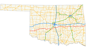
Route information Maintained by ODOT Length: 350 mi (560 km) Existed: 1924-08-24[1] – present Major junctions West end:  TX-203 at the Texas state line
East end: 
 I-540/US-271 at the Arkansas state line
Highway system Oklahoma State Highways
Oklahoma turnpike system←  SH-8
SH-8SH-10  →
→State Highway 9, abbreviated as SH-9, OK-9, or simply Highway 9, is a major east–west highway in the U.S. state of Oklahoma. Spanning across the central part of the state, SH-9 begins at the Texas state line near Madge, Oklahoma, and ends at the Arkansas state line near Fort Smith, Arkansas. State Highway 9 is a major highway around the Norman area. At 350 miles[2] (563.3 km), SH-9 is Oklahoma's second-longest state highway (second to State Highway 3).
Contents
Route description
West of Interstate 35
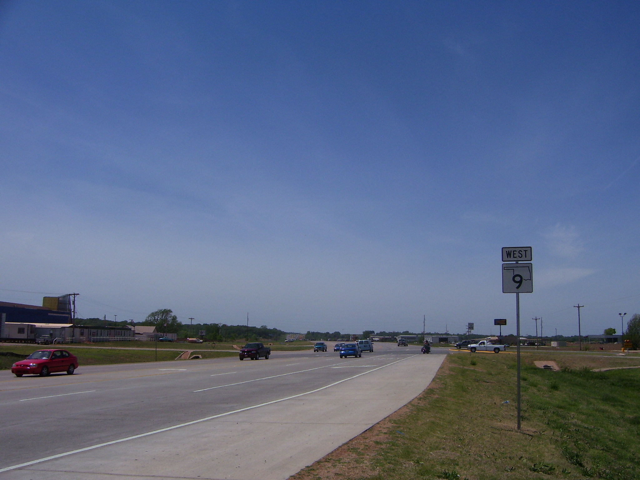
 A new SH-9 sign, of the 2006 design, just west of I-35 in Goldsby
From the western terminus at State Highway 203 along the Texas border, the highway travels due east for 5 miles (8.0 km)[3] and intersects with SH-30 between Madge and Vinson. SH-9 continues east for 23 miles (37 km)[3] without intersecting another highway until meeting US-283/SH-34, which is two miles (3 km) north of Mangum. The highway overlaps the other two routes for four miles (6 km), going north, before splitting off and heading east again through Granite and Lone Wolf. Near Hobart, SH-9 overlaps US-183 for 4 miles (6.4 km)[3] (again going northward) before splitting off again.
Continuing east, SH-9 passes through Gotebo, Mountain View, and Carnegie. Around Fort Cobb, Oklahoma, the highway begins 9 miles (14 km)[3] of travel to the south. There, the route links up with the concurrent U.S. Highways 62 and 281. While US-281 will split off in Anadarko, SH-9 and US-62 remain concurrent until Newcastle. In Chickasha, US-277 joins to form another three-route concurrency with US-62 and SH-9. On the eastern edge of Chickasha, US-62/277/SH-9 have an interchange with I-44, or more commonly known as the H.E. Bailey Turnpike.
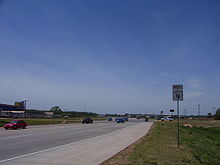
Traveling northeast from Chickasha, US-62/277/SH-9 are routed to the town of Blanchard. Four miles later, SH-9 splits away from the two U.S. routes at a diamond interchange that also serves as the eastern terminus of the H.E. Bailey Turnpike Spur. SH-9 remains without any concurrent routes until Goldsby. The section of road east of US-62/277, recently upgraded to a four-lane divided highway, provides a link from the H.E. Bailey Turnpike Spur to Interstate 35. At the interstate, SH-9 merges onto I-35 northbound to cross the Canadian River into Norman.
East of Interstate 35
 SH-9 East exiting from I-35 in Norman
Through Norman, Highway 9 serves as a major artery providing access to the University of Oklahoma campus (in particular, the Lloyd Noble Center). Around the area, the route is a four-lane divided highway (with surface crossings and stoplights). However, after a full interchange with US-77, the road becomes a two lane highway again.
SH-9 continues eastward, passing Lake Thunderbird and the Little River Zoo, before reaching the towns of Tecumseh and Seminole. The road intersects the Indian Nation Turnpike near Hanna, and US-69 near Eufaula. SH-9 provides access to the south side of Lake Eufaula before reaching Stigler.
SH-9 overlaps US-59 for 5 miles (8.0 km),[3] after which the road becomes concurrent with US-271. Both remain concurrent, until the highway ends at the Arkansas border. After passing the Arkansas state line, State Highway 9 becomes I-540, and US-271 continues over the state line concurrent with the Interstate.
History
 Original SH-9 shield
Officially designated on 1924-08-24[1], the original route encompassed all of current SH-9 west of Blanchard. East of Blanchard, SH-9 followed a more northerly route. Bypassing Norman, SH-9 ran north to Oklahoma City before going east through Harrah, Meeker, Prague, Henryetta, and Checotah. The highway ended at the original State Highway 3 in Spiro. Upon the creation of the United States Numbered Routes system in 1926, the section between Oklahoma City and Warner was overlaid with U.S. Highway 266.[4] Four years later in 1930, SH-9 was truncated to Chickasha.[1] By this time, much of the route had become part of U.S. Highway 62.[5]
On 1935-08-27, the route was extended eastward,[1] taking over the original SH-37. SH-9's eastern terminus became SH-48 near Seminole.[6] On 1937-08-25, the route was brought further east to end at US-69 in Eufaula.[1] Part of the newly commissioned section was rescinded on 1937-10-19,[1] when a small segment just east of SH-48 and the entire Hughes County portion were dropped from the highway.[7] These sections were re-added on 1938-09-27.[1]
State Highway 9 was extended eastward twice in the route's history. The first extension occurred on 1941-02-26,[1] and extended SH-9 to SH-2 at Whitefield.[8] The final extension brought SH-9 to the Arkansas state line on 1941-11-12.[1] The only major realignment in SH-9's history since 1941 was the Norman expressway bypass, which was designated as SH-9 on 1971-11-08.[1]
After the I-40 bridge disaster, parts of State Highway 9 in eastern Oklahoma served as an emergency detour for eastbound I-40 traffic. All eastbound traffic was routed along the section of SH-9 between SH-2 in Whitefield and US-59. In addition, the section of SH-9 between US-59 and the Arkansas state line were used for eastbound traffic for commercial trucks.[9][dead link]
Future
Discussions are under way to widen SH-9 to four lanes east of US-77 in Norman. The City of Norman and ODOT have conflict in their proposals for the design of the widened highway. ODOT has proposed a 16-foot (4.9 m) paved median, with 12-foot (3.7 m) shoulders to accommodate bicyclists. Norman's proposal includes a grass median and a separate bike path along the north side of the right-of-way, running from 24th Avenue S.E. to Lake Thunderbird. ODOT criticized the city's plan as too expensive. The city is now proposing a compromise, with a narrower raised concrete median and separate bike path.[10]
Spurs
State Highway 9 creates three spur highways throughout the state. Additionally, it has two business routes, serving towns the main route bypasses. These routes are:
- Business SH-9, a three mile (5 km) loop through Hobart.
- Another instance of Business SH-9 that loops through Gotebo. (This is not shown on the state highway map.)
 SH-9A shield
- SH-9A is a designation for three distinct highways:
Junction list
County Location Mile[2] Destinations Notes Harmon 0.0 SH 203Western terminus; Texas state line 4.9  SH-30
SH-30Greer 28.3 
 US-283/SH-34
32.2 US-283/SH-34Granite 39.2  SH-6
SH-6Kiowa Lone Wolf 47.6  SH-44
SH-4450.8 SH-44Hobart 56.1 
 BUS SH-9
Southern terminus of BUS SH-9 58.1  US-183
56.1
BUS SH-9Eastern terminus of BUS SH-9 61.6 US-183Gotebo 72.6  SH-54
SH-54Mountain View 79.7  SH-115
80.9 SH-115Caddo Carnegie 88.2  SH-58
SH-5897.9  SH-146
Southern terminus of SH-146 106.2 
 US-62/281
Anadarko 114.5 US-281/SH-8115.0 SH-8Grady Chickasha 130.8  US-81
US-81132.6  US-81/277
134.2  I-44/H.E. Bailey Turnpike
Diamond interchange 135.8  SH-92
SH-92Southern terminus of SH-92 Tabler 139.2  SH-39
SH-39Western terminus of SH-39 McClain Blanchard 150.7  SH-76
SH-76151.6 SH-76Newcastle 156.3 US-62/277/H.E. Bailey Norman SpurDiamond interchange Goldsby 162.4  I-35
I-35Irregular interchange; I-35 exit 106 Cleveland Norman 163.8 I-35Trumpet interchange; I-35 exit 108A 168.8  US-77
US-77Parclo interchange Pottawatomie 192.3  SH-102
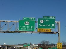
Tecumseh 199.7 
 US-177/SH-3W
205.3  SH-9A
SH-9AEarlsboro 206.5 SH-9ASeminole Seminole 212.5 
 US-270/SH-3E
214.2 
 US-377/SH-99
226.3  SH-56
SH-56Hughes 229.7  SH-48
SH-48Wetumka 239.0  US-75
US-75Dustin 252.2  SH-84
SH-84McIntosh 258.0 Indian Nation Turnpike 260.9  SH-52
SH-52Northern terminus of SH-52 Eufaula 278.2  US-69
US-69Parclo interchange 278.9
BUS US-69279.9
BUS US-69283.6 SH-9AEastern terminus of SH-9A Haskell Enterprise 293.8  SH-71
SH-71Whitefield 302.2  SH-2
SH-2Stigler 308.7  SH-82
SH-82Northern terminus of SH-82 318.6  SH-26
SH-26Northern terminus of SH-26 Le Flore 330.1  US-59
US-59335.6 US-59/271Braden 344.9 SH-9ASouthern terminus of SH-9A 347.3  SH-112
349.6 SH-112350.1 I-540Eastern terminus; Arkansas state line 1.000 mi = 1.609 km; 1.000 km = 0.621 mi References
- ^ a b c d e f g h i j Oklahoma Department of Transportation. "Memorial Dedication and Revision History". http://www.okladot.state.ok.us/memorial/legal/sh9.htm. Retrieved 2007-11-04.
- ^ a b Stuve, Eric. "OK-9". OKHighways. http://www.okhighways.com/ok9.html. Retrieved 2007-10-11.
- ^ a b c d e Oklahoma Department of Transportation. 2007 Centennial State Map (Map).
- ^ Oklahoma Department of Highways. Oklahoma State Highway System (Map) (1927 ed.). http://www.odot.org/hqdiv/p-r-div/maps/state-maps/pdfs/1927.pdf. Retrieved 2007-11-06.
- ^ Oklahoma Department of Highways. Map Showing Condition of Improvement of the State Highway System (Map) (1931 ed.). http://www.odot.org/hqdiv/p-r-div/maps/state-maps/pdfs/1931.pdf. Retrieved 2007-11-06.
- ^ Oklahoma Department of Highways. Map Showing Condition of Improvement of the State Highway System and Landing Fields (Map) (1936 ed.). http://www.odot.org/hqdiv/p-r-div/maps/state-maps/pdfs/1936.pdf. Retrieved 2007-11-06.
- ^ Oklahoma Department of Highways. Map Showing Condition of Improvement of the State Highway System (Map) (1938 ed.). http://www.odot.org/hqdiv/p-r-div/maps/state-maps/pdfs/1938.pdf. Retrieved 2007-11-06.
- ^ Oklahoma Department of Highways. Map Showing Condition of Improvement of the State Highway System (Map) (1941 ed.). http://www.odot.org/hqdiv/p-r-div/maps/state-maps/pdfs/1941.pdf. Retrieved 2007-11-06.
- ^ Oklahoma Department of Transportation. I-40 Arkansas River Bridge Detour Routes (Map). http://www.odot.org/public-info/i40bridge/agifs/I-40DetourLocall.gif. Retrieved 2007-12-16.
- ^ Cannon, Jane Glen (2008-09-17). "Highway widening talks continue". The Oklahoman: p. VI 1.
External links
Roads of Fort Smith Interstate Highways 
U.S. Routes Arkansas Highways Oklahoma State Highways Categories:- State highways in Oklahoma


Wikimedia Foundation. 2010.